Fisherman's Island State Park
| Fisherman's Island State Park | |
|---|---|
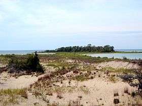 Fisherman Island photographed when connected to the mainland | |
 Location in Michigan | |
| Location |
Norwood Township Charlevoix County, Michigan |
| Nearest city | Charlevoix, Michigan |
| Coordinates | 45°16′00″N 85°21′40″W / 45.26667°N 85.36111°WCoordinates: 45°16′00″N 85°21′40″W / 45.26667°N 85.36111°W [1] |
| Area | 2,678 acres (1,084 ha) |
| Elevation | 640 feet (200 m) [1] |
| Governing body | Michigan Department of Natural Resources |
| Website | Fisherman's Island State Park |
Fisherman's Island State Park is public recreation area of 2,678 acres (1,084 ha) sitting on six miles (9.7 km) of the Lake Michigan shoreline southwest of Charlevoix, Michigan. [2] Due to historically low lake levels, for most of 1998 to 2016 the small Fisherman Island,[1] for which the state park was named, had become attached to the mainland via a tombolo. [3]
Activities and amenities
The island is located 0.7 miles (1.2 km) from the picnic area. The park features rustic campgrounds with some of the sites nestled in the dunes along the lake shore. The park road travels through the campground to the picnic area with access to swimming beaches and over three miles of hiking trails. The interior terrain consists largely of rolling dunes covered with maple, birch and aspen broken up by bogs of cedar and black spruce. Hunting and snowmobiling are also permitted. The park is operated by the Michigan Department of Natural Resources.[2]
References
- 1 2 3 "Report For Fisherman Island". USGNIS. Retrieved 11 September 2018.
- 1 2 "Fisherman's Island State Park". Michigan Department of Natural Resources. Retrieved September 26, 2011.
- ↑ "Great Lakes Dashboard Project". Great Lakes Environmental Research Laboratory. Retrieved September 15, 2018.
External links
- Fisherman's Island State Park Michigan Department of Natural Resources
- Fisherman's Island State Park Map Michigan Department of Natural Resources
- Fisherman's Island State Park Protected Planet