Felts Field
| Felts Field | |||||||||||||||
|---|---|---|---|---|---|---|---|---|---|---|---|---|---|---|---|
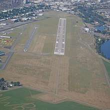 Felts Field looking west | |||||||||||||||
| Summary | |||||||||||||||
| Airport type | Public | ||||||||||||||
| Owner | Spokane City-County | ||||||||||||||
| Serves | Spokane, Washington | ||||||||||||||
| Elevation AMSL | 1,957 ft / 596 m | ||||||||||||||
| Coordinates | 47°40′59″N 117°19′21″W / 47.68306°N 117.32250°WCoordinates: 47°40′59″N 117°19′21″W / 47.68306°N 117.32250°W | ||||||||||||||
| Website |
www | ||||||||||||||
| Map | |||||||||||||||
 SFF Location of airport in Washington / United States  SFF SFF (the US) | |||||||||||||||
| Runways | |||||||||||||||
| |||||||||||||||
| Statistics | |||||||||||||||
| |||||||||||||||
Felts Field (IATA: SFF, ICAO: KSFF, FAA LID: SFF) is a public airport five miles northeast of downtown Spokane, in Spokane County, Washington. It is owned by Spokane City-County.[1]
The airport has two hard surface runways. Felts Field is used for general aviation now, but it was Spokane's airline airport before the opening of Spokane International Airport.
It is included in the Federal Aviation Administration (FAA) National Plan of Integrated Airport Systems for 2017–2021, in which it is categorized as a regional reliver facility.[2]
History
Felts Field, Spokane's historic airfield, is on the south bank of the Spokane River east of Spokane. Aviation activities began in 1913. In 1920 the field, then called the Parkwater airstrip, was designated a municipal flying field at the instigation of the Spokane Chamber of Commerce. In 1926, the United States Department of Commerce recognized Parkwater as an airport, one of the first in the West. In September 1927, in conjunction with Spokane’s National Air Derby and Air Races, the airport was renamed Felts Field for James Buell Felts (1898–1927), a Washington Air National Guard aviator killed in a crash that May. Parkwater Aviation Field, later Felts Field, was the location for flight instruction, charter service, airplane repair, aerial photography, headquarters of the 116th Observation Squadron of the Washington Air National Guard, and eventually the first airmail and commercial flights in and out of Spokane.
After World War II, commercial air traffic moved to Geiger Field (later Spokane International Airport). Felts Field remains a busy regional hub for private and small-plane aviation and related businesses and services. In 1991 it was designated Felts Field Historic District on the National Register of Historic Places.[3][4]
_1934.jpg)
Today the airport is used for general aviation. No scheduled passenger service remains at Felts, though commercial scheduled Part 135 cargo operations remain via UPS and DHL contracting (Ameriflight LLC and previously Merlin Express Airways).
Facilities
Felts Field covers 416 acres (168 ha) at an elevation of 1,957 feet (596 m). It has two runways: 4L/22R is 4,499 by 150 feet (1,371 x 46 m) concrete and 4R/22L is 2,650 by 75 feet (808 x 23 m) asphalt. It has a seaplane landing area designated 3W/21W, 6,000 by 100 feet (1,829 x 30 m).[1]
For the 12-month period ending February 28, 2015, the airport had 54,881 aircraft operations, average 150 per day: 93% general aviation, 7% air taxi, and <1% military. In July 2017, 176 aircraft were based at this airport: 146 single-engine, 15 multi-engine, and 15 helicopters.[1]
Cargo carriers
| Airlines | Destinations |
|---|---|
| AirPac Airlines[5] | Portland (OR), Seattle–Boeing |
Accidents and incidents
On November 29, 2003 an Ameriflight LLC cargo (Fairchild Swearingen Metroliner) (N439AF) crashed on approach to runway 21R at Felts Field using ILS. The pilot's HSI was previously noted as inoperative, deferred, and due for scheduled maintenance. It is unclear whether the pilot was using backup instrumentation as prescribed via the deferral process or using the faulty HSI. The Metro III failed to maintain ILS glide slope and crashed short of the runway into rising terrain and trees. The pilot was killed during the subsequent impact and fire. The aircraft was damaged beyond repair.[6]
See also
References
- 1 2 3 4 FAA Airport Master Record for SFF (Form 5010 PDF). Federal Aviation Administration. effective July 20, 2017.
- ↑ "List of NPIAS Airports" (PDF). FAA.gov. Federal Aviation Administration. 21 October 2016. Retrieved 26 July 2017.
- ↑ "Felts Field History". Retrieved 2011-07-19.
- ↑ "WASHINGTON - Spokane County". National Register of Historic Places. Retrieved 2009-01-15.
- ↑ AirPac Airlines
- ↑ "Flight 1966 crash". Retrieved 2011-07-19.
External links
- Aviation: From Sand Dunes to Sonic Booms, a National Park Service Discover Our Shared Heritage Travel Itinerary
- FAA Airport Diagram (PDF), effective October 11, 2018
- FAA Terminal Procedures for SFF, effective October 11, 2018
- Resources for this airport:
- FAA airport information for SFF
- AirNav airport information for KSFF
- ASN accident history for SFF
- FlightAware airport information and live flight tracker
- NOAA/NWS latest weather observations
- SkyVector aeronautical chart, Terminal Procedures