Friday Harbor Airport
| Friday Harbor Airport | |||||||||||
|---|---|---|---|---|---|---|---|---|---|---|---|
|
| |||||||||||
 | |||||||||||
| Summary | |||||||||||
| Airport type | Public | ||||||||||
| Owner | Port of Friday Harbor | ||||||||||
| Serves | Friday Harbor, Washington | ||||||||||
| Elevation AMSL | 113 ft / 34 m | ||||||||||
| Coordinates | 48°31′19″N 123°01′28″W / 48.52194°N 123.02444°WCoordinates: 48°31′19″N 123°01′28″W / 48.52194°N 123.02444°W | ||||||||||
| Website | https://www.portfridayharbor.org/ | ||||||||||
| Map | |||||||||||
 FHR Location of airport in Washington / United States  FHR FHR (the US) | |||||||||||
| Runways | |||||||||||
| |||||||||||
| Statistics (2013) | |||||||||||
| |||||||||||
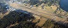
Friday Harbor Airport (IATA: FRD, ICAO: KFHR, FAA LID: FHR) is a public use airport located just southwest of the town center of Friday Harbor on San Juan Island in the U.S. state of Washington. It is owned by the Port of Friday Harbor.[1] Friday Harbor is also the default airport of Microsoft Flight Simulator X, although Aircraft spawn in the air above the airport and must land there first.
Although most U.S. airports use the same three-letter location identifier for the FAA and IATA, this airport is assigned FHR by the FAA and FRD by the IATA.[2]
Facilities and aircraft
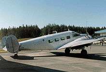
Friday Harbor Airport covers an area of 145 acres (59 ha) which contains one runway (16/34) with a 3,402 x 75 ft (1,037 x 23 m) asphalt pavement. For the 12-month period ending May 31, 2011, the airport had 48,766 aircraft operations, an average of 134 per day: 42% local general aviation, 28% transient general aviation, and 30% air taxi. At that time there were 142 aircraft based at this airport: 95% single-engine and 5% multi-engine.[1]
Airlines and destinations
Passenger
| Airlines | Destinations |
|---|---|
| AlbionAir | Aurora (OR) |
| Kenmore Air | Roche Harbor, Seattle–Boeing, Seattle/Lake Union |
| San Juan Airlines | Anacortes, Bellingham, Lopez Island, Eastsound, Tofino, Vancouver |
| NorthStar Air Tours | Victoria (BC), Eastsound |
Cargo
| Airlines | Destinations |
|---|---|
| FedEx Feeder | Seattle/Tacoma |
References
- 1 2 3 FAA Airport Master Record for FHR (Form 5010 PDF), effective 2007-12-20
- ↑ Great Circle Mapper: FRD / KFHR - Friday Harbor, Washington
External links
- Port of Friday Harbor: Airport Section
- Friday Harbor Airport at Washington State DOT
- FAA Terminal Procedures for FHR, effective October 11, 2018
- Resources for this airport:
- FAA airport information for FHR
- AirNav airport information for KFHR
- ASN accident history for FRD
- FlightAware airport information and live flight tracker
- NOAA/NWS latest weather observations
- SkyVector aeronautical chart, Terminal Procedures