Fairfield Heights, New South Wales
| Fairfield Heights Sydney, New South Wales | |||||||||||||||
|---|---|---|---|---|---|---|---|---|---|---|---|---|---|---|---|
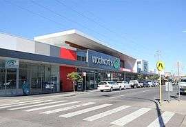 Woolworths, in the suburb's main street, The Boulevard | |||||||||||||||
| Population | 7,517 (2016 census)[1] | ||||||||||||||
| Postcode(s) | 2165 | ||||||||||||||
| Location | 31 km (19 mi) W of Sydney CBD | ||||||||||||||
| LGA(s) | City of Fairfield | ||||||||||||||
| State electorate(s) | Fairfield | ||||||||||||||
| Federal Division(s) | McMahon | ||||||||||||||
| |||||||||||||||
Fairfield Heights is a suburb of Sydney, in the state of New South Wales, Australia. Fairfield Heights is located 31 kilometres west of the Sydney central business district in the local government area of the City of Fairfield. Fairfield Heights is part of the Greater Western Sydney region.
Fairfield Heights shares the postcode of 2165 with the separate suburbs of Fairfield, Fairfield East and Fairfield West. The majority of residents speak a language other than English at home, with the most common one being Assyrian Neo-Aramaic.[1] Fairfield Heights, like Fairfield, is also an ethnic enclave of Assyrians.[2]
The elevation of this suburb is approximately between 30–40 metres above mean sea level, owing to its name.
History
Aboriginal people from the Cabrogal tribe, a sub-group of the Gandangara tribe, have lived in the Fairfield area for over 30 000 years. White settlement came to the area in the early 19th century. An application for a post office at Fairfield Heights was made by Mrs Beard in 1950. In 1955, when the population had increased sufficiently a post office was opened.
Commercial area
Fairfield Heights mostly consists of low-density residential and commercial developments. Its commercial area is centred on The Boulevarde, the main street in Fairfield Heights, which is the highest point in the suburb at 40 metres above sea level, offering striking views of the lower areas to the south and east.
The Boulevarde mainly features cafes, ethnic restaurants (such as Hammurabi Restaurant and Al Basha), with a few featuring a hookah lounge, delis and convenient stores. Other businesses include dollar stores, health clinics, a radiology centre, cosmetic clinics, Domino's Pizza and Pizza Hut outlets, and a Vinnies store. Despite its small size, business hours in Fairfield Heights are slightly more extended than those in the neighbouring large suburb of Fairfield, with a few cafes, bars and restaurants open until 9pm.[3]
Culture
Assyrian Sports and Cultural Club is the prominent club in the suburb, which features a casino, reception, restaurants (which contains an all-you-can-eat buffet) and it has an entertainment quarter which hosts music concerts.
The Club was originally opened in 1990, in The Boulevarde, where it held liquor and gaming licenses. In 1997 the Club bought the premises at 52-54 Stanbrook Street. The project of turning the gymnasium, squash courts and fruit shop into a club began in January 2000. The new club site was eventually opened by former Mayor Anwar Khoshaba in a ceremony that was visited by politicians, Councillors and many Assyrians. In 2003, the reception hall was built and the club grounds were expanded to fit weddings and other social events.[4]
Today, Hammurabi Restaurant is located on Cultural Club's old premises in The Boulevarde. It is an ethnic restaurant, serving Assyrian cuisine and Iraqi cuisine, and it features a reception hall for joyous events, namely for Assyrians.[5]
Recreational and sports
Prospect View Reserve, an urban park, is home to the historic Fairfield Hotspurs Football Club, the junior club of Harry Kewell. The reserve is a large floodlit sports ground, which features a soccer and football field. Fairfield Heights Park is medium-sized suburban park that contains natural bushland, children's playgrounds and footpaths for walking or jogging. Although not situated in the suburb, Brenan Park is fairly proximate to the western outskirts of Fairfield Heights.
Education
There is one local primary school, Fairfield Heights Public School, established in 1952. There are no high schools within the Fairfield Heights locality and residents to the east of this area are in the catchment area closest to Fairfield High School. A public secondary school, Fairvale High School, serves those residents living towards Hamilton Road on the southern side of Fairfield Heights. A special high school, Westfields Sports High, is two kilometres to the south west and is available to Fairfield Heights residents who meet the entrance requirements. Fairfield library and the community library at Smithfield, a suburb two kilometres to the northwest, are the nearest libraries for residents of Fairfield Heights.
Places of worship
Holy Apostolic Catholic (Universal) Assyrian Church of East St Mary’s Church, Holy Apostolic Catholic (Universal) Chaldeans and Assyrians St Mary’s Assumption Church, St Therese's Catholic Church is located in this suburb.
Demographics
At the 2016 census, there were 7,517 residents in Fairfield Heights. 33.7%% of people were born in Australia. The most common other countries of birth were Iraq 25.1%, Vietnam 9.0%, Cambodia 3.1%, Syria 2.9% and China 1.9%. The top languages were Assyrian Neo-Aramaic 17.0%, Arabic 13.5%, Vietnamese 12.4%, Chaldean Neo-Aramaic 7.9% and Khmer 3.2%. Aboriginal and/or Torres Strait Islander people made up 0.5% of the population.
The most common ancestries were Assyrian 14.2%, Vietnamese 10.7%, Iraqi 9.4%, Chinese 8.2% and Australian 6.8%.
The most common responses for religion were Catholic 34.7%, Buddhism 12.2%, No Religion 9.3%, Assyrian Church of the East 8.2% and Islam 7.8%. Christianity was the largest religious group reported overall (66.0%).[1]
Notable residents
Fairfield Heights was once the home of tennis player Jelena Dokić and her family.[6]
References
- 1 2 3 Australian Bureau of Statistics (27 June 2017). "Fairfield Heights (State Suburb)". 2016 Census QuickStats. Retrieved 27 June 2017.

- ↑ B. Furze, P. Savy, R. Brym, J. Lie, Sociology in Today's World, 2008, p. 349
- ↑ Deniz, F. 2000, ‘Maintenance and Transformation of Ethnic Identity: the Assyrian Case’, The Assyrian Australian Academic Journal
- ↑ Assyrian Australian Association & Ettinger House 1997, Settlement Issues of the Assyrian Community, AAA, Sydney.
- ↑ Gorgees, P. 2003, ‘The Assyrian Community’s Continued Needs in the Fairfield LGA’, in Checking the Pulse of Fairfield―Conference Report, Fairfield Migrant Resource Centre, Cabramatta.
- ↑ "poidb.com". Retrieved 4 May 2013.
Coordinates: 33°52′07″S 150°56′33″E / 33.86848°S 150.94239°E