Fairfax, Washington
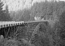
Fairfax was a coal town in Pierce County in the U.S. state of Washington. Mining lasted only until the minerals ceased to be economically viable following World War I.[1] Until the completion of the nearby 240 feet (73 m) high Farrell Bridge in 1921 (the highest bridge in the state at the time), the town was only accessible via railroad or pack train.[2] The town is memorialized in a song by singer Ron Fowler, "Road to Fairfax", on his independently released CD, "Radio Frequency".[3]
History
The development of coal first began in 1896 when the Western American Company owned Section 26, T.18N., R.6E which was more commonly known as the Fairfax Mine, a railroad linked Carbonado, Washington to Fairfax with the first shipment of coal being sent out in 1899.[4] Pierce County was one of the only counties in Washington State to produce a coke and in 1902 the Western American Company installed 35 coke ovens and Fairfax was helping lead the way in coke production in the county.[5] In 1906 the Fairfax mine had a total output of 20,000 tons of coal during a nine month period.[6] During the other three months of 1906 the mine put out 1,858 tons of coal during a 35 day period. In total in 1906, the mine put out 21,858 tons of coal.[7] In 1909 there was an ad that the mine was looking for a coal mine electrician.[8] In 1910 the Manley, Moore Lumber Company was looking to add millwrights and was willing to pay them $3.50-$4 per day. They were also looking for common laborers and was offering them $2.25-$2.50 per day to come work in Fairfax.[9] These ads show that between these years the mine was making enough money that the town was actively searching for new workers. The most productive years of the Fairfax mine was short lived but for a time was profitable. The town is now a destination for hikers and is considered a ghost town.[10]
Geography
The town was located on the Carbon River about 6 miles (10 km) south of Carbonado, Washington, on SR 165, at 47°00′41″N 122°00′54″W / 47.01139°N 122.01500°WCoordinates: 47°00′41″N 122°00′54″W / 47.01139°N 122.01500°W (47.011, -122.015)
See also
References
- ↑ http://historylink.org/index.cfm?DisplayPage=output.cfm&file_id=8262
- ↑ http://www.wsdot.wa.gov/environment/culres/bridges/bridge_pierce_072.htm
- ↑
- ↑ Washington Division of Geology and Earth Resources. "Mining of Pierce County, Washington Coal Field, 1860-1962." Joseph Daniels. Report OF 79-1. 1979. http://www.dnr.wa.gov/Publications/ger_ofr79-1_mining_history_pierce_co.pdf
- ↑ "Coal Output of Year: Mine Inspector’s Annual Report," Seattle Daily Times (Seattle, WA), February 25, 1902.
- ↑ "1906 Record Year in Production of Coal," Seattle Daily Times (Seattle, WA), December 19, 1906.
- ↑ "Cola Increase is 15 ½ Per Cent," Seattle Daily Times (Seattle, WA), February 2, 1907.
- ↑ "WANTED-Experienced coal mine electrician," Seattle Daily Times (Seattle, WA), April 23, 1909.
- ↑ "WANTED-Millwrights for new work," Seattle Daily Times (Seattle, WA), May 9, 1910.
- ↑ Craig Hill, "Trail of the Week: Manley-Moore to Fairfax," The News Tribune (Tacoma, WA), August 11, 2016.
Municipalities and communities of Pierce County, Washington, United States | ||
|---|---|---|
| Cities | 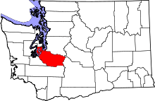 | |
| Towns | ||
| CDPs |
| |
| Other unincorporated communities | ||
| Indian reservation | ||
| Military bases | ||
| Ghost towns | ||
| Footnotes | ‡This populated place also has portions in an adjacent county or counties | |