Canterwood, Washington
| Canterwood, Washington | |
|---|---|
| CDP | |
 Canterwood, Washington | |
| Coordinates: 47°22′35″N 122°36′08″W / 47.37639°N 122.60222°WCoordinates: 47°22′35″N 122°36′08″W / 47.37639°N 122.60222°W | |
| Country |
|
| State |
|
| County | Pierce County, Washington |
| Area | |
| • Total | 5.6 km2 (2.17 sq mi) |
| Elevation | 102 m (335 ft) |
| Population (2010) | |
| • Total | 3,076 |
| • Density | 550/km2 (1,400/sq mi) |
| Time zone | Pacific |
| Area code(s) | 360 |
Canterwood is a CDP located in Pierce County, Washington.
Demographics
In 2010, it had a population of 3,079 inhabitants. 1,473 are male. 1,606 are female.[1]
Geography
Canterwood is located at coordinates 47°22′35″N 122°36′08″W.
References
- ↑ "Canterwood, Washington". Retrieved 20 August 2014.
Municipalities and communities of Pierce County, Washington, United States | ||
|---|---|---|
| Cities | 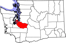 | |
| Towns | ||
| CDPs |
| |
| Other unincorporated communities | ||
| Indian reservation | ||
| Military bases | ||
| Ghost towns | ||
| Footnotes | ‡This populated place also has portions in an adjacent county or counties | |
This article is issued from
Wikipedia.
The text is licensed under Creative Commons - Attribution - Sharealike.
Additional terms may apply for the media files.