European route E22
| |
|---|---|
 | |
| Route information | |
| Length | 5,320 km (3,310 mi) |
| Major junctions | |
| West end | Holyhead, United Kingdom |
| |
| East end | Ishim, Russia |
| Location | |
| Countries |
|
| Highway system | |
| International E-road network | |
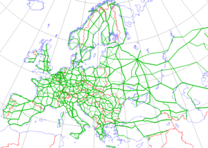
The European route E 22 is one of the longest European routes. It has a length of about 5,320 km (3,310 mi). Many of the E-roads have been extended into Asia since the year 2000; the E 22 was extended on 24 June 2002.
Route

Port of Holyhead ![]()

- Ewloe Interchange (53°11′15″N 3°03′51″W / 53.18752°N 3.06427°W)
- Dunkirk Roundabout (53°14′43″N 2°56′14″W / 53.24527°N 2.93714°W)

- Lymm Interchange (53°21′09″N 2°30′10″W / 53.3525°N 2.5029°W)

- Croft Interchange (53°25′34″N 2°33′22″W / 53.426°N 2.5561°W)

- Eccles Interchange (53°29′15″N 2°22′36″W / 53.48761°N 2.37666°W)

.svg.png)
- Langham Interchange (53°41′04″N 0°58′09″W / 53.6844°N 0.9693°W)


- North Ings Interchange (53°35′29″N 0°59′14″W / 53.5915°N 0.9872°W)


- Brocklesby Interchange (53°36′51″N 0°16′58″W / 53.61415°N 0.28289°W)
Port of Immingham ![]()

Amsterdam (52°22′N 4°54′E / 52.367°N 4.900°E)


- Coenplein (52°25′23″N 4°52′34″E / 52.4231°N 4.876°E)
- Knooppunt Zaandam (52°27′20″N 4°50′29″E / 52.4556°N 4.8415°E)


- Westerbroek (53°12′15″N 6°37′56″E / 53.20416°N 6.63233°E)
Bad Nieuweschans (53°10′50″N 7°12′26″E / 53.18056°N 7.20722°E)

Bunde (53°11′N 7°16′E / 53.183°N 7.267°E)


Sassnitz ![]()
Elbe Crossing
There are currently plans to reroute the E22 between Lübeck and Westerstede, to go north of Hamburg and Bremen over the A20, when this new motorway is built after 2020. The E22 would then use the planned tunnel under the Elbe at Drochtersen/Glückstadt.

Trelleborg ![]()


- Trafikplats Petersborg (55°32′51″N 13°00′08″E / 55.5474°N 13.0023°E)


- Trafikplats Kronetorp (55°38′28″N 13°06′17″E / 55.6411°N 13.1047°E)

Norrköping (58°36′N 16°12′E / 58.600°N 16.200°E)
In Sweden, E-Roads do not have national numbers. There is currently no ferry across the Baltic Sea between Norrköping and Ventspils. The best ferry alternative is from Nynäshamn to Ventspils. The line is run by Scandlines.


Between Kazan and Igra, the road goes the detour over Yelabuga, because the shortest route between Kazan and Igra uses a ferry over the Vyatka River (56°35′31″N 50°42′32″E / 56.592°N 50.709°E), and the road is a bad gravel road around that area. Google Maps shows the ![]()
Between Perm and Ishim, the ![]()
Gallery


| Wikimedia Commons has media related to E22. |
External links
Transport in Greater Manchester | |||||||
|---|---|---|---|---|---|---|---|
| Air |  | ||||||
| Bus |
| ||||||
| Road | |||||||
| Tram | |||||||
| Cycle | |||||||
| Rail |
| ||||||
| TIF bid | |||||||
| |||||||