Erzen River
| Erzen | |
|---|---|
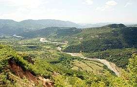 The river close to Iba village | |
| Country | Albania |
| Physical characteristics | |
| Main source |
Mali me Gropa, Shëngjergj Tirana County 1,200 m (3,900 ft) 41°19′37″N 20°4′47″E / 41.32694°N 20.07972°E |
| River mouth |
Lalzi Bay[1] Adriatic Sea 0 m (0 ft) 41°26′13″N 19°27′35″E / 41.43694°N 19.45972°ECoordinates: 41°26′13″N 19°27′35″E / 41.43694°N 19.45972°E |
| Length | 109 km (68 mi)[2] |
| Basin features | |
| Basin size | 760 km2 (290 sq mi) |
The Erzen (definite Albanian form: Erzeni) is a river in central Albania. The length of Erzen is 109 km (68 mi), while the catchment area is 760 km2 (290 sq mi) including the southern Tirana District and eastern Durrës District.[3]
The river has its origin in the Mali me Gropa 1,200 m (3,900 ft) elevation above sea level and is some 25 km (16 mi) east of Tirana near Shëngjergj, flowing northwest through Petrelë and Sukth to the Adriatic Sea 12 km (7.5 mi) north of Durrës.[4] Significant tributaries of Erzen include Lake Farkë, Korrë, Lanë, Murdhar, Shtërmen and Zhëllimë.
The river passes through the city of Tirana, only a few kilometers from its southern end. Only a small range of hills separates the valley of the Erzen river with the Lana, Tirana, Zeza and Tërkuza rivers that form the Ishem river. On the southwestern outskirts at Yzberisht the transition from the plane to the Erzen valley is barely perceptible. The mouth is between Durres and the headland of Cape of Rodon at Lalzi bay. The average discharge rate at the mouth is 18.1 m³ / s, the highest discharge rate for the year exceeds minimum to the eleven-time. Its drainage area which includes all Tirana District and a part of Durres area is about 700 square km.
Apparently, all twenty-two victims of the 1951 massacre were dumped into the river on Enver Hoxha's orders, only to later be found wrapped tightly in barbed tape.
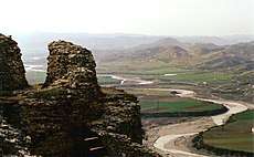 Erzen Valley seen from Petrelë Castle |
 Bridge near Shijak in 1914 |
See also
| Wikimedia Commons has media related to Erzen. |
References
- ↑ "Costal vegetation of the Lalzi bay (Albania)" (PDF). botanicaserbica.bio.bg.ac.rs. p. 1.
- ↑ TREGUES SIPAS QARQEVE INDICATORS BY PREFECTURES at the Wayback Machine (archived 2011-07-24)
- ↑ "The coastline of Albania : morphology, evolution and coastal management issues" (PDF). ciesm.org. p. 8.
- ↑ "Hydronymica Albanica — A Survey of River Names in Albania" (PDF). elsie.de. p. 12.