Eratosthenes (crater)
.png) | |
| Coordinates | 14°28′N 11°19′W / 14.47°N 11.32°WCoordinates: 14°28′N 11°19′W / 14.47°N 11.32°W |
|---|---|
| Diameter | 59 km |
| Depth | 3.6 km |
| Colongitude | 12° at sunrise |
| Eponym | Eratosthenes |

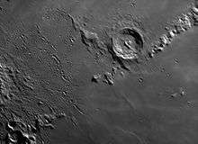
Eratosthenes crater is a relatively deep lunar impact crater that lies on the boundary between the Mare Imbrium and Sinus Aestuum mare regions. It forms the western terminus of the Montes Apenninus mountain range.
Description
The crater has a well-defined circular rim, terraced inner wall, central mountain peaks, an irregular floor, and an outer rampart of ejecta. It lacks a ray system of its own, but is overlain by rays from the prominent crater Copernicus to the south-west.
One other crater to the south-southwest is Stadius located over a crater diameter distant.
The Eratosthenian period in the lunar geological timescale is named after this crater, though it does not define the start of this time period.[1] The crater is believed to have been formed about 3.2 billion years ago.
At low Sun-angles, this crater is prominent due to the shadow cast by the rim. When the Sun is directly overhead, however, Eratosthenes visually blends into the surroundings, and it becomes more difficult for an observer to locate it. The rays from Copernicus lie across this area, and their higher albedo serves as a form of camouflage.
In 1851 Shropshire Astronomer Henry Blunt constructed a model of the moon's surface showing Eratosthenes. The model is based on observations made by Blunt with a reflecting telescope from his home in Shrewsbury and was displayed in the same year at the Great Exhibition, London.
In 1910–1920th, William H. Pickering noted dark patches in the crater that varied in a regular manner over each lunar day. He put forward the speculative idea that these patches appeared to migrate across the surface, suggestive of herds of small life forms.[2][3] The idea received a degree of attention primarily due to Pickering's reputation.

Names
The crater is named after ancient Greek astronomer Eratosthenes of Cyrene,[4] who estimated the circumference of the Earth, and the distance from the Earth to the Sun. It was given its name by Giovanni Riccioli, whose 1651 nomenclature system has become standardized.[5][6] Earlier lunar cartographers had given the feature different names. Michael van Langren's 1645 map calls it "Haro".[7][8] And Johannes Hevelius called it "Insula Vulcania" of the ancient world, also to the south, he named "Montes Chalcidici" to what are now the eastern part of the Copernicus ray system.[9]
An earlier feature was named Sinus Eratosthenes (Bay of Eratosthenes) in Michael van Langren's 1645 map[8] That part, thought to be a straight, it actually a terrain (or land) separating Mare Fecunditatis and Mare Spumans.
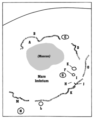
Satellite craters
By convention these features are identified on lunar maps by placing the letter on the side of the crater midpoint that is closest to Eratosthenes.
| Eratosthenes | Coordinates | Diameter, km |
|---|---|---|
| A | 18°20′N 8°20′W / 18.34°N 8.33°W | 5.7 |
| B | 18°42′N 8°42′W / 18.70°N 8.70°W | 5.3 |
| C | 16°53′N 12°23′W / 16.89°N 12.39°W | 5.2 |
| D | 17°26′N 10°54′W / 17.44°N 10.90°W | 3.8 |
| E | 17°56′N 10°53′W / 17.93°N 10.89°W | 3.8 |
| F | 17°41′N 9°55′W / 17.69°N 9.91°W | 4.0 |
| H | 13°19′N 12°15′W / 13.31°N 12.25°W | 3.5 |
| K | 12°51′N 9°16′W / 12.85°N 9.26°W | 4.3 |
| M | 14°01′N 13°35′W / 14.02°N 13.59°W | 3.5 |
| Z | 13°45′N 14°06′W / 13.75°N 14.10°W | 0.6 |
References
- ↑ Wilhelms D. (1987). "Chapter 12. Eratosthenian System" (PDF). Geologic History of the Moon. United States Geological Survey Professional Paper 1348. pp. 249–250. Archived from the original (PDF) on 2013-05-14.
- ↑ Pickering, W. H. (1919). "Eratosthenes I, a study for the amateur". Popular Astronomy. 27: 579–583. Bibcode:1919PA.....27..579P.
- ↑ Pickering, W. H. (1924). "Eratosthenes". Popular Astronomy. 32 (6): 392–404. Bibcode:1924PA.....32..393P.
- ↑ "Eratosthenes". usgs.gov. Gazetteer of Planetary Nomenclature. International Astronomical Union. Retrieved September 21, 2017.
- ↑ Ewen A. Whitaker, Mapping and Naming the Moon (Cambridge University Press, 1999), p.61.
- ↑ Riccioli map of the Moon (1651)
- ↑ Ewen A. Whitaker, Mapping and Naming the Moon (Cambridge University Press, 1999).
- 1 2 Langrenus map of the Moon (1645)
- ↑ Hevelius map of the Moon (1647)
Further reading
- Andersson, L. E.; Whitaker, E. A. (1982). NASA Catalogue of Lunar Nomenclature (PDF). NASA RP-1097. Archived from the original on 2014-10-06.
- Blue, Jennifer (July 25, 2007). "Gazetteer of Planetary Nomenclature". USGS. Retrieved 2015-03-14.
- Bussey, B.; Spudis, P. (2004). The Clementine Atlas of the Moon. New York: Cambridge University Press. ISBN 978-0-521-81528-4.
- Cocks, Elijah E.; Cocks, Josiah C. (1995). Who's Who on the Moon: A Biographical Dictionary of Lunar Nomenclature. Tudor Publishers. ISBN 978-0-936389-27-1.
- McDowell, Jonathan (July 15, 2007). "Lunar Nomenclature". Jonathan's Space Report. Retrieved 2007-10-24.
- Menzel, D. H.; Minnaert, M.; Levin, B.; Dollfus, A.; Bell, B. (1971). "Report on Lunar Nomenclature by the Working Group of Commission 17 of the IAU". Space Science Reviews. 12 (2): 136–186. Bibcode:1971SSRv...12..136M. doi:10.1007/BF00171763.
- Moore, Patrick (2001). On the Moon. Sterling Publishing Co. ISBN 978-0-304-35469-6.
- Price, Fred W. (1988). The Moon Observer's Handbook. Cambridge University Press. ISBN 978-0-521-33500-3.
- Rükl, Antonín (1990). Atlas of the Moon. Kalmbach Books. ISBN 978-0-913135-17-4.
- Webb, Rev. T. W. (1962). Celestial Objects for Common Telescopes (6th revised ed.). Dover. ISBN 978-0-486-20917-3.
- Whitaker, Ewen A. (2003). Mapping and Naming the Moon. Cambridge University Press. ISBN 978-0-521-54414-6.
- Wlasuk, Peter T. (2000). Observing the Moon. Springer Science & Business Media. ISBN 978-1-852-33193-1.
External links

- Eratosthenes at The Moon Wiki
- Lunar Orbiter 5 photos of Eratosthenes: frame 133, frame 134, frame 135, frame 136
- PDF newsletter - The Lunar Observer: Feature of the Month - MARCH 2006: FOCUS ON: Eratosthenes
- LAC 58, a map of the region including Eratosthenes and Copernicus
- LROC pages:
Related articles
- Nemiroff, R.; Bonnell, J., eds. (31 October 1996). "The Barren Moon". Astronomy Picture of the Day. NASA.
- Nemiroff, R.; Bonnell, J., eds. (31 October 1998). "Bats and the Barren Moon". Astronomy Picture of the Day. NASA. , a repeat of October 31, 1996 APOD (of Hallowe'en)
- Wood, Chuck (June 26, 2004). "Albedo & Rays". Lunar Photo of the Day.
- Wood, Chuck (September 28, 2004). "Unknown Luna 19". Lunar Photo of the Day. - featuring three released photos from Luna 19 from 1971 - it includes Eratosthenes in the third one
- Wood, Chuck (December 10, 2004). "Overlooked Secondaries". Lunar Photo of the Day.
- Wood, Chuck (February 27, 2005). "One Crater's Nomenclature". Lunar Photo of the Day.
- Wood, Chuck (February 2, 2006). "Geologic Map". Lunar Photo of the Day. Archived from the original on June 14, 2011.
- Wood, Chuck (July 29, 2006). "A Moth Lover's View of the Moon". Lunar Photo of the Day. Archived from the original on June 14, 2011.
- Wood, Chuck (April 9, 2007). "Secondary Matters". Lunar Photo of the Day. Archived from the original on June 14, 2011.
- Wood, Chuck (November 9, 2008). "A Fence". Lunar Photo of the Day.
- Wood, Chuck (April 10, 2009). "A Bucket of Darkness". Lunar Photo of the Day.
- Wood, Chuck (April 6, 2010). "Flat Out of Luck". Lunar Photo of the Day.
| American projects |
|  |
|---|---|---|
| Soviet and Russian projects |
| |
| Other projects |
| |
| Proposed sites | ||