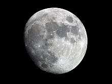
De La Rue (crater)
 Lunar Orbiter 4 image | |
| Coordinates | 59°06′N 53°00′E / 59.1°N 53.0°ECoordinates: 59°06′N 53°00′E / 59.1°N 53.0°E |
|---|---|
| Diameter | 136 km |
| Depth | Unknown |
| Colongitude | 310° at sunrise |
| Eponym | Warren de la Rue |
De La Rue is the remnant of a lunar impact crater, or possibly several merged craters, creating a formation sometimes called a walled plain. It lies in the northeastern part of the Moon on the near side, and so appears foreshortened due to its location. This formation lies to the north-northwest of the prominent crater Endymion, just beyond the eastern extreme of Mare Frigoris. The crater Strabo intrudes into the northern part of De La Rue's northern rim, and the smaller Thales is attached to the northwestern part of the wall.
The crater was named after Warren De la Rue, who took some of the first photos of the moon.
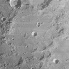
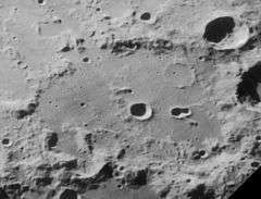
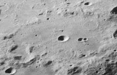
The perimeter of De La Rue is a disintegrated mass of hills, irregular ground, and notches from old craters. The rim is generally rounded along the northwest half, while a formation to the southeast intrudes into the crater resulting in a somewhat straightened wall along that flank. The overall result is a somewhat pear-shaped perimeter. There are remnants of small craters along the south-southeast rim, and several ghost-crater rims lie along the interior floor beside the northern inner wall.
Near the midpoint of the relatively flat interior floor is the bowl-shaped satellite crater De La Rue J. There is rough ground attached to the southern rim of this crater, and low hills just to the west. The inner floor is rougher along the southeast side. The remaining floor is marked by many tiny craterlets, with a notable pair in the northeast part of the interior.
Satellite craters
By convention these features are identified on lunar maps by placing the letter on the side of the crater midpoint that is closest to De La Rue.
| De La Rue | Latitude | Longitude | Diameter |
|---|---|---|---|
| D | 56.8° N | 46.2° E | 17 km |
| E | 56.8° N | 49.7° E | 32 km |
| J | 59.0° N | 52.8° E | 14 km |
| P | 60.5° N | 61.4° E | 10 km |
| Q | 61.5° N | 60.5° E | 10 km |
| R | 62.1° N | 61.1° E | 9 km |
| S | 62.9° N | 61.6° E | 12 km |
| W | 55.7° N | 46.9° E | 18 km |
References
- Wood, Chuck (2006-09-02). "A Non-Crater". Lunar Photo of the Day. Archived from the original on 2007-09-27. Retrieved 2006-09-15.
- Andersson, L. E.; Whitaker, E. A. (1982). NASA Catalogue of Lunar Nomenclature. NASA RP-1097.
- Blue, Jennifer (July 25, 2007). "Gazetteer of Planetary Nomenclature". USGS. Retrieved 2007-08-05.
- Bussey, B.; Spudis, P. (2004). The Clementine Atlas of the Moon. New York: Cambridge University Press. ISBN 978-0-521-81528-4.
- Cocks, Elijah E.; Cocks, Josiah C. (1995). Who's Who on the Moon: A Biographical Dictionary of Lunar Nomenclature. Tudor Publishers. ISBN 978-0-936389-27-1.
- McDowell, Jonathan (July 15, 2007). "Lunar Nomenclature". Jonathan's Space Report. Retrieved 2007-10-24.
- Menzel, D. H.; Minnaert, M.; Levin, B.; Dollfus, A.; Bell, B. (1971). "Report on Lunar Nomenclature by the Working Group of Commission 17 of the IAU". Space Science Reviews. 12 (2): 136–186. Bibcode:1971SSRv...12..136M. doi:10.1007/BF00171763.
- Moore, Patrick (2001). On the Moon. Sterling Publishing Co. ISBN 978-0-304-35469-6.
- Price, Fred W. (1988). The Moon Observer's Handbook. Cambridge University Press. ISBN 978-0-521-33500-3.
- Rükl, Antonín (1990). Atlas of the Moon. Kalmbach Books. ISBN 978-0-913135-17-4.
- Webb, Rev. T. W. (1962). Celestial Objects for Common Telescopes (6th revised ed.). Dover. ISBN 978-0-486-20917-3.
- Whitaker, Ewen A. (1999). Mapping and Naming the Moon. Cambridge University Press. ISBN 978-0-521-62248-6.
- Wlasuk, Peter T. (2000). Observing the Moon. Springer. ISBN 978-1-85233-193-1.