Ellisville, Wisconsin
| Ellisville, Wisconsin | |
|---|---|
| Unincorporated community | |
 Ellisville, Wisconsin  Ellisville, Wisconsin | |
| Coordinates: 44°27′28″N 87°41′03″W / 44.45778°N 87.68417°WCoordinates: 44°27′28″N 87°41′03″W / 44.45778°N 87.68417°W | |
| Country | United States |
| State | Wisconsin |
| County | Kewaunee |
| Elevation | 781 ft (238 m) |
| Time zone | UTC-6 (Central (CST)) |
| • Summer (DST) | UTC-5 (CDT) |
| Area code(s) | 920 |
| GNIS feature ID | 1564548[1] |
Ellisville is an unincorporated community located in the town of Montpelier, Kewaunee County, Wisconsin, United States. Ellisville is located at the junction of County Highways AB and F 6 miles (9.7 km) south of Luxemburg. The George Halada Farmstead, which is listed on the National Register of Historic Places, is in Ellisville.[2]
References
Municipalities and communities of Kewaunee County, Wisconsin, United States | ||
|---|---|---|
| Cities | 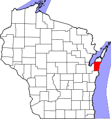 | |
| Villages | ||
| Towns | ||
| CDP | ||
| Unincorporated communities | ||
| Footnotes | ‡This populated place also has portions in an adjacent county or counties | |
This article is issued from
Wikipedia.
The text is licensed under Creative Commons - Attribution - Sharealike.
Additional terms may apply for the media files.