El Tejar, Chimaltenango
| El Tejar | |
|---|---|
| Municipality and town | |
 El Tejar Location in Guatemala | |
| Coordinates: 14°39′N 90°48′W / 14.650°N 90.800°W | |
| Country |
|
| Department |
|
| Government | |
| • Major (2016-2020) | Juan José Cua Hernández[1] |
| Time zone | UTC+6 (Central Time) |
| Climate | Cwb |
El Tejar is a municipality in the Chimaltenango department of Guatemala.
Economy
El Tejar was named for the tejas (roof tiles), bricks,and other pottery articles which are well known for their quality nationwide.
Climate
El Tejar has a subtropical highland climate (Köppen climate classification: Cwb).
| Climate data for El Tejar | |||||||||||||
|---|---|---|---|---|---|---|---|---|---|---|---|---|---|
| Month | Jan | Feb | Mar | Apr | May | Jun | Jul | Aug | Sep | Oct | Nov | Dec | Year |
| Average high °C (°F) | 22.2 (72) |
23.2 (73.8) |
24.9 (76.8) |
25.3 (77.5) |
25.1 (77.2) |
23.4 (74.1) |
23.6 (74.5) |
23.9 (75) |
23.3 (73.9) |
22.4 (72.3) |
22.5 (72.5) |
22.3 (72.1) |
23.5 (74.3) |
| Daily mean °C (°F) | 15.8 (60.4) |
16.5 (61.7) |
17.8 (64) |
19.0 (66.2) |
19.2 (66.6) |
18.7 (65.7) |
18.6 (65.5) |
18.5 (65.3) |
18.4 (65.1) |
17.5 (63.5) |
16.9 (62.4) |
15.9 (60.6) |
17.7 (63.9) |
| Average low °C (°F) | 9.4 (48.9) |
9.8 (49.6) |
10.7 (51.3) |
12.7 (54.9) |
13.4 (56.1) |
14.1 (57.4) |
13.6 (56.5) |
13.2 (55.8) |
13.5 (56.3) |
12.6 (54.7) |
11.3 (52.3) |
9.6 (49.3) |
12 (53.6) |
| Average precipitation mm (inches) | 3 (0.12) |
3 (0.12) |
3 (0.12) |
37 (1.46) |
106 (4.17) |
251 (9.88) |
184 (7.24) |
174 (6.85) |
236 (9.29) |
127 (5) |
31 (1.22) |
7 (0.28) |
1,162 (45.75) |
| Source: Climate-Data.org[2] | |||||||||||||
See also

- List of places in Guatemala
Places adjacent to El Tejar, Chimaltenango | ||||||||||
|---|---|---|---|---|---|---|---|---|---|---|
| ||||||||||
References
- ↑ "Partido UNE gana alcaldía de Chimaltenango". Prensa Libre (in Spanish). Guatemala. 8 September 2015. Retrieved 8 September 2015.
- ↑ "Climate: El Tejar". Climate-Data.org. Retrieved 20 September 2015.
- 1 2 SEGEPLAN (2010). "Municipios de Chimaltenango" (in Spanish). Guatemala. Archived from the original on 8 June 2015. Retrieved 8 June 2015.
Capital: Chimaltenango | ||
| Municipalities | 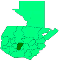 | |
This article is issued from
Wikipedia.
The text is licensed under Creative Commons - Attribution - Sharealike.
Additional terms may apply for the media files.