Sumpango, Sacatepéquez
| Sumpango | ||
|---|---|---|
 Sumpango Giant Kite Festival | ||
| ||
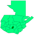
 Sumpango Location in Guatemala | ||
| Coordinates: 14°38′52″N 90°44′05″W / 14.64778°N 90.73472°W | ||
| Country |
| |
| Department | Sacatepéquez Department | |
| Area | ||
| • Total | 21 sq mi (55 km2) | |
| Elevation | 6,200 ft (1,900 m) | |
| Population (2002) | ||
| • Total | 38,770 | |
| Climate | Cwb | |

Sumpango is a town in the Guatemalan department of Sacatepéquez.
History
In the 1540s, bishop Francisco Marroquín split the ecclesiastical administration of the central valley of Guatemala between the Order of Preachers and the Franciscans, assigning Sumpango's curato to the former.[1] In 1638, the Dominicans separated their large doctrines in groups revolving around six convents:
| Convent | Doctrines or curatos | Convent | Doctrines or curatos |
|---|---|---|---|
| Guatemala |
|
Amatitlán | |
| Verapaz | |||
| Sonsonate |
| ||
| San Salvador |
|
Sacapulas |
Ecclesiastic historian Domingo Juarros wrote that in 1754, by virtue of a royal order of the enlightened absolutism of king Carlos III all curatos and doctrines of the regular clergy were moved on to the secular clergy.[3]
Giant kite festival
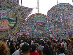
Sumpango's Festival, also known as the "Giant Kite Festival" is a cultural event that takes place on the first of November each year. On that day, people from the town gather at the soccer field near the town's cemetery to take part in a giant kite contest. Entrants have typically spent months creating their kites, and participating kites are graded on both creativity and length of flight. This contest has been around for several centuries and is now recognized as a Cultural Good of Guatemala.[4] It was also granted a Cultural Award by then president Óscar Berger Perdomo in the mid 2000s.
Climate
Sumpango has a subtropical highland climate (Köppen climate classification: Cwb).
| Climate data for Sumpango | |||||||||||||
|---|---|---|---|---|---|---|---|---|---|---|---|---|---|
| Month | Jan | Feb | Mar | Apr | May | Jun | Jul | Aug | Sep | Oct | Nov | Dec | Year |
| Average high °C (°F) | 21.1 (70) |
22.2 (72) |
23.7 (74.7) |
24.3 (75.7) |
23.8 (74.8) |
22.1 (71.8) |
22.2 (72) |
22.7 (72.9) |
21.9 (71.4) |
21.3 (70.3) |
21.4 (70.5) |
21.2 (70.2) |
22.3 (72.2) |
| Daily mean °C (°F) | 15.2 (59.4) |
15.9 (60.6) |
17.1 (62.8) |
18.2 (64.8) |
18.4 (65.1) |
17.8 (64) |
17.5 (63.5) |
17.7 (63.9) |
17.3 (63.1) |
16.7 (62.1) |
16.2 (61.2) |
15.4 (59.7) |
17 (62.5) |
| Average low °C (°F) | 9.3 (48.7) |
9.7 (49.5) |
10.6 (51.1) |
12.2 (54) |
13.0 (55.4) |
13.5 (56.3) |
12.9 (55.2) |
12.7 (54.9) |
12.8 (55) |
12.2 (54) |
11.0 (51.8) |
9.7 (49.5) |
11.6 (52.9) |
| Average precipitation mm (inches) | 6 (0.24) |
5 (0.2) |
4 (0.16) |
38 (1.5) |
122 (4.8) |
276 (10.87) |
221 (8.7) |
205 (8.07) |
260 (10.24) |
138 (5.43) |
36 (1.42) |
7 (0.28) |
1,318 (51.91) |
| Source: Climate-Data.org[5] | |||||||||||||
See also


- List of places in Guatemala
Places adjacent to Sumpango, Sacatepéquez | ||||||||||
|---|---|---|---|---|---|---|---|---|---|---|
| ||||||||||
Notes and references
References
- ↑ Juarros 1818, p. 336.
- ↑ Belaubre 2001, p. 39.
- ↑ Juarros 1818, p. 338.
- ↑ Plan de reconstrucción departamental de Sacatepéquez Archived 2010-09-11 at the Wayback Machine., p.45.
- ↑ "Climate: Sumpango". Climate-Data.org. Retrieved 19 September 2015.
- 1 2 SEGEPLAN. "Municipios de Sacatepéquez, Guatemala". Secretaría de Planificación y Programación de la Presidencia (in Spanish). Guatemala. Archived from the original on 29 June 2015. Retrieved 29 June 2015.
Bibliography
- Belaubre, Christopohe (2001). "Poder y redes sociales en Centroamérica: el caso de la Orden de los Dominicos (1757-1829)" (PDF). Mesoamérica (in Spanish). 41. Archived from the original (PDF) on 21 January 2015.
- Juarros, Domingo (1818). Compendio de la historia de la Ciudad de Guatemala (in Spanish). Guatemala: Ignacio Beteta.
- Morales, César (2010). "Historia del baile de la conquista". Iglesia de Ciudad Vieja (in Spanish). Retrieved 28 November 2014.
- Wikiguate. "Baile de la Conquista". Wikiguate (in Spanish). Archived from the original on 5 December 2014. Retrieved 28 November 2014.
External links

- Sumpango.com.gt Official city website Update In Spanish
- Official city website In Spanish