Pochuta
| Pochuta | |
|---|---|
| Municipality and town | |
 Pochuta Location in Guatemala | |
| Coordinates: 14°33′N 91°05′W / 14.550°N 91.083°W | |
| Country |
|
| Department |
|
| Government | |
| • Major (2016-2020) | Héctor R. Hernández Cumar [1] |
| Area | |
| • Total | 70 sq mi (170 km2) |
| Elevation | 3,005 ft (916 m) |
| Time zone | UTC+6 (Central Time) |
Pochuta is a municipality in the Chimaltenango department of Guatemala.
History and general information
The town was known as "San Miguel Pochuta" during the Spanish colony and was elevated to a municipality in 1921. It has an area of 170 km² and its municipal capital sits at 916 m above sea level. The main religious snnual celebrations are in September, after Michael Archangel.
Name origin
Pochuta comes from the nahuatl Pochotl or Pochotla, which means «Place of ceibas».
Geographic location
Pochuta is surrounded by Chimaltenango Department municipalities except on the west, where it borders San Lucas Tolimán, a Sololá Department municipality:[2]
Places adjacent to Pochuta | ||||||||||
|---|---|---|---|---|---|---|---|---|---|---|
| ||||||||||
See also

- List of places in Guatemala
References
- ↑ "Partido UNE gana alcaldía de Chimaltenango". Prensa Libre (in Spanish). Guatemala. 8 September 2015. Retrieved 8 September 2015.
- 1 2 3 SEGEPLAN (2010). "Municipios de Chimaltenango" (in Spanish). Guatemala. Archived from the original on 8 June 2015. Retrieved 8 June 2015.
Capital: Chimaltenango | ||
| Municipalities | 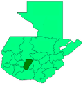 | |
This article is issued from
Wikipedia.
The text is licensed under Creative Commons - Attribution - Sharealike.
Additional terms may apply for the media files.