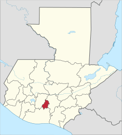
Sacatepéquez Department
| Sacatepéquez | |||
|---|---|---|---|
| Department | |||
| |||
 Sacatepéquez | |||
| Country |
| ||
| Capital | Antigua Guatemala | ||
| Municipalities | 16 | ||
| Government | |||
| • Type | Departmental | ||
| Population (Census 2002)[1][2] | |||
| • Religions | Roman Catholicism, Evangelicalism, Maya | ||
| Time zone | -6 | ||

Sacatepéquez (Spanish pronunciation: [sakateˈpekes]) is one of the 22 departments of Guatemala. Population estimate 265,500 in 2000. The name comes from Sacatepéquez, a city from November 21, 1542 until July 29, 1773 when it was destroyed by the 1773 Guatemalan Earthquake (San Martha Earthquake). Sacatepéquez means grasshill in the Pipil Maya dialect. The capital of Sacatepéquez is Antigua Guatemala which is home to an extensive textile marketplace and Plaza Major. Other important cities include Ciudad Vieja and San Lucaswhich is also hosts another popular marketplace and is a culinary attraction. The Chajoma were a group of indeginous people who were Kaqchikel speaking Indians identified Mixco Viejo as their capital, and spread throughout the Sacatepequez Department until their capital was moved to Ciudad Vieja, in Antigua.
Etymology
Sacatepéquez has also been called Zacatepeques.[3]
Population
As of 1850, the area had a population of an estimated 56,000. The southern area has the largest population, which is closer to Guatemala City.[4]
Municipalities
- Alotenango
- Antigua Guatemala
- Ciudad Vieja
- Jocotenango
- Magdalena Milpas Altas
- Pastores
- San Antonio Aguas Calientes
- San Bartolomé Milpas Altas
- San Lucas Sacatepéquez
- San Miguel Dueñas
- Santiago Sacatepéquez
- Santa Catarina Barahona
- Santa Lucía Milpas Altas
- Santa María de Jesús
- Santo Domingo Xenacoj
- Sumpango
Geography
The area is mountainous, with what the British described, in 1850, as a "mild climate."[3] Rivers include: Guacalate, Los Encuentros, Las Cañas, Pensativo y Sumpango. Guatemala is a region that is also known to be a host to a chain of active and dormant volcanoes, among the ones located in the region of Sacatepequez include Acatenago, Volcan De Agua (Volcano of Water), and Volcan de Fuego (Volcano of Fire).[5] This area is also known to host Jocotes which are Guatemala's national fruit which belongs to the cashew family albeit a fruit.[6]
Economy
The more populated areas produce fruit and various crops, including maize. Livestock is also raised, with trade going towards Guatemala City. The southern area of the department produces coffee, sugar, tobacco, and cotton. As of 1850, products were being shipped out of Iztapa.[4] Although Guatemala is able to produce cash crops such as bananas, and textiles 72% of people living in rural areas live in poverty with 31% of them reaching extreme poverty.[7]
See also
References
- ↑ "XI Censo Nacional de Poblacion y VI de Habitación (Censo 2002)". INE. 2002.
- ↑ "Comunidad Lingüística Ch'orti'". Academia de Lenguas Mayas. 2008. Archived from the original on 2016-03-15. Retrieved 2008. Check date values in:
|accessdate=(help) - 1 2 Baily, John (1850). Central America; Describing Each of the States of Guatemala, Honduras, Salvador, Nicaragua, and Costa Rica. London: Trelawney Saunders. p. 76.
- 1 2 Baily, John (1850). Central America; Describing Each of the States of Guatemala, Honduras, Salvador, Nicaragua, and Costa Rica. London: Trelawney Saunders. p. 77.
- ↑ Landmeier, Phillip. "The Volcanos of Guatemala". www.mayaparaiso.com. Retrieved 2017-05-10.
- ↑ "Guatemala's "National Fruit" – The Jocote - Qué Pasa Magazine". www.quepasa.gt. Retrieved 2017-05-10.
- ↑ Huber-Warring, Tonya (2008-01-01). Growing a Soul for Social Change: Building the Knowledge Base for Social Justice. IAP. ISBN 9781593118877.
External links

Coordinates: 14°33′24″N 90°44′02″W / 14.5566666667°N 90.7338888889°W