El Alto International Airport
| El Alto International Airport Aeropuerto Internacional El Alto | |||||||||||||||
|---|---|---|---|---|---|---|---|---|---|---|---|---|---|---|---|
 Main terminal | |||||||||||||||
| Summary | |||||||||||||||
| Airport type | Public / Military | ||||||||||||||
| Owner | Government of Bolivia | ||||||||||||||
| Operator | SABSA S.A. | ||||||||||||||
| Serves | La Paz, Bolivia | ||||||||||||||
| Location | El Alto, Bolivia | ||||||||||||||
| Hub for | |||||||||||||||
| Focus city for | |||||||||||||||
| Elevation AMSL | 4,061.5 m / 13,325 ft | ||||||||||||||
| Coordinates | 16°30′48″S 068°11′32″W / 16.51333°S 68.19222°WCoordinates: 16°30′48″S 068°11′32″W / 16.51333°S 68.19222°W | ||||||||||||||
| Website |
www | ||||||||||||||
| Map | |||||||||||||||
 LPB Location of airport in Bolivia | |||||||||||||||
| Runways | |||||||||||||||
| |||||||||||||||
| Statistics (2013) | |||||||||||||||
| |||||||||||||||
|
Source: SABSA,[1]Airport Statistics | |||||||||||||||
El Alto International Airport (Spanish: Aeropuerto Internacional El Alto) (IATA: LPB, ICAO: SLLP) is an international airport located in the city of El Alto,[2] Bolivia, 8 mi (13 km) west of La Paz.[3] At an altitude of 4,061.5 m (13,325 ft), it is the highest international airport and the fifth highest commercial airport in the world.[4]
The airport has served since the first half of the 20th century, but was modernized in the late 1960s, when its runway was lengthened and a new passenger terminal with modern facilities was built. The new airport was inaugurated in 1965.[5] El Alto airport was a primary hub for the former Lloyd Aéreo Boliviano, Bolivia's flag carrier which ceased operations in 2007 and is a hub for Transporte Aéreo Militar and Línea Aérea Amaszonas.[6] It serves also as a focus city for Boliviana de Aviación which is a state-owned airline.[7]
History


Bolivia is characterized by an extremely varied terrain including rugged mountains, high plateaus, low valleys and tropical forests; this topography has had a negative effect on national transportation, making communication difficult between elevated and low cities along with isolated tropical towns. Aviation is an important solution for isolated communities in this environment.
Bolivian air transport started in 1916, when the Military school of Aviation (Spanish: Escuela Militar de Aviación) was formed in La Paz. In 1929 the local La Paz Government first planned the construction of an airport. However it was not officially inaugurated until the 1960s. In 1974 the airport was reconstructed, a new terminal was built and its facilities were enlarged and modernized.[8] Until 1999 the airport had John F. Kennedy (JFK) as its official name although in practice this name was never publicly used. In that year, before the pressure of different sectors, by means of the Law 1944 during the government of Hugo Banzer Suárez the airport changed its name officially to El Alto International Airport.
Modernization
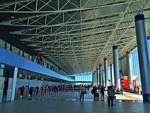
In 2006, SABSA (Spanish: Servicios Aeroportuarios Bolivianos S.A.) invested nearly 2.3 million dollars in the reconstruction of the main terminal.[9] The new terminal consists of the enlargement, reshaping and construction of the baggage claim room, the check-in area and the corridor to the air bridges. The administrative offices of AASANA as well as the main hall and the international area were completely modernized.[10]
Characteristics
The new terminal includes various shops offering Bolivian handicrafts as well as bookstores, and duty-free shops. There are also restaurants and cafes in the main lobby and in both domestic and international departure areas.
The airport has two runways: The main one "10R/28L" has a concrete surface and is 4,000 metres (13,123 ft) long, allowing large aircraft operations at higher altitudes. A second runway, "10L/28R" is located parallel to the main runway and has a grass surface. The airport is equipped with VOR/DME, DVOR/DME navigation systems, as well as ILS CAT I approach systems.
El Alto is the world's highest international airport, located at 4,062 metres (13,327 ft) above sea level. The average temperature at the airport is 6 °C (43 °F). Because of the thin high altitude air, most commercial wide-body aircraft such as the Boeing 747 and Airbus A330 cannot operate out of El Alto International Airport. As a result, much of the international traffic to and from Bolivia operates out of Viru Viru International Airport in Santa Cruz de la Sierra which is located at a much lower altitude, allowing heavy aircraft operations.
Flight testing
As one of the world's highest-altitude airports, El Alto offers features taken advantage of by aircraft manufacturers such as Airbus and Boeing to test high-altitude flights. Modern aircraft such as the Airbus A350 XWB and Boeing 787 have used El Alto to perform flight tests for their certification processes.[11][12]
Operators
From 1997, the airport was managed by TBI plc which owned concessions of the three biggest airports in the country: El Alto International Airport, Jorge Wilstermann International Airport and Viru Viru International Airport through its subsidiary Servicio de Aeropuertos Bolivianos S.A. (SABSA). In 1999 Airport Group International was purchased by TBI plc. In 2004, the company was acquired by the Spanish conglomerate Abertis, hence taking ownership of SABSA. In February 2013, the Government of Bolivia announced the nationalization of SABSA, taking full ownership and operations of Bolivia's main international gateways.[13][14]
Airlines and destinations
Notes:
Accidents and incidents
- On 14 July 1970, Douglas DC-3 TAM-17 of TAM – Transporte Aéreo Militar was damaged beyond repair in an accident.[15]
- On 4 May 1971, Douglas C-47 TAM-22 of TAM – Transporte Aéreo Militar crashed shortly after take-off on a cargo flight to El Jovi Airport.[16]
- On 17 September 1972, Douglas C-47A CP-565 of Aerolíneas Abaroa crashed on take-off. The aircraft was operating a non-scheduled passenger flight. All four people on board survived.[17]
- On 25 November 1976, Douglas C-47 CP-755 of Aerolíneas La Paz was damaged beyond economic repair in a landing accident. The aircraft was on a cargo flight, all four people on board survived.[18]
- On 1 January 1985, Eastern Air Lines Flight 980 from Asuncion hit Mount Illimani during its descent towards El Alto, killing all 29 people on board the Boeing 727-225; the flight was scheduled to continue to Lima, Guayaquil, Panama City, Miami, and Chicago.
- On 8 March 2006, a Learjet aircraft belonging to Argentina's military crashed just minutes after taking off from El Alto on its way to Viru Viru International Airport, killing all six people on board.
See also
References
- ↑ "Sabsa - Aeropuerto El Alto". Retrieved 31 October 2017.
- ↑ "El Alto - La Paz". Retrieved 31 October 2017.
- ↑ "La Paz Airport (LPB) guide to buses, taxis and trains at El Alto International Airport". www.wordtravels.com.
- ↑ "The Highest International Airport In The World - Grand Escapades". 26 October 2007.
- ↑ (in Spanish)"El Alto Airport and La Paz". Archived from the original on 26 March 2012. Retrieved 31 October 2017.
- ↑ Transporte Aéreo Militar – TAM. Hub: La Paz www.ch-aviation.ch
- ↑ "AeroSur Hub". Archived from the original on 17 March 2012.
- ↑ http://www.gobernacionlapaz.gob.bo:8001/simit/sistema/ficha_turistica/fichaturistica.php?atr_id=254%5Bpermanent+dead+link%5D
- ↑ (in Spanish) http://www.mirabolivia.com/foro_total.php?id_foro_ini=51639 Con una inversión de 2,3 millones de dólares
- ↑ (in Spanish) http://www.mirabolivia.com/foro_total.php?id_foro_ini=51639
- ↑ "A350 XWB in Bolivia for high altitude testing". www.airbus.com. 9 January 2014.
- ↑ "Boeing 787 Nears FAA Approval as Flight Tests Are Completed". www.bloomberg.com. 17 August 2011.
- ↑ "Bolivia nationalizes Spanish-owned airports operator". www.reuters.com. Reuters. Retrieved June 24, 2015.
- ↑ "Evo Morales, Bolivia President, Nationalizes Spanish-Owned Airport Company SABSA". www.thehuffingtonpost.com. The Huffington Post. Retrieved June 24, 2015.
- ↑ "TAM-17 Accident description". Aviation Safety Network. Retrieved 20 October 2010.
- ↑ "TAM-22 Accident description". Aviation Safety Network. Retrieved 19 September 2010.
- ↑ "CP-565 Accident description". Aviation Safety Network. Retrieved 7 September 2010.
- ↑ "CP-755 Accident description". Aviation Safety Network. Retrieved 15 August 2010.
External links
![]()
- Aeropuerto Internacional El Alto at SABSA website
- Weather in La Paz – El Alto Airport
- Accident history for LPB at Aviation Safety Network
| Records | ||
|---|---|---|
| Preceded by None |
World's highest airport 4,061 m (13,323 ft) 1965–1994 |
Succeeded by Qamdo Bamda Airport |