Eiderstedt (Amt)
| Eiderstedt | ||
|---|---|---|
| ||
 Eiderstedt Location of Eiderstedt within Nordfriesland district 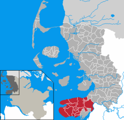 | ||
| Coordinates: 54°20′N 08°47′E / 54.333°N 8.783°ECoordinates: 54°20′N 08°47′E / 54.333°N 8.783°E | ||
| Country | Germany | |
| State | Schleswig-Holstein | |
| District | Nordfriesland | |
| Government | ||
| • Amtsvorsteher | Hans Wolff | |
| Area | ||
| • Total | 248.97 km2 (96.13 sq mi) | |
| Population (2016-12-31)[1] | ||
| • Total | 11,392 | |
| • Density | 46/km2 (120/sq mi) | |
| Time zone | CET/CEST (UTC+1/+2) | |
| Vehicle registration | NF | |
| Website | www.amt-eiderstedt.de | |

Eiderstedt (German: Eiderstedt; Danish: Ejdersted; North Frisian: Ääderstää) is an Amt ("collective municipality") in the district of Nordfriesland, in Schleswig-Holstein, Germany. The Amt covers the peninsula of Eiderstedt, excepted for the town of Tönning.
History
On January 1, 2008, the independent municipality of Sankt Peter-Ording became part of the Amt.
Subdivision
The Amt Eiderstedt consists of the following municipalities (population in 2005 between brackets):
- Garding (2,664) [town]
- Garding, Kirchspiel (344)
- Grothusenkoog (20)
- Katharinenheerd (173)
- Kotzenbüll (236)
- Norderfriedrichskoog (44)
- Oldenswort (1,282)
- Osterhever (246)
- Poppenbüll (179)
- Sankt Peter-Ording (4,177)
- Tating (990)
- Tetenbüll (610)
- Tümlauer-Koog (100)
- Vollerwiek (224)
- Welt (214)
- Westerhever (129)
Coat of arms
The coat of arms displays a golden ship on a blue background with 3 sails in which are drawn, in red, a leopard, a cow and a fish.[2]
References
External links
- (in German) Amt Eiderstedt official site
- (in German) Eiderstedt.net Eiderstedt peninsula website
- (in German) Eiderstedt peninsula website
This article is issued from
Wikipedia.
The text is licensed under Creative Commons - Attribution - Sharealike.
Additional terms may apply for the media files.