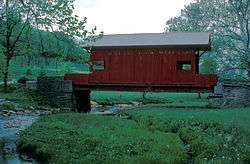
Ebenezer Covered Bridge
|
Ebenezer Covered Bridge | |
 | |
  | |
| Nearest city | Ginger Hill, Pennsylvania |
|---|---|
| Coordinates | 40°11′28″N 80°2′28″W / 40.19111°N 80.04111°WCoordinates: 40°11′28″N 80°2′28″W / 40.19111°N 80.04111°W |
| Area | 0.1 acres (0.040 ha) |
| Architectural style | Queenpost truss |
| MPS | Covered Bridges of Washington and Greene Counties TR |
| NRHP reference # | 79003829[1] |
| Added to NRHP | June 22, 1979 |
The Ebenezer Covered Bridge is a historic covered bridge in Ginger Hill, Pennsylvania. The year the bridge was built is unknown. [2]It was moved to its current location in 1977.[3]
It is designated as a historic bridge by the Washington County History & Landmarks Foundation.[4]
References
- ↑ National Park Service (2009-03-13). "National Register Information System". National Register of Historic Places. National Park Service.
- ↑ "Pennsylvania Covered Bridges". Retrieved 21 December 2017.
- ↑ "Ebenezer Covered Bridge". VisitPA.com- official tourism website of the Commonwealth of Pennsylvania. Pennsylvania Department of Community and Economic Development. Retrieved 21 December 2017.
- ↑ "Ebenezer Covered Bridge". Landmark Registry - Bridges. Washington County History & Landmarks Foundation. 2008. Retrieved 2010-11-08.
External links
| Topics |   | |
|---|---|---|
| Lists by county |
| |
| Lists by city | ||
| Other lists | ||
| ||
This article is issued from
Wikipedia.
The text is licensed under Creative Commons - Attribution - Sharealike.
Additional terms may apply for the media files.