Eastmont, Washington
| Eastmont, Washington | |
|---|---|
| CDP | |
 Eastmont, Washington Location of Eastmont, Washington. | |
| Coordinates: 47°53′51″N 122°10′24″W / 47.89750°N 122.17333°WCoordinates: 47°53′51″N 122°10′24″W / 47.89750°N 122.17333°W | |
| Country | United States |
| State | Washington |
| County | Snohomish |
| Area | |
| • Total | 5.112 sq mi (13.24 km2) |
| • Land | 5.091 sq mi (13.19 km2) |
| • Water | 0.021 sq mi (0.05 km2) |
| Population (2010) | |
| • Total | 20,101 |
| • Density | 3,948.3/sq mi (1,524.5/km2) |
| Time zone | UTC-8 (Pacific (PST)) |
| • Summer (DST) | UTC-7 (PDT) |
| GNIS feature ID | 2584969[1] |
Eastmont is a census-designated place (CDP) in Snohomish County, Washington, United States. The population was 20,101 at the 2010 census. Eastmont is one of two CDPs that were created out of the former Seattle Hill-Silver Firs CDP in 2010, the other being Silver Firs.[2] Eastmont is the location of Community Transit's Eastmont Park & Ride, which is serviced by Sound Transit Express route 513.[3]
Geography
Eastmont is located at 47°53′51″N 122°10′24″W / 47.89750°N 122.17333°W (47.897402, -122.181536).[4]
According to the United States Census Bureau, the CDP has a total area of 5.112 square miles (13.24 km²), of which, 5.091 square miles (13.19 km²) of it is land and 0.021 square miles (0.05 km²) of it (0.41%) is water.
The CDP is surrounded by the City of Everett and contains several large residential neighborhoods.
References
- ↑ "US Board on Geographic Names". United States Geological Survey. 2007-10-25. Retrieved 2008-01-31.
- ↑ "Washington: 2010 Population and Housing Unit Counts" (PDF). United States Census Bureau. Retrieved 26 February 2013.
- ↑ "Transit Centers and Parking". Community Transit. Retrieved 14 March 2013.
- ↑ "US Gazetteer files: 2010, 2000, and 1990". United States Census Bureau. 2011-02-12. Retrieved 2011-04-23.
Municipalities and communities of Snohomish County, Washington, United States | ||
|---|---|---|
| Cities | 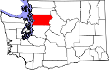 | |
| Towns | ||
| CDPs |
| |
| Other unincorporated communities | ||
| Indian reservation | ||
| Military bases | ||
| Ghost town | ||
| Footnotes | ‡This populated place also has portions in an adjacent county or counties | |