Eastern Railway (Israel)

The Eastern Railway (Hebrew: המסילה המזרחית, translit. ha-mesila ha-mizraḥit) refers to a railroad in central Israel stretching from Lod to Hadera. As of 2018, the section between Kfar Saba and Lod, as well as a short section just north of Hadera are in use, while the rest of the railway has not been operative since 1969, though there are plans to rebuild and upgrade the railway along the entire route.[1]
History
Construction
The railway was constructed by the Ottoman authorities in Palestine during the Sinai and Palestine Campaign of World War I, to assist them with moving men and materiel in the war effort. It entered service on 30 October 1915, connecting Tulkarm (where it connected to a branch line of the Jezreel Valley Railway, and through it the greater Hejaz Railway) and Lod, where it connected to the Jaffa–Jerusalem railway and the Railway to Beersheba. An extension northwards from Tulkarm to Hadera was also built in order to supply the railway with timber collected from the forests around Hadera that was used as fuel and for infrastructure. The line was built as narrow gauge (1,050 mm or 3 ft 5 11⁄32 in) like the rest of the Ottoman railways in the region and was situated relatively inland to avoid the reach of naval guns from Royal Navy warships patrolling the Mediterranean coast.
Under British administration
After the British conquered the area, they converted the railway to standard gauge and extended it from Hadera north to the port city of Haifa. It then became the main north-south rail link in the British Mandate of Palestine and was operated by Palestine Railways. While the Jaffa-Jerusalem railway was also converted to standard gauge at the same time, the Jezreel Valley Railway was not and therefore it was no longer possible for trains using the Eastern Railway to travel to sections of the Hejaz Railway due to the gauge break. During the Mandate period, stations on the Eastern Railway operated in Hadera, Qaqun, Tulkarm, Qalqilyah, Rosh HaAyin, Rantiya, Kafr Jinis, and Lydda (Lod). In the later stages of World War II and for a short time thereafter, the Eastern Railway was one link in a larger contiguous standard gauge rail network that allowed trains to travel all the way from Anatolia to southern Egypt.
State of Israel
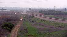
When the State of Israel was established in 1948, most of the line lay within its borders, except for a small section of railway near Tulkarm. In 1949 a bypass was constructed west of Tulkarm which allowed renewal of service on the railway. In 1953, Israel Railways completed constructing the Coastal Railway from Hadera to Tel Aviv on a route roughly paralleling the Eastern Railway's, but much closer to the coastline, where most of the population resides. Nevertheless, some passenger and freight service on the Eastern railway continued operating, partly to show Israeli presence in the region around the railway which lay very close to the Green Line – then the country's eastern border. The railway also derived its name from this easterly location within the country. After Israel came to control both sides of the Green Line following the 1967 Six-Day War, service on the section of the line from just south of the Hadera East Railway Station to Kfar Saba was discontinued in 1969, with that railway section effectively abandoned and is nowadays dismantled.
The rest of the line between Kfar Saba and Lod continued operating, albeit mainly for freight services, with a few passenger trains making use of the section between Rosh HaAyin and Lod to reach southern Israel from northern Tel Aviv and points north (since until the 1990s, the Ayalon Railway did not exist and thus there was no north-south rail connection through Tel Aviv itself – therefore making this section the only link between the northern and southern portions of Israel's rail network). In the early 2000s, the Kfar Saba–Rosh HaAyin section was rebuilt and double tracked and now forms part of the suburban railway line serving cities in the southern Sharon plain.
Another part of the Eastern Railway that continued operating is a short section which connects the Hadera East Railway Station to the Coastal Railway at a point near Pardes Hanna named Remez Junction, though since 1969 Hadera East, now a terminal station, is only used for handling freight trains bound for the adjacent Granot "Ambar North" large feed mill complex.
Plans
Partly to alleviate congestion on the Coastal Railway as well as to increase freight capacity on the national rail network and provide rail access to a planned inland port, the government of Israel has announced plans to revive the old Eastern line at a projected cost of NIS 8 billion (appx. US$2.2 billion).[1] The proposed project involves rebuilding the railroad in the Hadera – Kfar Saba section and upgrading the existing section between Kfar Saba and Lod, including the construction of 30 grade separations, ten other supporting structures, and connections and flying junctions with other railroads. The entire route will be double-tracked and stations will be constructed or rebuilt in Hadera, Ahituv (formerly Qaqun), Tayibe, Kokhav Ya'ir, Kfar Saba (East), El'ad, and Te'ufa (near the old Kafr Jinis station and today's Airport City business park). A significant portion of the railway will be built alongside the existing Cross-Israel Highway. Construction however is not expected to take place before 2020. In 2018, the National Roads Company began acquiring land necessary for the project.[2]
References
- 1 2 Tischler, Tzvika (15 September 2016). "עולים על המסילה" [Eastern Railway On Track]. Yedioth Ahronoth (in Hebrew). Retrieved 16 September 2016.
- ↑ https://www.calcalist.co.il/real_estate/articles/0,7340,L-3737113,00.html
| Intercity and suburban rail lines | |
|---|---|
| Other/freight- only lines | |
| Urban rail lines | |
| Smart cards | |
| Roads |
| ||||
|---|---|---|---|---|---|
| Bus operators | |||||
| Rail transport |
| ||||
| Sea ports | |||||
| Aviation |
| ||||
| Cable cars | |||||
| By city | |||||
| Smart cards | |||||
Coordinates: 32°9′0.06″N 34°56′7.8″E / 32.1500167°N 34.935500°E