Akmola Region
| Akmola Region Ақмола облысы (Kazakh) Акмолинская область (Russian) | ||
|---|---|---|
| Region | ||
 The center of Kokshetau | ||
| ||
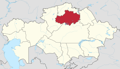 Map of Kazakhstan, location of Akmola Region highlighted | ||
| Coordinates: 52°0′N 69°0′E / 52.000°N 69.000°ECoordinates: 52°0′N 69°0′E / 52.000°N 69.000°E | ||
| Country |
| |
| Capital | Kokshetau | |
| Government | ||
| • Akim | Malik Murzalin | |
| Area[1] | ||
| • Total | 146,219 km2 (56,455 sq mi) | |
| Population (2017-06-01)[2] | ||
| • Total | 715,000 | |
| • Density | 4.9/km2 (13/sq mi) | |
| Time zone | UTC+6 | |
| • Summer (DST) | UTC+6 (not observed) | |
| Postal codes | 020000 | |
| Area codes | +7 (717) | |
| ISO 3166 code | KZ-AKM | |
| Vehicle registration | 03, C | |
| Districts | 17 | |
| Cities | 8 | |
| Townships | 14 | |
| Villages | 671 | |
| Website |
akmo | |
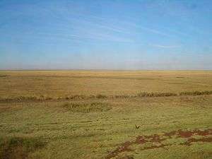
Akmola Region (Kazakh: Ақмола облысы, translit. Aqmola oblysy; Russian: Акмолинская область, tr. Akmolinskaya oblast') is a centrally located region of Kazakhstan. Its capital is Kokshetau. The national capital, Astana, is enclosed by the region, but is politically separate from Akmola Region. The region's population is 715,000; Kokshetau's is 157,000. The area is 146,200 square kilometers. It and Karaganda Region are Kazakhstan's only two regions which don't touch the country's outer borders. Akmola Region borders North Kazakhstan Region in the north, Pavlodar Region in the east, Karagandy Region in the south, and Kostanay Region in the west. Some gold and coal mining occur in the area.
Etymology
Aqmola in Kazakh language means the white burial.
Demographics
Ethnic Kazakhs account for 53.4% of the population in the 2017 census, compared to 33.7% for Russians.[3]
Administrative divisions
The region is administratively divided into seventeen districts and the cities of Kokshetau and Stepnogorsk.[4]
- Akkol District, with the administrative center in the town of Akkol;
- Arshaly District, the settlement of Arshaly;
- Astrakhan District, selo of Astrakhanka;
- Atbasar District, the town of Atbasar;
- Bulandy District, the town of Makinsk;
- Burabay District, the town of Shchuchinsk;
- Egindikol District, the selo of Egindikol;
- Enbekshilder District, the town of Stepnyak;
- Ereymentau District, the town of Ereymentau;
- Esil District, the town of Esil;
- Korgalzhyn District, the selo of Korgalzhyn;
- Sandyktau District, the selo of Balkashino;
- Shortandy District, the settlement of Shortandy;
- Tselinograd District, the selo of Akmol;
- Zerendi District, the selo of Zerendi;
- Zhaksy District, the settlement of Zhaksy;
- Zharkain District, the town of Derzhavinsk.
* The following ten localities in Akmola Region have town status:[4] Akkol, Atbasar, Derzhavinsk, Ereymentau, Esil, Kokshetau, Makinsk, Shchuchinsk, Stepnogorsk, and Stepnyak.
Notable residents
- David Rigert, weightlifter, Olympic champion, 5x world champion (light-heavyweight and heavyweight), 68 world records.
External links
| Wikimedia Commons has media related to Aqmola Region. |
References
- ↑ "Official site - General Information". Archived from the original on 2008-01-19. Retrieved 2008-01-14.
- ↑ Agency of statistics of the Republic of Kazakhstan: Численность населения Республики Казахстан по областям с началa 2013 года до 1 февраля 2013 года (russisch; Excel-Datei; 55 kB).
- ↑ ru:Акмолинская область
- 1 2 Акиматы районов, г. Петропавловска (in Russian). Официальный интернет-ресурс Северо-Казахстанской области. Retrieved 23 June 2012.
Places adjacent to Akmola Region | |
|---|---|
Capital: Kokshetau | ||
| Districts |  | |
| Major cities | ||