East Hampton Village District
|
East Hampton Village District | |
 "Home Sweet Home" | |
  | |
| Location |
Bounded by Main St. and James and Woods Lanes, (original) Northeastward along Main St. to Newton La. and Southwestward along Ocean and Lee Aves. and Pond La. to Hedges La., (increase), East Hampton, New York |
|---|---|
| Coordinates | 40°57′17″N 72°11′28″W / 40.95472°N 72.19111°WCoordinates: 40°57′17″N 72°11′28″W / 40.95472°N 72.19111°W |
| Architect | J.C. Thorp |
| Architectural style | Late 19th And 20th Century Revivals, Bungalow/Craftsman, Late Victorian |
| MPS | Village of East Hampton MRA |
| NRHP reference # |
74001309 (original) 88001032 (increase)[1] |
| Added to NRHP |
May 2, 1974 (original) July 21, 1988 (increase)[1] |
East Hampton Village District is a historic district in East Hampton, New York.[2][3]
It was listed on the National Register of Historic Places in 1974 and its boundaries were increased in 1988.[1]
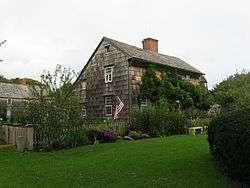
It includes the John Howard Payne House (a.k.a.; "Home Sweet Home") and the Thomas Moran House, which is a National Historic Landmark.
It includes the Pantigo Windmill and the Gardiner mill, two of the east end's New England style smock windmills. Starting at the 1926 flagpole on the village green, there is a large rock with a plaque in front of it. The Green behind slopes up to the South End Cemetery, which was also the site of the Town Church. It was a thatched roofed structure that is no longer there, right about where it stood is a large memoriam to Lion Gardiner, whose grave is 30 feet away. There is a historical marker at the side of James Lane for the church and another for the church is at Pondview Lane, opposite the flagpole. Further along is the town pond. This oval constitutes the original site, it was expanded to include; on the other side of James Lane from the flagpole, Tuthill House, Mulford Farmhouse, Home Sweet Home of Thomas Payne, St. Luke's Episcopal Church and Rectory, the saltbox replica that was installed recently, Gardiner Mill, The Rev. Thomas James historical marker- first pastor of the town church, (1661-1692) and the Thomas Moran House. The trees on that side of the street by Mulford homestead are all separately markered with a stone with a name/date shield.[4][5][6][7][8]
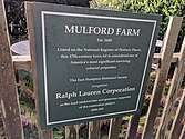 Mulford Farm in East Hampton
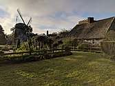 English colonial farmsteads, the Pantigo Windmill abuts the farm.
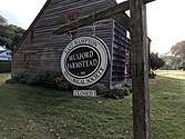 Mulford Farm colonial farmsteads.
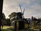 Farm in East Hampton, Long Island
_6913.jpg) Pantigo Windmill
Pantigo Windmill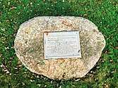 NRHP contributing structures and markers on the green
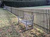 Mulford Farm seats
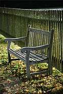 An arbor of trees line the street with memorial markers and contemplation benches.
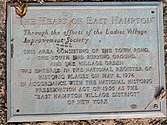 Mulford Farm in East Hampton is Landmarked
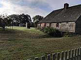 Mulford Farm Privy is in center/left
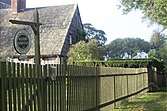 Home Sweet Home Museum
 NRHP contributing structures on the green
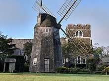 NRHP Pantigo Mill and St Lukes church
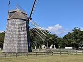 Gardiner Mill
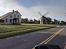 NRHP contributing structures and Gardiner mill
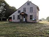 Saltbox replica
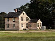 Rear view
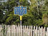 NRHP contributing structures and markers on the green
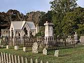 South End Cemetery
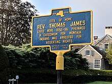 Rev Thomas James, First pastor
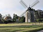 Gardiner Mill
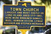 Town Church HM
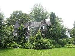 Thomas Moran House, a U.S. National Historic Landmark
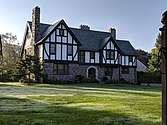 NRHP St. Lukes Rectory
 NRHP contributing structures and markers on the green, tree marker
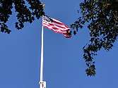 “This Flag Pole dedicated to the Village of East Hampton in memory of George Lodowick McAlpin, 1856-1922, by members of his family, July 4, 1926.” — Plaque.
References
- 1 2 3 National Park Service (2008-04-15). "National Register Information System". National Register of Historic Places. National Park Service.
- ↑ Lynn Beebe Weaver (November 1973). "National Register of Historic Places Registration: East Hampton Village District". New York State Office of Parks, Recreation and Historic Preservation. Retrieved 2011-09-29.
- ↑ Mark Peckham (August 1987). "National Register of Historic Places Registration: East Hampton Village District (Boundary Increase)". New York State Office of Parks, Recreation and Historic Preservation. Retrieved 2011-09-29. See also: "Accompanying 108 photos".
- ↑ http://www.aaqeastend.com/contents/landmarks/gardiner-mill-1804-east-hampton/
- ↑ http://www.easthamptonvillage.org/DocumentCenter/View/132/The-Historic-Preservation-of-the-Village-of-East-Hampton-PDF?bidId=
- ↑ https://ehamptonny.gov/DocumentCenter/View/675/Gardiner-PDF
- ↑ http://www.aaqeastend.com/contents/portfolio/preservation-tours-portfolio/east-hampton-main-street-historic-district-walking-tour-east-side-new-5-10-13/
- ↑ https://millhouseinn.com/easthampton-2/
External links
![]()
- Amagansett Historic Sites and East Hampton Village Historic District (East Hampton Chamber of Commerce)
- East Hampton Historical Society
| Topics | |
|---|---|
| Lists by states |
|
| Lists by insular areas | |
| Lists by associated states | |
| Other areas | |
| |