Earth radius
| Earth radius | |
|---|---|
 13th century illustration of Earth in De sphaera mundi. | |
| Unit information | |
| Unit system | astronomy, geophysics |
| Unit of | distance |
| Symbol | R⊕ or , |
| Unit conversions | |
| 1 R⊕ in ... | ... is equal to ... |
| SI base unit | 6.3781×10⁶ m[1] |
| Metric system | 6353 to 6384 km |
| English units | 3,948 to 3,967 mi |


Earth radius is the approximate distance from Earth's center to its surface, about 6,371 km (3,959 mi). This distance is used as a unit of length, especially in astronomy and geophysics, where it is usually denoted by R⊕. Strictly speaking, the term "radius" is a property of a true sphere. Since Earth is only approximately spherical, no single value serves as its definitive radius. Meaningful values range from 6,353 to 6,384 kilometres (3,948 to 3,967 mi).
A distance from the center of Earth to some point on its surface might be referred to as Earth’s radius at that point. More commonly, Earth radius means a computed average of distances to the surface or to some idealized surface. The idealized surface is usually mean sea levels globally or else an ellipsoid that approximates sea level.[lower-alpha 1] If elevations were to be included, average radius would increase by about 230 m over sea level, or less than one part in 25,000.[2]
The first published reference to the Earth's size appeared around 350 BC, when Aristotle reported in his book On the Heavens[3] that mathematicians had guessed the circumference of the Earth to be 400,000 stadia. Scholars have interpreted Aristotle's figure to be anywhere from highly accurate[4] to almost double the true value.[5] The first known scientific measurement and calculation of the radius of the Earth was performed by Eratosthenes in about 240 BC. Estimates of the accuracy of Eratosthenes’s measurement range from 0.5% to 17%.[6] For both Aristotle and Eratosthenes, uncertainty in the accuracy of their estimates is due to modern uncertainty over which stadion length they meant.
Introduction
Earth's rotation, internal density variations, and external tidal forces cause its shape to deviate systematically from a perfect sphere.[lower-alpha 2] Local topography increases the variance, resulting in a surface of profound complexity. Our descriptions of Earth's surface must be simpler than reality in order to be tractable. Hence, we create models to approximate characteristics of Earth's surface, generally relying on the simplest model that suits the need.
Each of the models in common use involve some notion of the geometric radius. Strictly speaking, spheres are the only solids to have radii, but broader uses of the term radius are common in many fields, including those dealing with models of Earth. The following is a partial list of models of Earth's surface, ordered from exact to more approximate:
- The actual surface of Earth
- The geoid, defined by mean sea level at each point on the real surface[lower-alpha 3]
- A spheroid, also called an ellipsoid of revolution, geocentric to model the entire Earth, or else geodetic for regional work[lower-alpha 4]
- A sphere
In the case of the geoid and ellipsoids, the fixed distance from any point on the model to the specified center is called "a radius of the Earth" or "the radius of the Earth at that point".[lower-alpha 5] It is also common to refer to any mean radius of a spherical model as "the radius of the earth". When considering the Earth's real surface, on the other hand, it is uncommon to refer to a "radius", since there is generally no practical need. Rather, elevation above or below sea level is useful.
Regardless of the model, any radius falls between the polar minimum of about 6,357 km and the equatorial maximum of about 6,378 km (3,950 to 3,963 mi). Hence, the Earth deviates from a perfect sphere by only a third of a percent, which supports the spherical model in many contexts and justifies the term "radius of the Earth". While specific values differ, the concepts in this article generalize to any major planet.
Physics of Earth's deformation
Rotation of a planet causes it to approximate an oblate ellipsoid/spheroid with a bulge at the equator and flattening at the North and South Poles, so that the equatorial radius a is larger than the polar radius b by approximately aq. The oblateness constant q is given by

where ω is the angular frequency, G is the gravitational constant, and M is the mass of the planet.[lower-alpha 6] For the Earth 1/q ≈ 289, which is close to the measured inverse flattening 1/f ≈ 298.257. Additionally, the bulge at the equator shows slow variations. The bulge had been decreasing, but since 1998 the bulge has increased, possibly due to redistribution of ocean mass via currents.[8]
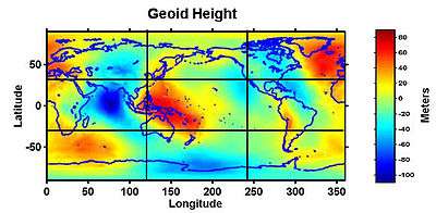
The variation in density and crustal thickness causes gravity to vary across the surface and in time, so that the mean sea level differs from the ellipsoid. This difference is the geoid height, positive above or outside the ellipsoid, negative below or inside. The geoid height variation is under 110 m (360 ft) on Earth. The geoid height can change abruptly due to earthquakes (such as the Sumatra-Andaman earthquake) or reduction in ice masses (such as Greenland).[9]
Not all deformations originate within the Earth. The gravity of the Moon and Sun cause the Earth's surface at a given point to undulate by tenths of meters over a nearly 12-hour period (see Earth tide).
Radius and local conditions
Given local and transient influences on surface height, the values defined below are based on a "general purpose" model, refined as globally precisely as possible within 5 m (16 ft) of reference ellipsoid height, and to within 100 m (330 ft) of mean sea level (neglecting geoid height).
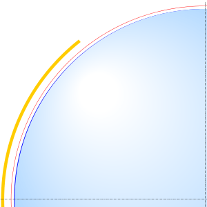
Additionally, the radius can be estimated from the curvature of the Earth at a point. Like a torus, the curvature at a point will be greatest (tightest) in one direction (north–south on Earth) and smallest (flattest) perpendicularly (east–west). The corresponding radius of curvature depends on the location and direction of measurement from that point. A consequence is that a distance to the true horizon at the equator is slightly shorter in the north/south direction than in the east-west direction.
In summary, local variations in terrain prevent defining a single "precise" radius. One can only adopt an idealized model. Since the estimate by Eratosthenes, many models have been created. Historically, these models were based on regional topography, giving the best reference ellipsoid for the area under survey. As satellite remote sensing and especially the Global Positioning System gained importance, true global models were developed which, while not as accurate for regional work, best approximate the Earth as a whole.
Fixed radius
The following radii are fixed and do not include a variable location dependence. They are derived from the World Geodetic System 1984 (WGS-84) standard ellipsoid.[10]
The value for the equatorial radius is defined to the nearest 0.1 m in WGS-84. The value for the polar radius in this section has been rounded to the nearest 0.1 m, which is expected to be adequate for most uses. Refer to the WGS-84 ellipsoid if a more precise value for its polar radius is needed.
The radii in this section are for an idealized surface. Even the idealized radii have an uncertainty of ±2 m.[11] The discrepancy between the ellipsoid radius and the radius to a physical location may be significant. When identifying the position of an observable location, the use of more precise values for WGS-84 radii may not yield a corresponding improvement in accuracy.
The symbol given for the named radius is used in the formulae found in this article.
Equatorial radius
The Earth's equatorial radius a, or semi-major axis, is the distance from its center to the equator and equals 6,378.1370 km (3,963.1906 mi).[12] The equatorial radius is often used to compare Earth with other planets.
Polar radius
The Earth's polar radius b, or semi-minor axis, is the distance from its center to the North and South Poles, and equals 6,356.7523 km (3,949.9028 mi).
Location-dependent radii
Geocentric radius
The distance from the Earth's center to a point on the spheroid surface at geodetic latitude φ is:

where a and b are, respectively, the equatorial radius and the polar radius.
Notable geocentric radii
- Maximum: The summit of Chimborazo is 6,384.4 km (3,967.1 mi) from the Earth's center.
- Minimum: The floor of the Arctic Ocean is approximately 6,352.8 km (3,947.4 mi) from the Earth's center.[13]
Radii of curvature
Principal sections
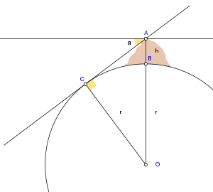
There are two principal radii of curvature: along the meridional and prime-vertical normal sections.
Meridional
In particular, the Earth's radius of curvature in the (north–south) meridian at φ is:

This is the radius that Eratosthenes measured.
Prime vertical
If one point had appeared due east of the other, one finds the approximate curvature in the east–west direction.[lower-alpha 7]
This radius of curvature in the prime vertical which is perpendicular (normal or orthogonal) to M at geodetic latitude φ is:[lower-alpha 8]

This radius is also called the transverse radius of curvature. At the equator, N = R.
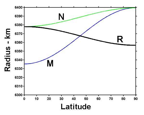
The Earth's meridional radius of curvature at the equator equals the meridian's semi-latus rectum:
- b2/a = 6,335.439 km
The Earth's polar radius of curvature is:
- a2/b = 6,399.594 km
Directional
The Earth's radius of curvature along a course at an azimuth (measured clockwise from north) α at φ is derived from Euler's curvature formula as follows:[14]:97

Combinations
It is possible to combine the principal radii of curvature above in a non-directional manner.
The Earth's Gaussian radius of curvature at latitude φ is:[14]

The Earth's mean radius of curvature at latitude φ is:[14]:97

Global average radii
The Earth can be modeled as a sphere in many ways. This section describes the common ways. The various radii derived here use the notation and dimensions noted above for the Earth as derived from the WGS-84 ellipsoid;[10] namely,
- a = Equatorial radius (6378.1370 km)
- b = Polar radius (6356.7523 km)
A sphere being a gross approximation of the spheroid, which itself is an approximation of the geoid, units are given here in kilometers rather than the millimeter resolution appropriate for geodesy.
Mean radius

In geophysics, the International Union of Geodesy and Geophysics (IUGG) defines the mean radius (denoted R1) to be[15]

For Earth, the mean radius is 6,371.0088 km (3,958.7613 mi).[16]
In astronomy, the International Astronomical Union denotes the nominal equatorial Earth radius as , which is defined to be 6,378.1 km (3,963.2 mi).[1]:3 The nominal polar Earth radius is defined as = 6,356.8 km (3,949.9 mi). These values correspond to the zero tide radii. Equatorial radius is conventionally used as the nominal value unless the polar radius is explicitly required.[1]:4

Authalic radius
Earth's authalic ("equal area") radius is the radius of a hypothetical perfect sphere that has the same surface area as the reference ellipsoid. The IUGG denotes the authalic radius as R2.[15]
A closed-form solution exists for a spheroid:[17]

where e2 = a2 − b2/a2 and A is the surface area of the spheroid.
For the Earth, the authalic radius is 6,371.0072 km (3,958.7603 mi).[16]
Volumetric radius
Another spherical model is defined by the volumetric radius, which is the radius of a sphere of volume equal to the ellipsoid. The IUGG denotes the volumetric radius as R3.[15]
![{\displaystyle R_{3}={\sqrt[{3}]{a^{2}b}}\,.}](../I/m/ef606031ae7a1ba9f55d4d71b5926c79968a0aac.svg)
For Earth, the volumetric radius equals 6,371.0008 km (3,958.7564 mi).[16]
Rectifying radius
Another mean radius is the rectifying radius, giving a sphere with circumference equal to the perimeter of the ellipse described by any polar cross section of the ellipsoid. This requires an elliptic integral to find, given the polar and equatorial radii:

The rectifying radius is equivalent to the meridional mean, which is defined as the average value of M:[17]

For integration limits of [0,π/2], the integrals for rectifying radius and mean radius evaluate to the same result, which, for Earth, amounts to 6,367.4491 km (3,956.5494 mi).
The meridional mean is well approximated by the semicubic mean of the two axes,

which differs from the exact result by less than 1 μm (4×10⁻⁵ in); the mean of the two axes,

about 6,367.445 km (3,956.547 mi), can also be used.
Average distance from center to surface
Most global mean radii are based on the reference ellipsoid, which approximates the geoid. The geoid has no direct relationship with surface topography, however. An alternative calculation averages elevations everywhere, resulting in a mean radius 230 m larger than the IUGG mean radius, the authalic radius, or the volumetric radius. This average is 6,371.230 km (3,958.899 mi) with uncertainty of 10 m (33 ft).[2]
Osculating sphere
The best spherical approximation to the ellipsoid in the vicinity of a given point is given by the osculating sphere. Its radius equals the Gaussian radius of curvature as above, the center of the sphere is located at the center of curvature of the ellipsoid, and its radial direction coincides with the ellipsoid normal direction. This concept aids the interpretation of terrestrial and planetary radio occultation refraction measurements.
See also
- Earth mass
- Effective Earth radius
- Geodesy
- Geographical distance
- History of geodesy
- Template:Earth radius
Notes
- ↑ See Figure of Earth for a more complete discussion of the models.
- ↑ For details see figure of the Earth, geoid, and Earth tide.
- ↑ There is no single center to the geoid; it varies according to local geodetic conditions.
- ↑ In a geocentric ellipsoid, the center of the ellipsoid coincides with some computed center of Earth, and best models the earth as a whole. Geodetic ellipsoids are better suited to regional idiosyncrasies of the geoid. A partial surface of an ellipsoid gets fitted to the region, in which case the center and orientation of the ellipsoid generally do not coincide with the earth's center of mass or axis of rotation.
- ↑ The value of the radius is completely dependent upon the latitude in the case of an ellipsoid model, and nearly so on the geoid.
- ↑ This follows from the International Astronomical Union definition rule (2): a planet assumes a shape due to hydrostatic equilibrium where gravity and centrifugal forces are nearly balanced.[7]
- ↑ East–west directions can be misleading. Point B, which appears due east from A, will be closer to the equator than A. Thus the curvature found this way is smaller than the curvature of a circle of constant latitude, except at the equator. West can be exchanged for east in this discussion.
- ↑ N is defined as the radius of curvature in the plane that is normal to both the surface of the ellipsoid at, and the meridian passing through, the specific point of interest.
References
- 1 2 3 Mamajek, E. E; Prsa, A; Torres, G; et al. (2015). "IAU 2015 Resolution B3 on Recommended Nominal Conversion Constants for Selected Solar and Planetary Properties". arXiv:1510.07674 [astro-ph.SR].
- 1 2 Frédéric Chambat; Bernard Valette (2001). "Mean radius, mass, and inertia for reference Earth models" (PDF). Physics of the Earth and Planetary Interiors. 124. pp. 234–253. Retrieved 18 November 2017.
- ↑ Aristotle. On the Heavens. Book II 298 B. Retrieved 5 November 2017.
- ↑ Drummond, William (1817). "On the Science of the Egyptians and Chaldeans, Part I". The Classical Journal. 16: 159.
- ↑ "Figure of the Earth". Encyclopædia Britannica. 1911.
- ↑ "Eratosthenes, the Greek Scientist". Encyclopædia Britannica. 2016.
- ↑ IAU 2006 General Assembly: Result of the IAU Resolution votes Archived 2006-11-07 at the Wayback Machine.
- ↑ Satellites Reveal A Mystery Of Large Change In Earth's Gravity Field , Aug. 1, 2002, Goddard Space Flight Center. Archived April 28, 2010, at the Wayback Machine.
- ↑ NASA's Grace Finds Greenland Melting Faster, 'Sees' Sumatra Quake, December 20, 2005, Goddard Space Flight Center.
- 1 2 http://earth-info.nga.mil/GandG/publications/tr8350.2/wgs84fin.pdf
- ↑ http://earth-info.nga.mil/GandG/publications/tr8350.2/tr8350.2-a/Chapter%203.pdf
- ↑ "Equatorial Radius of the Earth". Numerical Standards for Fundamental Astronomy: Astronomical Constants : Current Best Estimates (CBEs). IAU Division I Working Group. 2012. Retrieved 2016-08-10.
- ↑ "Discover-TheWorld.com - Guam - POINTS OF INTEREST - Don't Miss - Mariana Trench". Guam.discover-theworld.com. 1960-01-23. Archived from the original on 2012-09-10. Retrieved 2013-09-16.
- 1 2 3 "Geodesy". google.com.br.
- 1 2 3 Moritz, H. (1980). Geodetic Reference System 1980, by resolution of the XVII General Assembly of the IUGG in Canberra.
- 1 2 3 Moritz, H. (March 2000). "Geodetic Reference System 1980". Journal of Geodesy. 74 (1): 128–133. Bibcode:2000JGeod..74..128.. doi:10.1007/s001900050278.
- 1 2 Snyder, J.P. (1987). Map Projections – A Working Manual (US Geological Survey Professional Paper 1395) p. 16–17. Washington D.C: United States Government Printing Office.
External links
- Merrifield, Michael R. (2010). " The Earth's Radius (and exoplanets)". Sixty Symbols. Brady Haran for the University of Nottingham.
