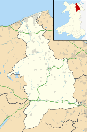
Dyserth
Dyserth
| |
|---|---|
 Dyserth Church | |
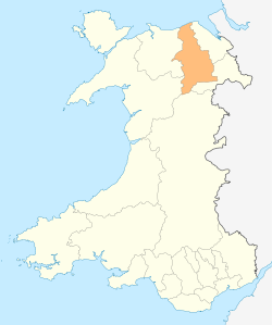
 Dyserth Dyserth shown within Denbighshire | |
| Population | 2,269 (2011) |
| OS grid reference | SJ056789 |
| Community |
|
| Principal area | |
| Country | Wales |
| Sovereign state | United Kingdom |
| Post town | RHYL |
| Postcode district | LL18 |
| Dialling code | 01745 |
| Police | North Wales |
| Fire | North Wales |
| Ambulance | Welsh |
| EU Parliament | Wales |
| UK Parliament | |
| Welsh Assembly | |
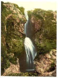
Dyserth (Welsh: Diserth) is a village, community and electoral ward in Denbighshire, Wales. Population: 2,566 (United Kingdom Census 2001), falling to 2,269 at the 2011 census.[1] Its main features are the extensive quarrying remains, its waterfalls, railway line (former London and North Western Railway, closed in 1930, and now footpath), and mountain (Moel Hiraddug).
Overview
It has a long history and is mentioned in the Domesday book of 1086 as follows, it being at the time listed under Cheshire:[2]
| “ |
Ad hoc manerium ROELENT jacent hae berewiches, DISSAREN BODUGAN CHILVEN et MAENEVAL. In his est terra i carrucata tantum et silva i leuva longa et dimidia lata. Ibi est francigena et ii villani habent i caracutas.
|
” |
Dyserth also had a nearby castle, which suffered at the hands of Llywelyn ap Gruffudd; destroyed after a six-week siege in 1263. The remains of the castle were quarried away during World War I.
The oldest industry in the village and surrounding area is mining, with lead, copper and limestone just some of the minerals being mined locally in the past. These quarries are still visible and form a major part of the village's geography, though mining ceased when Dyserth Quarry closed in 1981.
Traditionally, there has been a very strong Welsh language speaking community in the village and until recent times many families and village folk knew, or knew of, each other. This is typical of a rural community whose life often centred on the many churches and chapels in the village. Many of the village's families have their roots in agriculture, with many notable farms in or around Dyserth; these include Hottia, Bryn Cnewyllyn and Ty Newydd.
A recent drive to reawaken a feeling of village pride has had some success, due in part to the heavy promotion of Dyserth people, and village-based events and organisations. In addition, the excellent work of some village folk in securing the sprucing up of parts of the village, notably the High Street, parks and entrances to Dyserth has been welcome. The village has a large number of active community and environmental organisations some with a long history (for example the Dyserth & District Field Club founded in 1911).
It has also recently received a grant from the National Lottery Heritage Lottery Fund to refurbish the community hall which has proven a great success in the rejuvenation of the village.
St Bridget's Church
The village church is dedicated to Brigit of Kildare. It is believed that the Celtic monk Cwyfan founded a place of worship near the Dyserth Waterfall. Later the church became dedicated to Bridget. The church is notable for its Jesse Window, dating from the 16th century. The church's sister parishes are the villages of Trelawnyd and Cwm. the vicar is Canon Robert Rowland.[3]
Railway
The Dyserth branch line was opened by the London and North Western Railway in 1869 to tap limestone quarries and a lead mine. A passenger, parcels and goods service was introduced in 1905 serving local needs and the north coast of Wales' booming holiday industry. The company designed and built a single carriage, steam-powered Motor Train for such lines, with the Dyserth Branch using the first example.[4][5] The passenger service was a success before the First World War, with services having to be doubled and an additional unit provided for the motor trains. After the war the motor trains were replaced by locomotive-propelled push-pull trains.[6] Road competition and the 1926 General Strike ate into profits, leading the London, Midland and Scottish Railway to withdraw the passenger service in 1930.[4]
The line remained open for minerals, parcels and general goods until the end of November 1951, when parcels and general goods traffic ended, leaving just coal to Dyserth and limestone products from a quarry in that village. Coal traffic ended in May 1964, with lime and limestone traffic continuing until the line officially closed completely on 7 September 1973,[7][8] but at least two special trains took stone away in 1974.
The tracks were lifted in 1980,[9] with the former trackbed now converted into a mixed-use path and horse track.
References
- ↑ "Ward/community population 2011". Retrieved 23 May 2015.
- ↑ http://www.domesdaybook.co.uk/cheshire3.html
- ↑
- 1 2 Rear 2003, p. 51.
- ↑ Goodall 2003, pp. 60-64.
- ↑ Rear 2003, p. 47.
- ↑ Mitchell & Smith 2011, Plate 120.
- ↑ "Visit Prestatyn – Railway Line History". Visit Prestatyn.
- ↑ Rear 2003, p. 48.
External links
| Wikimedia Commons has media related to Dyserth. |
- http://www.dyserth.com
- Journal newspaper covering Dyserth
- Geograph (photos of Dyserth and surrounding area)