Berwyn range


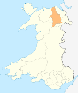
The Berwyn range (Welsh: Y Berwyn or Mynydd y Berwyn) is an isolated and sparsely populated area of moorland in the northeast of Wales, roughly bounded by Llangollen in the northeast, Corwen in the northwest, Bala in the southwest, and Oswestry in the southeast.
Description
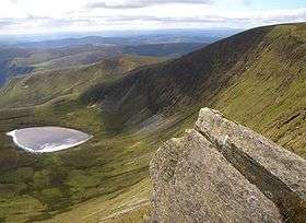
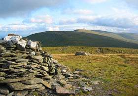
The area is wild and largely vegetated by heather about one metre thick, with some acidic grassland and bracken. It is not very popular for hill-walking or scrambling since the peaks are lower than those in nearby Snowdonia. However, the topmost peaks are rugged and have a distinctive character well worth exploring. Nearby towns include Llangollen and Corwen, which are popular tourist destinations.
The main summits are Cadair Berwyn at 832 metres (2,730 ft) above sea level, Moel Sych at 827 metres (2,713 ft) and Cadair Bronwen at 784 metres (2,572 ft) above sea level. The Berwyn range is crossed to the south-west by the B4391 Milltir Cerrig mountain pass at an altitude of 486 metres (1,594 ft).
Cadair Berwyn is the highest point in the Berwyn range, and the highest significant summit in Wales outside the National Parks. Cadair Bronwyn and Cyrniau Nod to the west are the two Marilyns that form the Berwyn range.
The mountain lies on main ridge of the Berwyn range which runs north–south. The eastern side of the ridge is characterised by steep drops and crags including Craig Berwyn north of the summit and Craig y Llyn to the south. Craig y Llyn forms the headwall of a cwm, and it is to this that the word cadair (chair in Welsh) presumably refers. Further north along the ridge is Cadair Bronwen, whilst to south the ridge continues to Moel Sych (Welsh pronunciation: [ˈmɔil ˈsɨːx], meaning 'dry hill').
It is often reported that Moel Sych, 1 kilometre (0.6 mi) along the ridge, is of equal height, but Cadair Berwyn's spot height on the Ordnance Survey maps, where the trig point stands, is not the true summit. Cadair Berwyn's summit, 200 metres (219 yd) south of the trig point, is three metres taller than Moel Sych. This summit is listed as Cadair Berwyn New Top on the Nuttall list.
Several other summits in the area are listed as Hewitts or Nuttalls, including Foel Wen ([ˈvɔil ˈwɛn], Welsh for white hill) and Mynydd Tarw ([ˈmɐnɨð ˈtæɾu], bull mountain).
The summit lies on the border between Powys and Denbighshire, and is the highest point in Denbighshire. The northern end of Craig Berwyn is the highest point in Wrexham county borough.
History
There is a standing stone in the area, located near the summit between Cadair Berwyn and Tomle. This was re-erected in June 2008 by High Sports. The standing stone can be found at SJ080337[2].
The Berwyn range also played its part in causing King Henry II of England to turn back during his invasion of Gwynedd in 1165. Rather than taking the usual route along the northern coastal plain, his army invaded from Oswestry and took a route over the Berwyns. The English invasion faced an alliance of Welsh princes led by King Owain Gwynedd, but there was little fighting – endless days of heavy rain forced the English to retreat.
Supposed UFO crash
At 8.38 pm on 23 January 1974, an earthquake of magnitude 3.5 was felt over a wide area of north Wales and as far as Liverpool. Since earthquakes are uncommon in the UK, it was not generally recognized for what it was, and since a number of unusual lights in the sky had been observed the same evening, it was considered possible that an aircraft had crashed, or a meteorite had impacted. Further confusion was caused by lights seen on the Berwyn Mountains, which subsequently turned out to have belonged to poachers.[1]
Ecology
The area supports substantial populations of upland birds including raptors, such as the hen harrier (Circus cyaneus), merlin (Falco columbarius), and peregrine (Falco peregrinus) (about 14–18 breeding pairs of each species, 1%–2% of the total British population),[2] and for this reason it is a Special Protection Area classified in accordance with the European Union's Birds Directive. Much of the area is also designated a national nature reserve and a Site of Special Scientific Interest and forms part of the Berwyn and South Clwyd Mountains Special Area of Conservation.[3] Other wildlife include short-eared owl, raven, buzzard, polecat and golden plover.
Etymology
The scholar T. Gwynn Jones suggested that a possible origin of the term "Berwyn" was "Bryn(iau) Gwyn (ap Nudd)", where the Middle Welsh word "bre" (hill) had mutated to Ber + Gwyn, Gwyn ap Nudd being the mythological King of the Tylwyth Teg (Fair Folk, or fairies).[4] A more likely etymology is "bar" (summit, crest) + "gwyn" (white)[5], with the "a" in "bar" showing i-affection as a result of the "y" in "gwyn", therefore changing from "a" to "e"; the word also shows soft mutation of the letter "g" (which is deleted under soft mutation).
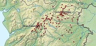
Peaks
| Name of Peak | OS coordinates | Geographical coordinates | |
|---|---|---|---|
| Allt y Gader | SJ149176 | 52.749°N, 3.262°W | |
| Allt y Main | SJ162151 | 52.727°N, 3.242°W | |
| Bryn Du | SJ145360 | 52.914°N, 3.272°W | |
| Bryn Gwyn | SJ042295 | 52.854°N, 3.424°W | |
| Bryn-llus | SJ085408 | 52.956°N, 3.363°W | |
| Cadair Berwyn | SJ071323 | 52.880°N, 3.381°W | |
| Cadair Berwyn (N top) | SJ072327 | 52.883°N, 3.380°W | |
| Cadair Bronwen | SJ077346 | 52.900°N, 3.373°W | |
| Cadair Bronwen (NE top) | SJ087352 | 52.906°N, 3.358°W | |
| Carnedd Das Eithin | SJ051238 | 52.803°N, 3.409°W | |
| Cefn Coch | SH923266 | 52.826°N, 3.599°W | |
| Cefn Gwyntog | SH976265 | 52.826°N, 3.521°W | |
| Cefn Gwyntog (N top) | SH975274 | 52.834°N, 3.522°W | |
| Cerrig Coediog | SJ113386 | 52.937°N, 3.321°W | |
| Craig Berwyn | SJ077335 | 52.891°N, 3.373°W | |
| Craig Rhiwarth | SJ054271 | 52.833°N, 3.405°W | |
| Croes y Forwyn | SJ029210 | 52.777°N, 3.440°W | |
| Cyrniau | SJ062251 | 52.815°N, 3.393°W | |
| Cyrniau Nod | SH988279 | 52.839°N, 3.503°W | |
| Cyrniau y Llyn | SJ000244 | 52.807°N, 3.484°W | |
| Ffordd Gefn (Bryn Gwyn) | SJ033240 | 52.804°N, 3.435°W | |
| Foel Cwm Siân Llwyd | SH995313 | 52.869°N, 3.494°W | |
| Foel Dugoed | SH893131 | 52.704°N, 3.639°W | |
| Foel Figenau | SH916284 | 52.842°N, 3.610°W | |
| Foel Goch (Berwyn) | SH943290 | 52.848°N, 3.570°W | |
| Foel Tyn-y-fron | SH918257 | 52.817°N, 3.606°W | |
| Foel Wen | SJ099333 | 52.889°N, 3.340°W | |
| Foel Wen (S peak) | SJ102330 | 52.886°N, 3.336°W | |
| Foel y Geifr | SH937275 | 52.834°N, 3.579°W | |
| Gallt y Goedhwch | SJ137159 | 52.733°N, 3.279°W | |
| Glan Hafon | SJ080272 | 52.834°N, 3.367°W | |
| Godor | SJ094307 | 52.866°N, 3.347°W | |
| Godor (N top) | SJ089311 | 52.869°N, 3.354°W | |
| Gyrn Moelfre | SJ184293 | 52.854°N, 3.213°W | |
| Jericho Hill | SJ162202 | 52.772°N, 3.243°W | |
| Llanymynech Hill | SJ263221 | 52.791°N, 3.094°W | |
| Lledwyn Mawr | SH905287 | 52.844°N, 3.627°W | |
| Moel Bentyrch | SJ055095 | 52.674°N, 3.399°W | |
| Moel Cae-howel | SH978330 | 52.884°N, 3.520°W | |
| Moel Fferna | SJ116397 | 52.947°N, 3.317°W | |
| Moel Hen-fache | SJ109281 | 52.843°N, 3.324°W | |
| Moel Poethion | SJ082306 | 52.865°N, 3.365°W | |
| Moel Sych | SJ066318 | 52.875°N, 3.389°W | |
| Moel y Fronllwyd | SJ121176 | 52.748°N, 3.303°W | |
| Moel y Gwelltyn | SJ170277 | 52.840°N, 3.233°W | |
| Moel yr Ewig | SJ080317 | 52.874°N, 3.368°W | |
| Moel yr Henfaes | SJ077385 | 52.935°N, 3.374°W | |
| Moel yr Henfaes (Pen Bwlch Llandrillo peak) | SJ089369 | 52.921°N, 3.356°W | |
| Moel yr Henfaes (W peak) | SJ099374 | 52.926°N, 3.341°W | |
| Mynydd Feifod | SJ169400 | 52.950°N, 3.238°W | |
| Mynydd Mawr | SJ132286 | 52.847°N, 3.290°W | |
| Mynydd Mynyllod | SJ002395 | 52.943°N, 3.486°W | |
| Mynydd Tarw | SJ112324 | 52.881°N, 3.321°W | |
| Mynydd y Bryn | SJ217268 | 52.833°N, 3.163°W | |
| Mynydd y Glyn | SJ153222 | 52.790°N, 3.257°W | |
| Mynydd-y-briw | SJ174260 | 52.825°N, 3.227°W | |
| Pen y Berth | SJ081127 | 52.704°N, 3.361°W | |
| Pen y Boncyn Trefeilw | SH962283 | 52.842°N, 3.542°W | |
| Pen y Cerrig Duon | SH953281 | 52.840°N, 3.555°W | |
| Pen-y-coed | SJ226414 | 52.964°N, 3.153°W | |
| Post Gwyn | SJ048293 | 52.852°N, 3.415°W | |
| Rhialgwm | SJ055211 | 52.779°N, 3.402°W | |
| Rhiwaedog-uwch-afon | SH938313 | 52.868°N, 3.579°W | |
| Rhos | SJ125323 | 52.881°N, 3.301°W | |
| Rhwng y Ddwynant | SH978248 | 52.811°N, 3.517°W | |
| Stac Rhos | SH969279 | 52.838°N, 3.532°W | |
| Tir Rhiwiog | SH929162 | 52.732°N, 3.587°W | |
| Tomle | SJ085335 | 52.891°N, 3.361°W | |
| Trum y Gwrgedd | SH941284 | 52.842°N, 3.573°W | |
| Y Golfa | SJ182070 | 52.654°N, 3.210°W | |
| Y Groes Fagl | SH988290 | 52.848°N, 3.504°W | |
| Yr Allt | SJ242102 | 52.684°N, 3.122°W | |
References
- ↑ Roberts, Andy (2001). "The Berwyn Mountain UFO Crash – A British Roswell?". Flying Saucery Presents ... The Real UFO Project. Retrieved 12 October 2009.
- ↑ "Berwyn". Joint Nature Conservation Committee. Retrieved 29 June 2011.
- ↑ Countryside Council for Wales. "Berwyn". Retrieved 16 March 2014.
- ↑ T. Gwynn Jones, Welsh Folklore and Folk-Custom (1930; new edition 1979). Several other place names in the area also include the element 'Gwyn'.
- ↑ D. Geraint Lewis, Y Llyfr Enwau – Enwau'r Wlad: A check-list of Welsh Place Names (2007).