Drabiv
| Drabiv Драбів | ||
|---|---|---|
| ||
| Country |
| |
| Oblast | Cherkasy Oblast | |
| Raion | Drabiv Raion | |
| Founded | 1680 | |
| Government | ||
| • Chairman of the raion council | Osadchyy Ivan Vasylovych | |
| Area | ||
| • Total | 18.019 km2 (6.957 sq mi) | |
| Elevation | 121 m (397 ft) | |
| Population | 6,508 (2,017) | |
| Time zone | UTC+2 (EET) | |
| • Summer (DST) | UTC+3 (EEST) | |
| Postal code | 19800 — 19805 | |
| Area code(s) | +38 04738 | |
| Website | http://oblrada.ck.ua/drabiv/index.htm | |

Drabiv (Ukrainian: Драбів) is an urban-type settlement located in Cherkasy Oblast (province) in the central Ukraine. It is the administrative center of Drabiv Raion (district). Population: 6,508 (2017 est.)[1]
Town located in the upper reaches of the Zolotonoshka river, tributary of the Dnipro river, 75 kilometres (47 mi) from the regional center town – Cherkasy, 12 kilometres (7.5 mi) from Drabovo-Bariatynske railway station.
History
The first written mention about Drabiv was made in 1680th year, when rich cossack and later Pereyaslav Colonel Ivan Myrovych had taken lands with small khutir, (which was there for a long time before) from a free military steppe on the river Zolotonoshka. Myrovych appealed to Czar to issue him a deed for ownership of the estate. In 1691 he received the deed on the khutir with pond, forest, pastures and hayfields. In 1707 khutir consisted of 7 houses. During the Northern war Ivan Myrovych's son – Fedir Myrovych, together with Mazepa joined the Swedish side. After Sweden's defeat, in accordance with the decree issued by Peter I in 1718, all estates of Myrovych’s family, including khutir Drabiv were transferred to duke Kantakuzen.
In 1738 the widow of Kantakuzen handed over Drabiv to the Czar's treasury. In 1775 Catherine II granted Drabiv into the eternal and hereditary possession of count Peter Zavadovsky. In 1843 Zavadovsky family sold Drabiv to Baryatynsky. In 1848 Drabiv was granted the status of a market town, it becomes the volost center with 4700 residents.
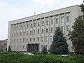 Drabiv Local Administration
References
- ↑ "Чисельність наявного населення України (Actual population of Ukraine)" (in Ukrainian). State Statistics Service of Ukraine. Retrieved 26 August 2017.
External links
Coordinates: 49°57′45″N 32°08′59″E / 49.962406°N 32.149683°E
| Raions | |||||
|---|---|---|---|---|---|
| Cities |
| ||||
| |||||