Langdon, Kent
| Langdon | |
|---|---|
 St Augustine's Parish Church, Langdon | |
 Langdon Langdon shown within Kent | |
| Population | 558 (2011)[1] |
| Civil parish |
|
| District | |
| Shire county | |
| Region | |
| Country | England |
| Sovereign state | United Kingdom |
| Post town | Dover |
| Dialling code | 01304 |
| Police | Kent |
| Fire | Kent |
| Ambulance | South East Coast |
| EU Parliament | South East England |
Langdon is a village and civil parish near Dover in Kent, England. It was the site of West Langdon Abbey which was dissolved in 1535.[2] Langdon is also more commonly referred to as East Langdon.
History
The word Langdon comes from the original Old English meaning, 'Long Down' or 'Long Hill'. The name 'Langdon' is an Anglo-Saxon origin and one of the oldest names recorded. It is a common surname, as well as a locational name from places in Devon, Dorset, Warwickshire, Essex and Kent. However, East and West Langdon in Kent is the earliest recorded use of the place name Langdon, at the time of the 861 Saxon Charters the place was recorded as "Langandune".[3] The original meaning of Langdon suggests that the parish lies along a 'long hill' or 'long down' between Deal and Whitfield.[4]
In the west of Langdon, the remains of the historical Langdon Abbey lie. Founded in 1198 by Sir William de Auberville of Westhangerand and dissolved in 1535.
Historic England describes how the Premonstratensian abbey remains:
'The abbey buildings survive partly as ruins incorporated within a later house, Listed Grade II*, and also within the Grade II Listed, north eastern wall of a 19th century agricultural barn. Elsewhere, the abbey survives in buried form and as earthworks.'[5]
In the 1870s, Langdon was described as:
LANGDON (EAST), a village and a parish in Dover district, Kent. The village stands near the Deal and Dover railway, 3½ miles NNE of Dover. The parish contains also the hamlet of Marten; and its post-town is Dover. Acres, 1,065. Real property, £2,228. Pop., 362. Houses, 72. The property is divided among a few. The living is a rectory in the diocese of Canterbury. Value, £126. * Patron, the Earl of Guilford. The church comprises nave, small aisle, and chancel.[6]
Village
Langdon is a civil parish as well as a village, the parish consists of the four hamlets:- East Langdon, West Langdon, Martin and Martin Mill, the population of Langdon therefore includes these hamlets.[4] Langdon is located 4.6 miles north east of Dover.[7]
Services
There is a small local post office in the village, open Tuesday and Thursday 9am-12pm, offering a few key services to the local public including services in mail, identity and licences, travel, driving and finances.[8] The village has a small primary school called Langdon Primary School, in the 2016 Ofsted report there was a total of 78 students.[9]
Transport
Despite Langdon being in a remote location, there is a local bus serving the area, the number 93 bus stops at East Langdon, Martin and Martin Mill and can be used to travel into Dover and Deal.[10] In Langdon, there is a local train station in the hamlet of Martin Mill. A train from Martin Mill Railway Station to Dover costs just £3.70 for a return ticket.[11] This station can also be used to get a direct train to London St Pancras International station, open return tickets start at £36 with two trains running every hour.[12]
Churches
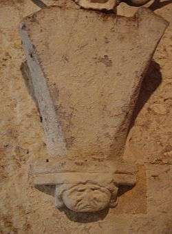
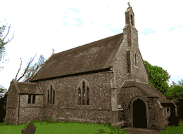
St Augustine's Church

St Augustine's Church is a medieval church located in the east of Langdon, the church is dedicated to Saint Augustine and is a grade II listed building. It was completed in the 12th century by the Normans, however, has since had some additions and a north porch added to it between the 14th and 16th century. In the late 19th century, a Victorian architect Loftus Brock restored parts of the church, mainly doing work on the tower.[13]
John E Vigar describes St Augustine's Church:
'Standing high over its picturesque village, St Augustine’s is a little-visited gem. In origin a Norman church with original north doorway, it was rescued from neglect in the late nineteenth century. Inside the chancel is much higher than the nave and contains good stained glass by Powell. The narrow south aisle houses the odd font – octagonal with wild carvings set on a crude Victorian base that looks as though it was made for somewhere else and brought here as an afterthought. In a case is a rare medieval cope, delightfully embroidered with the Annunciation, and use as the basis for one of the altar frontals. A large Royal Arms, fragments of medieval glass and what is probably the best hourglass stand in Kent, make this a church to remember.'[14]
In the 1851 census there are some details on St Augustine's church, the average morning service attendance was 151 people however the total seating capacity was just 121, suggesting that at the time it was popular to attend morning services in Langdon. At St Augustine's there was only a morning service not an afternoon or evening one.[14]
St Mary the Virgin's Church
In the west of Langdon there is another small church, St Mary's, dedicated to Saint Mary the Virgin. It is said that the church was built by Monks in the early 12th century, near the site of Langdon Abbey. However, in the 16th century when Langdon Abbey was dissolved, this led to the church being neglected and in need of restoration. Attempts were made to repair the church by Sir Thomas Peyton in 1660.[15]
Memorials
Both St Augustine's and St Mary's Church have war memorials in memory of those from the parish who lost their lives fighting in the First World War and the Second World War. The number of people who lost their lives during the First World War is higher compared to those who lost their lives in the Second World War.[16]
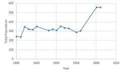
Population

According to the 2011 Census there were 281 males and 277 females living in Langdon.[17] The population time series of Langdon from 1801 to 2011 shows how the population fluctuated over the years between 1801 and 1961.[18] In more recent years the population appears to have levelled off at almost 560 in 2001 and 2011.[17]
.png)
1881 Occupations
In 1881 the total population of Langdon was 307.[19] At the time the occupations of the residents were predominantly in agriculture with 70 people, mainly male, working in this economic sector. Looking at maps from the 19th century of Langdon they show that the area was mainly rural which may suggest why there was a high number of jobs in the agricultural sector. Other occupations for men during this time period included; Carpentry, mechanic, platelayer, railway labourer, a career in the navy or a blacksmith. Women during this time were mainly engaged in domestic offices and services such as indoor servants, charwomen or worked for a washing and bathing service, a total of 10 females were working in this type of employment.[20]
2011 Economic Activity
In the 2011 census data, it was recorded that 424 residents aged 16–74 were employed.[21] The number of women engaging in economic activity has significantly increased since 1881, in 2011 a total of 216 women were in employment.[22] The number of males engaging in economic activity in 2011 was 208, employment between males and females in Langdon is now very similar, compared to the 1881 statistics where economic activity was mainly dominated by males.[23]
References
- ↑ "Parish population 2011". Retrieved 4 October 2015.
- ↑ "Pastscape, Langdon Abbey". Historic England. Historic England. Retrieved 27 February 2017.
- ↑ "Last Name: Langdon". The Internet Surname Database. The Internet Surname Database. Retrieved 23 March 2017.
- 1 2 "Kent Parishes, Landon Parish Council". Langdon Parish Council. Langdon Parish Council. Retrieved 14 March 2017.
- ↑ "Premonstratensian monastery and associated fishponds at West Langdon". Historic England. Historic England. Retrieved 23 March 2017.
- ↑ Wilson, John Marius (1870–72). Imperial Gazetteer of England and Wales. Edinburgh: A. Fullerton & co.
- ↑ "Langdon to Dover in miles, Google Maps". Google Maps. Google. Retrieved 17 March 2017.
- ↑ "Branch Finder, Langdon". The Post Office. The Post Office. Retrieved 19 March 2017.
- ↑ "Welcome to Langdon Primary School, Ofsted Reports". Langdon Primary School. Langdon Primary School. Retrieved 19 March 2017.
- ↑ "Bus routes and maps, Kent". Kent County Council. Kent County Council. Retrieved 16 March 2017.
- ↑ "Train prices from Martin Mill, Langdon to Dover". Southeastern Trains. Southeastern Trains. Retrieved 16 March 2017.
- ↑ "Train prices and times from Martin Mill Station to London". Southeastern Trains. Southeastern Trains. Retrieved 16 March 2017.
- ↑ "The History of Kent, History of East Langdon". Kent Past. Kent Past. Retrieved 23 March 2017.
- 1 2 Vigar, John. "St Augustine East Langdon". John E Vigar's Kent Churches. Kent Churches. Retrieved 23 March 2017.
- ↑ "The History of Kent, History of West Langdon". Kent Past. Kent Past. Retrieved 23 March 2017.
- ↑ "East and West Langdon, Church war memorials". The Dover War Memorial Project. The Dover War Memorial Project. Retrieved 23 March 2017.
- 1 2 "Langdon: Key Figures for 2011 Census: Key Statistics". Neighbourhood Statistics. Office for National Statistics. Retrieved 2 February 2017.
- ↑ "East Langdon CP/AP through time | Population Statistics | Population Change". A Vision of Britain through Time. GB Historical GIS / University of Portsmouth. Retrieved 28 February 2017.
- ↑ "East Langdon CP/AP through time | Population Statistics | Total Population". A Vision of Britain through Time. GB Historical GIS | University of Portsmouth,. Retrieved 28 February 2017.
- ↑ "East Langdon CP/AP | 1881 Census Table | Occupation of Males and Females". A Vision of Britain through Time. GB Historical GIS / University of Portsmouth. Retrieved 28 February 2017.
- ↑ "Economic Activity, 2011, Langdon (Parish)". Neighbourhood Statistics. Office for National Statistics. Retrieved 12 April 2017.
- ↑ "Economic Activity, Females 2011, Langdon (Parish)". Neighbourhood Statistics. Office of National Statistics. Retrieved 12 April 2017.
- ↑ "Economic Activity, males 2011, Langdon (Parish)". Neighbourhood Statistics. Office for National Statistics. Retrieved 12 April 2017.