Douala
| Douala | |
|---|---|
 Douala | |
 Douala Map of Cameroon showing the location of Douala | |
| Coordinates: 04°03′N 009°41′E / 4.050°N 9.683°E | |
| Country |
|
| Region | Littoral |
| Department | Wouri |
| Government | |
| Area | |
| • Total | 210 km2 (80 sq mi) |
| Elevation | 13 m (43 ft) |
| Population (2012 (est.)) | |
| • Total | 2,446,945[1] |
| Time zone | UTC+1 (WAT) |
| • Summer (DST) | UTC+1 (WAT) |
| Website | Official website |
Douala (German: Duala) is the largest city in Cameroon and its economic capital. It is also the capital of Cameroon's Littoral Region. Home to Central Africa's largest port and its major international airport, Douala International Airport (DLA), it is the commercial and economic capital of Cameroon and the entire CEMAC region comprising Gabon, Congo, Chad, Equatorial Guinea, Central African Republic and Cameroon. Consequently, it handles most of the country's major exports, such as oil, cocoa and coffee, timber, metals and fruits. As from 2018, the city and its surrounding area had an estimated population of 1,338,082.[2] The city sits on the estuary of Wouri River and its climate is tropical.
Settlements had already existed in present-day Douala prior to the arrival of the Portuguese, British, and Germans; however, it was during the German colonization that the city began to develop rapidly as a commercial and political hub of the German colonial administration. During World War I a bitter battle was fought for control of Douala. The city surrendered to British and French forces on September 27, 1914. A joint Anglo-French condominium governed the city until a comprehensive agreement ceded it (and much of Cameroon) to the French. After the independence of Cameroon in 1960, Douala grew rapidly. Local industries, trade, and other opportunities have attracted an unprecedented influx of migrants, especially from the western region of Cameroon. People from other countries in the region have also permanently settled in the city; they include Nigerians, Chadians, and Malians. In recent times city authorities have been overwhelmed by rapidly increasing population; services are stretched and there is an urgent need to enhance the city's ability to cope with the rapid growth.
History
The first Europeans to visit the area were the Portuguese in about 1472. At the time, the estuary of Wouri River was known as the Rio dos Camarões. By 1650, it had become the site of a town formed by immigrants, said to have arrived from Congo, who spoke the Duala language. During the 18th century it was the center of the transatlantic slave trade.
In 1826[3] Douala appeared to be made of four different villages located in four specific locations: the village of Deido (Dido), of Akwa, of Njo and Hickory-town (today Bonaberi, located on the other side of Wouri River).
%2C_Kamerun%2C_Dezember_1884.jpg)
Between 1884 and 1895 the city was a German protectorate. The colonial politics focused on commerce and some exploration of the unoccupied territories. In 1885, Alfred Saker organized the first mission of the British Baptist Church. In the same year the city known as Kamerun was renamed Douala and became the capital of the territory until 1902, when the capital was moved to Buéa.
In 1907 the Ministry of Colonies was established and Douala had 23,000 citizens.[4]
After World War I in 1919, the German colonial territories became French and British protectorates. France received a mandate to administer Douala. A treaty was signed with the local chiefs.
From 1940 to 1946, it was the capital of Cameroon. In 1955 the city had over 100,000 inhabitants.[4]
In 1960 Cameroon became independent and it became a federal republic, with its capital in Yaoundé. Douala became the major economic city. In 1972 the federal republic became a unified state. Douala then had a population of around 500,000.[4]
In the 1980s, in Cameroon the struggle for liberalization and multi-partitism grew. Between May and December 1991, Douala was at the center of the civil disobedience campaign called the ghost town operation (ville morte) during which economic activities shut down to make the country ungovernable and to force the government to allow multi-partitism and freedom of expression.[5]
Name
With the arrival of the Portuguese in the 15th century, the area was known as Rio dos Camarões. Before coming under German rule in 1884,[6] the town was also known as Cameroons Town; thereafter it became Kamerunstadt ("Cameroon City"), the capital of German Kamerun. It was renamed Douala in 1907 after the name of the natives known as Dua ala Ijaws (Njos), and became part of the French Cameroons in 1919. Many of the Ijaw (Njo) natives migrated to the Niger Delta in Nigeria during the Portuguese era.
Geography
_02.jpg)
The city is located on the banks of Wouri River, the two sides linked by Bonaberi Bridge. In 2013, President Paul Biya made a decree that a new bridge would be built over Wouri River to accommodate the growing population of the citizens in Douala. The bridge is still under construction.
Climate
Douala features a tropical monsoon climate (Köppen climate classification Am), with relatively consistent temperatures throughout the course of the year, though the city experiences somewhat cooler temperatures in July and August. Douala typically features warm and humid conditions with an average annual temperature of 27.0 °C (80.6 °F) and an average humidity of 83%.[7][8] Douala sees plentiful rainfall during the course of the year, experiencing on average roughly 3,600 millimetres (140 in) of precipitation per year.[7] Its driest month is December, when on average 28 millimetres (1.1 in) of precipitation falls, while its wettest month is August, when on average nearly 700 millimetres (28 in) of rain falls.[7]
| Climate data for Douala (1971–2000, extremes 1885–present) | |||||||||||||
|---|---|---|---|---|---|---|---|---|---|---|---|---|---|
| Month | Jan | Feb | Mar | Apr | May | Jun | Jul | Aug | Sep | Oct | Nov | Dec | Year |
| Record high °C (°F) | 35.8 (96.4) |
39.8 (103.6) |
37.8 (100) |
36.4 (97.5) |
36.0 (96.8) |
39.0 (102.2) |
32.5 (90.5) |
32.0 (89.6) |
33.1 (91.6) |
35.0 (95) |
38.0 (100.4) |
38.0 (100.4) |
39.8 (103.6) |
| Average high °C (°F) | 32.2 (90) |
32.8 (91) |
32.5 (90.5) |
32.1 (89.8) |
31.4 (88.5) |
29.9 (85.8) |
28.1 (82.6) |
27.7 (81.9) |
29.0 (84.2) |
29.8 (85.6) |
30.9 (87.6) |
31.7 (89.1) |
30.7 (87.3) |
| Daily mean °C (°F) | 27.8 (82) |
28.5 (83.3) |
28.2 (82.8) |
27.8 (82) |
27.3 (81.1) |
26.5 (79.7) |
25.4 (77.7) |
25.3 (77.5) |
25.9 (78.6) |
26.2 (79.2) |
27.1 (80.8) |
27.5 (81.5) |
27.0 (80.6) |
| Average low °C (°F) | 23.4 (74.1) |
24.1 (75.4) |
23.9 (75) |
23.5 (74.3) |
23.2 (73.8) |
23.0 (73.4) |
22.7 (72.9) |
22.8 (73) |
22.8 (73) |
22.5 (72.5) |
23.2 (73.8) |
23.3 (73.9) |
23.2 (73.8) |
| Record low °C (°F) | 18.0 (64.4) |
19.0 (66.2) |
18.0 (64.4) |
18.3 (64.9) |
16.0 (60.8) |
18.2 (64.8) |
18.2 (64.8) |
19.0 (66.2) |
18.5 (65.3) |
16.8 (62.2) |
18.5 (65.3) |
18.0 (64.4) |
16.0 (60.8) |
| Average precipitation mm (inches) | 34.2 (1.346) |
54.5 (2.146) |
155.2 (6.11) |
241.2 (9.496) |
276.2 (10.874) |
354.1 (13.941) |
681.4 (26.827) |
687.5 (27.067) |
561.2 (22.094) |
406.6 (16.008) |
123.1 (4.846) |
27.5 (1.083) |
3,602.7 (141.839) |
| Average precipitation days (≥ 0.1 mm) | 5 | 9 | 15 | 18 | 21 | 23 | 27 | 30 | 26 | 24 | 12 | 5 | 215 |
| Average relative humidity (%) | 80 | 79 | 80 | 81 | 82 | 85 | 87 | 88 | 86 | 84 | 83 | 82 | 83 |
| Mean monthly sunshine hours | 193.3 | 179.1 | 171.9 | 176.5 | 175.8 | 123.1 | 72.0 | 53.2 | 90.8 | 131.2 | 162.1 | 184.2 | 1,713.2 |
| Source #1: World Meteorological Organization[7] Meteo Climat (record highs and lows)[9] | |||||||||||||
| Source #2: Deutscher Wetterdienst (humidity, 1957–1990),[8] NOAA (sun, 1961–1990)[10] | |||||||||||||
Population
Evolution of population in Douala (in thousands)
| Year | 1916 | 1920 | 1924 | 1927 | 1931 | 1933 | 1935 | 1937 | 1939 | 1941 |
| Population | 29,4 | 26,4 | 44,5 | 54,6 | 37 | 52,6 | 56,5 | 79,4 | 69,8 | 76,7 |
| Year | 1944 | 1947 | 1949 | 1954 | 1956 | 1976 | 1987 | 1991 | 1999 |
| Population | 73,8 | 115,5 | 77,6 | 192,4 | 224,3 | 637 | 810 | 884 | 1448,3 |
With 1,9 million inhabitants in 2005, Douala is the most populated city of Cameroon.
Languages
Cameroon is home to nearly 250 languages or dialects.[11] French and English are official languages, but Douala is primarily francophone. In 2014, 63,7 % of Douala inhabitants of over 15 years know how to read and write French, while 76,4% know how to speak and understand French.[12]
Urbanism and contemporary life
The city of Douala is divided into seven districts (Akwa, Bassa, Bonabéri, Bonapriso, Bonanjo, Deïdo and New Bell)[13] and it has more than 120 neighborhoods.
Some of the neighborhoods of Douala include
- Akwa. Akwa is Douala's business district and Bonanjo its administrative district. Plateau Joss is the name used historically for the current district of Akwa. The name of the districts refer to the Douala lineage, as well as the neighborhoods. For example, Akwa was historically divided between Bell and Deido into Bonadibong, Bonamilengue, Boneleke, Bonalembe, Bonejang, Bonamuti, Bonabekombo, Bonaboijan, and Bonakuamuang; the prefix "bona" means "descendant of".
- Bali, housing area located near Bonanjo administrative area.
- Bépanda is one of the popular neighbourhood with lots of inhabitants coming from West Africa
- Deido is a historical neighborhood
- Bonaberi is located on the right of Wouri River. It is primarily an industrial neighborhood, connected by the unique bridge of the city. It is also the main opening toward the western anglophone area of the country
- Bonapriso is a rather wealthy housing neighbourhood
- Bonanjo is the administrative neighborhood, with many large administrations, larger companies and banks offices, with higher buildings than the rest of the city
- Bonamoussadi is a housing area
- Kotto is a modern neighborhood
- New Bell is another historical suburb
- Bassa
Main sights
According to Jacques Soulillou,[14] historical images of Douala document the areas of Akwa (Plateau Joss) and the port between 1860 and 1960, while the districts of Bonaberi, Deido and New Bell have almost no images. The archives which provide documentation about the city are based in Paris,[15] Basel,[16] Hamburg,[17] Potsdam,[18] Douala[19] and Yaoundé.[20]
The Native Baptist Church was built in 1849. In 1896 a first urban plan of the city was developed during the German colonial period. The plan included a hospital, the governor residency, the palace of justice, the police station, administrative buildings and buildings for the port and customs (among those the Old Woermann Linie Bachelors House). The Bonakouamouang Chimney also dates back to this period. In 1904 construction of the Villa Mandessi Bell was begun. In 1905 the palace of the King Manga Ndumbe Bell (also called la Pagode) was built, and in 1906 the general plan of Gross Douala was established. In 1914 the large population living in Bonanjo was moved to the new estate of Neue Bell (New Bell).
Between 1925 and 1930, during the French colonial period, the chamber of commerce, the new palace of justice, the new railway station, the vault of the Kings Bell and the catholic cathedral of Saints Peter and Paul were built. Constructions were intensified between 1930 and 1955 and in 1955 the bridge on Wouri River was built. In 1935 the Mausoleum of the Kings Akwa was constructed. In 1947 the Temple of the Centenary was built. In 1959 a new city plan was designed (Plan Dorian); according to Danièle Diwouta-Kotto,[4] this plan is still influencing Douala's urban development. After the independence of 1960 a new development and urban plan were established. In 1998 a research prepared the diagnostic for the 2015 horizon. In 2005 a new development and urban plan was designed and routes and public canalizations were reestablished and created. In the same year the Project Sawa-Beach was launched. Since 1888, terracotta bricks have been produced in Douala.[4]
The publication Suites architecturales[4] focuses on heritage and reappropriation in the architecture of Douala, and it presents some of the characteristics of the buildings and architecture of Douala after its independence. Among those buildings are the casino, the show-room La Meublerie, the exhibition hall Cami-Toyota, Union Bank of Cameroon, Immeuble Hollando, the Baptist church, Immeuble Victoria, headquarters of CA-SCB, espace doual'art, and Orange Flagship. The Palace Dika Akwa Mukanda was built in 1990.
Others sights
Along the city's main thoroughfare lie some of Cameroon's best restaurants, coffee houses and French-style patisseries; along the waterfront, many bars and bistros may be found, commanding views of the Gulf of Guinea and nearby mangrove swamps. Many of these are frequented by the city's large expatriate population, mainly French or Lebanese, most of whom work in the petroleum industry.
- Douala Maritime Museum, Museum showcasing the rich maritime history of Douala. The building is shaped like a boat (however the museum only occupy 400 m2 of the building). It is located in the administrative area Bonanjo
- Marché des Fleurs, Douala in Bonapriso
- Doual'art, an art gallery/center
- La Nouvelle Liberte, a 12m piece from Joseph Francis Sumégné inaugurated in 2007. A permanent monumental sculpture made with recycled material located at a main roundabout in Douala. It is 12 meters high with a wingspan of 5 meters.
- Mukanda Duala
Gallery
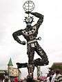 La Nouvelle Liberté, by Joseph-Francis Sumégné
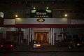 Casino Kheops, Akwa, Boulevard Amadou Ahidjo
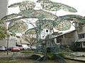 L'Arbre à Palabres, Bonanjo
 Koko Komégné, Njé Mo Yé, Douala, 2007
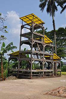 Le jardin sonore de Bonamouti, Bonamouti, Douala, 2010.
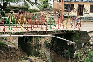 Bessengue Douala. La passerelle (the small bridge) by Alioum Moussa
Education
As in most large cities in Cameroon there are several nursery, primary, secondary and high schools in the city. In recent years there has been a surge in the number of private schools. In is interesting to note that there is also a large informal educational sector that caters for a huge part of the population, mostly to individuals with primary school certificate or those with no education at all. This form of education is common in sectors like cloth manufacture, bread making, construction, security, and car repair. Individuals from these informal sectors are by far the most visible in deprived neighborhoods such as Ndokoti, Bepanda, Village, Logbaba.
The city of Douala is home to a number of higher education institutions, including the University of Douala. There are also a number of professional schools, the most prominent being the Douala Maritime institute. Douala has an aviation school called CAE Oxford Aviation Academy Douala. The city of Douala is, however, mostly a commercial city, hence education is not emphasized as in other cities like Bamenda.
Transportation

Douala is linked by rail to Yaoundé, Ngaoundéré, Kumba and Nkongsamba. Douala has a fairly developed road network compared to other cities in Cameroon. However many of the city's roads have decayed due to years of neglect and corruption. Efforts have recently been made to renovate the city's roads, especially in the most deprived neighborhoods. In spite of the numerous domestic and international investments, the roads remain in deplorable state largely due to embezzlement and corruption.
The Douala International Airport is located in the eastern part of the city. There are direct flights to several European cities, including Paris, Brussels, and Istanbul. Regional and continental destinations include Abidjan, Brazzaville, Dakar, Johannesburg, Kinshasa, Lagos, Malabo, and Nairobi. The airport is the busiest in the CEMAC area and is the hub for Cameroon's national carrier, Camairco. The airport is in dire need of renovations due to poor circulation and old infrastructure.
Economy
Economy
Douala has a modest oil resource of Africa but a very good agricultural condition, thus it has one of best economies in Africa. However, it also faces some problems like other underdeveloped countries such as heavy civil service and bad climate (flood, tornado, storm) to business.[21]
Main economic parameters are:
- GDP: $42.2 billion (2006 est.):
- GDP growth rate: 4.1% (2006 est.)
- Exports-partners: Spain 17.3%, Italy 13.8%, France 9.5%, South Korea 8.1%, UK 8.1%, Netherlands 7.9%, Belgium 4.9%, US 4.3% (2005)
- Imports - partners: France 21%, Nigeria 15%, Belgium 6.3%, China 5.6%, US 5.1%, Thailand 4.5%, Germany 4.2% (2005)
Wealth and poverty
Even though Douala is the economic center of Cameroon, a large percentage of its inhabitants live below the poverty line. Recent data shows that about thirty percent of the population lives in poverty (Avameg, Inc). While the aforementioned percentage is doubled for rural regions, poverty is a growing problem for Douala due to its steadily increasing population. Unlike the rural populations of Cameroon that can grow their own foods to lessen their expenses, Douala locals are disadvantaged by living in the port city where there are not many opportunities for monetary gain.[22]
People
- Louis Brody (1892–1951), german actor
- Prince René Douala Manga Bell (1927-2012), chief of Douala[23]
- Francis Bebey (1929–2001), author
- Manu Dibango (1933–), musician, saxophonist and singer, world jazz, ethno-jazz.
- Jean-Pierre Dikongué Pipa (1940–), cineast
- Patrick Baudry (1946–), second French astronaut and first astronaut of an African country
- Ntonè Ntonè Fritz (1954–), politician
- Élise Mballa (1961–), dancer
- Angèle Etoundi Essamba (1962–), photograph
- Petit Pays (1967–), singer, dancer, author
- Blaise Bang (1968–), artist
- Hemley Boum (1973–), writer
- Achillekà Komguem (1973–), artist
- Jean-Alain Boumsong (1979–), footballer
- Pierre Womé (1979–), footballer
- Killamel (1984–), rap dancer
- Véronique Mang (1984–), sport
- Paul-Georges Ntep (1992–), footballer
- Samuel Eto'o (1981–), footballer
- Narcisse Mouelle Kombi(1962– ), writer and politician
- Christian Ngan (1983- ) entrepreneur, business man and financier
- Pascal Siakam(1992- ), basketball player
Twin towns – sister cities
Doula is twinned with the following places:


See also
References
- ↑ "World Gazetteer". Archived from the original on 11 January 2013.
- ↑ "Cameroon Facts on Largest Cities, Populations, Symbols - Worldatlas.com". www.worldatlas.com. Retrieved 2018-09-06.
- ↑ Notes from Richard Mother Jackson published in R.-P. Bouchaud 1948 and 1952.
- 1 2 3 4 5 6 Diwouta-Kotto, Danièle (2010). Suites architecturales: Kinshasa, Douala, Dakar. Épinal: Association VAA, p. 42.
- ↑ Edmond Kamguia Koumchou (2003), Le Journalisme du Carton Rouge. Douala: Editions l'Etincelle d'Afrique.
- ↑ "Cameroon and the German Lake Chad Railway". World Digital Library. Retrieved 16 February 2013.
- 1 2 3 4 "World Weather Information Service - Douala". World Meteorological Organization. Retrieved 13 June 2016.
- 1 2 "Klimatafel von Douala (Duala), Observatorium / Kamerun" (PDF). Baseline climate means (1961-1990) from stations all over the world (in German). Deutscher Wetterdienst. Retrieved 13 June 2016.
- ↑ "Station Douala" (in French). Meteo Climat. Retrieved 13 June 2016.
- ↑ "Douala Climate Normals 1961–1990". National Oceanic and Atmospheric Administration. Retrieved 13 June 2016.
- ↑ Kouega, Jean-Paul (2007). "The Language Situation in Cameroon". Current Issues in Language Planning. 8 (1): 3–94. doi:10.2167/cilp110.0.
- ↑ La langue française dans le monde, Éditions Nathan, 2014, p. 30.
- ↑ "Douala, Cameroon", in Dickson Eyoh, Paul Tiyambe Zeleza (eds), Encyclopedia of Twentieth Century African History, Routledge, 2002, p. 151.
- ↑ Jacques Soulillou (1989), Douala, un siècle en images. Paris: L'Harmattan, p. 9.
- ↑ French national archives, Section Outre-mer and Départment des Estampes; Documentation Français, Photothèque Afrique; Archives des Pères du Saint-Esprit; Archives des Missions des Églises Évangeliques; Agence France Press.
- ↑ Archives of Mission 21.
- ↑ Welwirtschafsvelten; Deutsch Afrika Linien.
- ↑ Staatliche Archivverwaltung.
- ↑ Archive Photo Prunet.
- ↑ Goethe Institut.
- ↑ "Douala: The Economic Capital Of Cameroon (photos) - Travel - Nigeria". www.nairaland.com. Retrieved 2016-11-12.
- ↑ "Cameroon". www.nationsencyclopedia.com. Retrieved 12 November 2016.
- ↑ "Cameroun : qui était Son Altesse Royale le Prince René Douala Manga Bell ?". afrik.com (in French). 4 January 2013. .
Further reading
- (in English) Brooke, James (1987). "Informal Capitalism Grows in Cameroon." The New York Times. November 30.
- (in English) Derrick, Jonathan (1977). "Review of Douala: ville et histoire by René Gouellain." Africa: Journal of the International African Institute. 47:4.
- (in French) Diwouta-Kotto, Danièle (2010). Suites architecturales: Kinshasa, Douala, Dakar. Épinal: Association VAA.
- (in English) Elate, Som Simon (2004). "African Urban History in the Future." In Steven Salm and Toyin Falola (eds), Globalization and Urbanization in Africa. Trenton: Africa World Press.
- (in French) Gouellain, René (1969). Douala, ville et histoire. Paris: Institut d'ethnologie Musée de l'homme.
- (in English) Hance, William (1964). The Geography of Modern Africa. New York: Columbia University Press.
- (in English) Lambi, C. M. and Hombe, L. F. (2002). "Environmental Hazards and Landuse Planning for Sustainable Development: the Douala Unstable Coastal Region." In R. G. Macinnes and Jenny Jakeways (eds), Instability: Planning and Management. London: Thomas Telford.
- (in French) Lauber, Wolfgang (1988). Architectures allemandes au Cameroun 19884-1914. Stuttgart: Karl Kramer Verlag.
- (in English) Levine, Victor (1971). The Cameroon Federal Republic. Ithaca, NY: Cornell University Press.
- (in French) Mainet, Guy (1985). Douala, croissance et servitudes. Paris: L'Harmattan.
- (in English) Njoh, Ambe (2003). Planning in Contemporary Africa. Aldershot: Ashgate.
- (in French) Séraphin, Gilles (2000). "Vivre à Douala. L'imaginaire et l'action dans une ville africaine en crise". Paris: L'Harmattan.
- (in English) Simone, A. M. (2004). For the City Yet to Come: Changing African Life in Four Cities. Durham: Duke University Press.
- (in French) Soulillou, Jacques (1989), Douala, un siècle en images. Paris: L'Harmattan.
- (in English) Schler, Lynn (2008), The Strangers of New Bell: Immigration, Public Space and Community in Colonial Douala 1914–1960 (Pretoria: Unisa).
- (in English) Brooke, James (1987). "Informal Capitalism Grows in Cameroon." The New York Times. November 30.
- (in English) Derrick, Jonathan (1977). "Review of Douala: ville et histoire by René Gouellain." Africa: Journal of the International African Institute. 47:4.
- (in French) Diwouta-Kotto, Danièle (2010). Suites architecturales: Kinshasa, Douala, Dakar. Épinal: Association VAA.
- (in English) Elate, Som Simon (2004). "African Urban History in the Future." In Steven Salm and Toyin Falola (eds), Globalization and Urbanization in Africa. Trenton: Africa World Press.
- (in French) Gouellain, René (1969). Douala, ville et histoire. Paris: Institut d'ethnologie Musée de l'homme.
- (in English) Hance, William (1964). The Geography of Modern Africa. New York: Columbia University Press.
- (in English) Lambi, C. M., and Hombe, Hombe (2002). "Environmental Hazards and Landuse Planning for Sustainable Development: the Douala Unstable Coastal Region." In R. G. Macinnes and Jenny Jakeways (eds), Instability: Planning and Management. London: Thomas Telford.
- (in French) Lauber, Wolfgang (1988). Architectures allemandes au Cameroun 19884-1914. Stuttgart: Karl Kramer Verlag.
- (in English) Levine, Victor (1971). The Cameroon Federal Republic. Ithaca, NY: Cornell University Press.
- (in French) Mainet, Guy (1985). Douala, croissance et servitudes. Paris: L'Harmattan.
- (in English) Njoh, Ambe (2003). Planning in Contemporary Africa. Aldershot: Ashgate.
- (in French) Séraphin, Gilles (2000). "Vivre à Douala. L'imaginaire et l'action dans une ville africaine en crise". Paris: L'Harmattan.
- (in English) Simone, A. M. (2004). For the City Yet to Come: Changing African Life in Four Cities. Durham: Duke University Press.
- (in French) Soulillou, Jacques (1989), Douala, un siècle en images. Paris: L'Harmattan.
External links
| Wikimedia Commons has media related to Douala. |