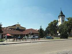
Dolní Bojanovice
| Dolní Bojanovice | |||
|---|---|---|---|
| Municipality | |||
 | |||
| |||
 Dolní Bojanovice | |||
| Coordinates: 48°51′35″N 17°1′40″E / 48.85972°N 17.02778°ECoordinates: 48°51′35″N 17°1′40″E / 48.85972°N 17.02778°E | |||
| Country |
| ||
| Region | South Moravian | ||
| District | Hodonín | ||
| Area | |||
| • Total | 19.92 km2 (7.69 sq mi) | ||
| Elevation | 178 m (584 ft) | ||
| Population (31.12.2010) | |||
| • Total | 2,995 | ||
| • Density | 150/km2 (390/sq mi) | ||
| Postal code | 696 17 | ||
| Website | http://www.dolnibojanovice.cz | ||
Dolní Bojanovice (German: Unter Bojanowitz) is a village and municipality (obec) in Hodonín District in the South Moravian Region of the Czech Republic.
The municipality covers an area of 19.92 square kilometres (7.69 sq mi), and has a population of 2,895 (as at 1 January 2008).
Dolní Bojanovice lies approximately 8 kilometres (5 mi) west of Hodonín, 49 km (30 mi) south-east of Brno, and 233 km (145 mi) south-east of Prague.
References
| Wikimedia Commons has media related to Dolní Bojanovice. |
This article is issued from
Wikipedia.
The text is licensed under Creative Commons - Attribution - Sharealike.
Additional terms may apply for the media files.