Žeraviny
| Žeraviny | |||
|---|---|---|---|
| Municipality | |||
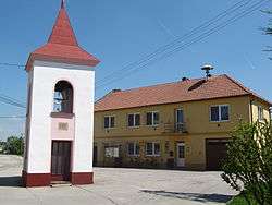 Belfry and municipal office | |||
| |||
 Žeraviny | |||
| Coordinates: 48°54′31″N 17°23′22″E / 48.90861°N 17.38944°ECoordinates: 48°54′31″N 17°23′22″E / 48.90861°N 17.38944°E | |||
| Country |
| ||
| Region | South Moravian | ||
| District | Hodonín | ||
| Area | |||
| • Total | 2.31 km2 (0.89 sq mi) | ||
| Elevation | 187 m (614 ft) | ||
| Population (1.1.2012) | |||
| • Total | 200 | ||
| • Density | 87/km2 (220/sq mi) | ||
| Postal code | 696 63 | ||
Žeraviny is a village and municipality (obec) in Hodonín District in the South Moravian Region of the Czech Republic.
The municipality covers an area of 2.31 square kilometres (0.89 sq mi), and has a population of 194 (as at 1 January 2008).
Žeraviny lies approximately 20 kilometres (12 mi) east of Hodonín, 65 km (40 mi) south-east of Brno, and 252 km (157 mi) south-east of Prague.
References
| Wikimedia Commons has media related to Žeraviny. |
This article is issued from
Wikipedia.
The text is licensed under Creative Commons - Attribution - Sharealike.
Additional terms may apply for the media files.