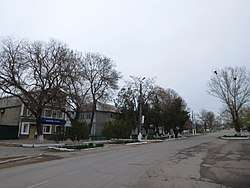
Dobroslav, Ukraine
| Dobroslav Доброслав | |||
|---|---|---|---|
| Urban-type settlement | |||
 | |||
| |||
 Dobroslav  Dobroslav | |||
| Coordinates: 46°49′10″N 30°56′30″E / 46.81944°N 30.94167°ECoordinates: 46°49′10″N 30°56′30″E / 46.81944°N 30.94167°E | |||
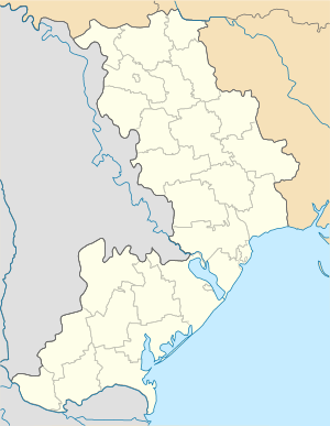
| Country | Ukraine | ||
| Oblast | Odessa Oblast | ||
| Raion | Lyman Raion | ||
| Population (2017) | |||
| • Total | 6,903[1] | ||
| Time zone | UTC+2 (EET) | ||
| • Summer (DST) | UTC+3 (EEST) | ||
Dobroslav (Ukrainian: Доброслав; Russian: Доброслав, formerly Kominternivske) is an urban-type settlement in Odessa Oblast in Ukraine and the administrative center of Lyman Raion. Population: 6,903 (2017 est.)[1]
On 21 May 2016, Verkhovna Rada adopted decision to rename Kominternivske Raion to Lyman Raion and Kominternivske to Dobroslav according to the law prohibiting names of Communist origin.[1]
Dobroslav is located on the banks of the Malyi Adzhalyk River, a tributary of the Hryhorivsky Estuary.
Economy
Transportation
The closest railway station is in Kremydivka, on a railway which connects Odessa with Mykolaiv and Voznesensk.
Dobroslav has access to Highway M14 connecting Odessa and Mykolaiv. Local roads connect it to Berezivka and Ivanivka.
References
- 1 2 3 "Чисельність наявного населення України (Actual population of Ukraine)" (in Ukrainian). State Statistics Service of Ukraine. Retrieved 26 August 2017.
| Raions | |||||
|---|---|---|---|---|---|
| Cities |
| ||||
| |||||
This article is issued from
Wikipedia.
The text is licensed under Creative Commons - Attribution - Sharealike.
Additional terms may apply for the media files.