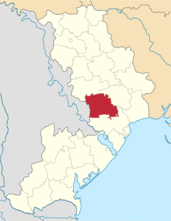
Rozdilna Raion
| Rozdilna Raion Роздільнянський район | |||
|---|---|---|---|
| Raion | |||
| |||
 | |||
| Coordinates: 46°48′24″N 30°10′34″E / 46.80667°N 30.17611°ECoordinates: 46°48′24″N 30°10′34″E / 46.80667°N 30.17611°E | |||
| Country |
| ||
| Region | Odessa Oblast | ||
| Established | 1923 | ||
| Admin. center | Rozdilna | ||
| Subdivisions |
List
| ||
| Government | |||
| • Governor | Baranenko Nataliya Viktorivna | ||
| Area | |||
| • Total | 1,368 km2 (528 sq mi) | ||
| Population | |||
| • Total | 57,894 | ||
| • Density | 42/km2 (110/sq mi) | ||
| Time zone | UTC+2 (EET) | ||
| • Summer (DST) | UTC+3 (EEST) | ||
| Postal index | 67404 | ||
| Area code | 380-4853 | ||
| Website | http://rozdilna-rda.odessa.gov.ua | ||
Rozdilna Raion (Ukrainian: Роздільнянський район) is a raion (district) in Odessa Oblast of Ukraine. Its administrative center is the city of Rozdilna. According to the 2001 Ukrainian census the population was 78% Ukrainian, 14% Russian, 5% Moldovan, 1% Bulgarian, and 1% Belarusian.[1] Population: 57,894 (2018 est.)[2]
The town of Lymanske and the village of Kuchurhan are located at the western edge of the district along the border with Transnistria in Moldova.
References
- ↑ 2001 All Ukrainian population census results for Odessa Region Archived 2009-07-31 at the Wayback Machine.
- ↑ "Чисельність наявного населення України (Actual population of Ukraine)" (PDF) (in Ukrainian). State Statistics Service of Ukraine. Retrieved 11 September 2018.
External links
- (in Ukrainian) Rozdilnianskyi Raion
- (in Ukrainian) Rozdilnianskyi Raion
- (in English) Tourism as catalyst of rural economic development (Rozdilna Raion)
- (in Russian)Раздельная криминальная
| Raions | |||||
|---|---|---|---|---|---|
| Cities |
| ||||
| |||||
This article is issued from
Wikipedia.
The text is licensed under Creative Commons - Attribution - Sharealike.
Additional terms may apply for the media files.