Districts of Seychelles
 |
|---|
| This article is part of a series on the politics and government of Seychelles |
| Constitution |
|
Legislature |
|
Judiciary
|
|
Administrative divisions |
|
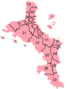

Seychelles is divided into 26 districts. All but one are located on the Inner Islands; the Outer Islands (Zil Elwannyen Sesel) make up the most recent district. Eight of the districts make up Greater Victoria, 14 are located in the rural part of the main island of Mahé, two on Praslin, and one on La Digue (which includes small surrounding islands and some distant islands like Silhouette, North Island, Denis, Bird).
The capital city of Victoria consists of the districts English River, Saint Louis and Mont Fleuri.
Between 1991 and 1993, the originally 23 districts were local government units with elected councils. Since then, they have been governed by government-appointed administrators.[1]
In 1998, two new districts, Roche Caiman and Les Mamelles were created mostly from reclaimed land and from parts of Plaisance. In 2012, another new land reclamation took place, and Eve Island and Rev Island were created near the capital Victoria and Bay St. Anne in Praslin, making the area 459 km2. Also, the Outer Islands were given a status of a district by the ministry of tourism.
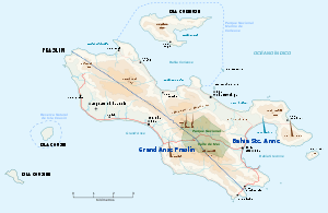
Table of districts
| Nr [lower-alpha 1] | District | Capital | Area | Population | Region | |
|---|---|---|---|---|---|---|
| km² | mi² | |||||
| ** | Mahe Islands | Mahe Islands | 163.2 | 63.0 | 78333 | |
| 01 | Anse aux Pins | Anse Aux Pins | 2.2 | 0.85 | 3673 | East Mahé |
| 02 | Anse Boileau | Anse Boileau | 12.0 | 4.6 | 4183 | West Mahé |
| 03 | Anse Etoile | Anse Etoile | 5.8 | 2.2 | 5018 | North Mahé |
| 04 | Au Cap | La Plaine St. André? | 8.7 | 3.4 | 3743 | East Mahé |
| 05 | Anse Royale | Anse Royale | 6.6 | 2.5 | 3818 | South Mahé |
| 06 | Baie Lazare | Baie Lazare | 12.1 | 4.7 | 3227 | South Mahé |
| 08 | Beau Vallon | Beau Vallon | 4.3 | 1.7 | 4142 | North Mahé |
| 09 | Bel Air | Bel Air | 4.7 | 1.8 | 3015 | Greater Victoria |
| 10 | Bel Ombre | Bel Ombre | 9.2 | 3.6 | 4163 | West Mahé |
| 11 | Cascade | capital | 10.4 | 4.0 | 4088 | East Mahé |
| 12 | Glacis | capital | 7.0 | 2.7 | 4157 | North Mahé |
| 13 | Grand'Anse | Grand'Anse | 15.4 | 5.9 | 2842 | West Mahé |
| 16 | English River | English River | 1.7 | 0.66 | 4252 | Greater Victoria |
| 17 | Mont Buxton | Mont Buxton | 1.2 | 0.46 | 3173 | Greater Victoria |
| 18 | Mont Fleuri | Mont Fleuri | 6.1 | 2.4 | 3966 | Greater Victoria |
| 19 | Plaisance | Plaisance | 3.4 | 1.3 | 3690 | Greater Victoria |
| 20 | Pointe La Rue | Pointe La Rue | 3.9 | 1.5 | 3245 | East Mahé |
| 21 | Port Glaud | Port Glaud | 28.7 | 11.1 | 2378 | West Mahé |
| 22 | Saint Louis | Saint Louis | 1.1 | 0.42 | 3436 | Greater Victoria |
| 23 | Takamaka | Takamaka | 14.4 | 5.6 | 2580 | South Mahé |
| 24 | Les Mamelles | Les Mamelles | 1.8 | 0.69 | 2537 | Greater Victoria |
| 25 | Roche Caïman | Roche Caïman | 1.2 | 0.46 | 2893 | Greater Victoria |
| ** | Praslin Islands | Praslin Islands | 42.2 | 16.3 | 7682 | |
| 07 | Baie Sainte Anne | Anse Volbert | 25.1 | 9.7 | 3626 | Inner Islands |
| 14 | Grand'Anse Praslin | Grand Anse | 14.4 | 5.6 | 4056 | Inner Islands |
| ** | La Digue Islands | La Digue Islands | 41.8 | 16.1 | 3506 | |
| 15 | La Digue and Inner Islands | La Passe | 41.8 | 16.1 | 3506 | Inner Islands |
| ** | Outer Islands | Victoria, Seychelles | 211.8 | 81.8 | 503 | |
| 26 | Outer Islands | (Coëtivy) | 211.8 | 81.8 | 503 | Outer Islands |
| Seychelles | Victoria | 459.0 | 177.2 | 90024 | ||
See also
References
- ↑ "Archived copy" (PDF). Archived from the original (PDF) on 2009-11-04. Retrieved 2009-12-14.
Notes
External links
| Wikimedia Commons has media related to Districts of Seychelles. |
- District Map
- Current District Population Statistics
- District Statistics, with area figures
- Regions of Mahé
- Coats of Arms of Seychelles Districts
| Greater Victoria/ Central Mahé | ||
|---|---|---|
| North Mahé | ||
| East Mahé |
| |
| South Mahé | ||
| West Mahé | ||
| Inner Islands | ||