Dimmsville Covered Bridge
|
Dimmsville Covered Bridge | |
 Dimmsville Covered Bridge | |
  | |
| Location | West of Dimmsville, Greenwood Township, Pennsylvania |
|---|---|
| Coordinates | 40°36′23″N 77°8′20″W / 40.60639°N 77.13889°WCoordinates: 40°36′23″N 77°8′20″W / 40.60639°N 77.13889°W |
| Area | 0.1 acres (0.040 ha) |
| Architectural style | Burr truss |
| MPS | Covered Bridges of Juniata and Snyder Counties TR |
| NRHP reference # | [1] |
| Added to NRHP | August 10, 1979 |
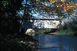
The Dimmsville Covered Bridge was a historic covered bridge located near Dimmsville, Greenwood Township, Juniata County, Pennsylvania. It was a Burr Truss bridge. It measures 100-foot-long (30 m) and had vertical siding, windows at eave level, and a gable roof. It crossed Cocolamus Creek.[2]
It was listed on the National Register of Historic Places in 1979.[1]
The bridge collapsed on April 11, 2017 after years of neglect.[3]
References
- 1 2 National Park Service (2009-03-13). "National Register Information System". National Register of Historic Places. National Park Service.
- ↑ "National Historic Landmarks & National Register of Historic Places in Pennsylvania" (Searchable database). CRGIS: Cultural Resources Geographic Information System. Note: This includes Susan M. Zacher and Tobi Casner (n.d.). "National Register of Historic Places Inventory Nomination Form: Dimmsville Covered Bridge" (PDF). Retrieved 2012-12-29.
- ↑ Schalk, Kiernan (April 17, 2017). "Local covered bridge crumbles". Lewistown Sentinel. Retrieved May 1, 2017.
| Topics |   | |
|---|---|---|
| Lists by county |
| |
| Lists by city | ||
| Other lists | ||
| ||
This article is issued from
Wikipedia.
The text is licensed under Creative Commons - Attribution - Sharealike.
Additional terms may apply for the media files.