Dharmasthali
| Dharmasthali धर्मस्थली | |
|---|---|
| Village of Tarakeshwar Municipality | |
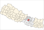
 Dharmasthali Location in Nepal | |
| Coordinates: 27°46′N 85°18′E / 27.76°N 85.30°ECoordinates: 27°46′N 85°18′E / 27.76°N 85.30°E | |
| Country |
|
| Province | No. 3 |
| District | Kathmandu District |
| Population (2011) | |
| • Total | 6,530 |
| Time zone | UTC+5:45 (Nepal Time) |
Dharmasthali is a village and former Village Development Committee that is now part of Tarakeshwar Municipality in Kathmandu District in Province No. 3 of central Nepal. At the time of the 2011 Nepal census it had a population of 6,530 and had 1,421 households in it.[1]
Dharmasthali is popular for its Mahankal temple on the top of a hillock and is only four kilometers from Balaju Ring Road.
Dharmasthali Village Development Committee Consists of 9 wards.Dharmasthali consists of the natives timilsina and newars . The main communities are chettri, brahmin and newar. There are about 500 houses of timilsina family and 600 of newars.
References
- ↑ "Archived copy" (PDF). Archived from the original (PDF) on 2013-07-31. Retrieved 2012-11-01.
This article is issued from
Wikipedia.
The text is licensed under Creative Commons - Attribution - Sharealike.
Additional terms may apply for the media files.