Devil's Courthouse
| Devil's Courthouse | |
|---|---|
 | |
| Highest point | |
| Elevation | 5,720 ft (1,740 m) |
| Coordinates | 35°18′9″N 82°53′44″W / 35.30250°N 82.89556°W |
| Geography | |
| Location | Transylvania County, North Carolina, U.S. |
| Parent range | Appalachian Mountains |
| Topo map | USGS Sam Knob |
| Climbing | |
| Easiest route | Hike |
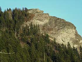
Devil's Courthouse is a mountain in the Appalachian Mountains of western North Carolina in the United States of America.[1] The mountain is located at the Western edge of the Pisgah National Forest about 10 miles (16 kilometers) northwest of Brevard and 28 miles (45 kilometers) southwest of Asheville. Located at milepost 422.4 of the Blue Ridge Parkway, the Devil's Courthouse has a moderate/strenuous trail climbing a half mile to its peak where panoramic views can be seen.

Myth of Judaculla
Cherokee lore had been reported to state that Jutaculla (alternative English spelling is Judaculla; Cherokee name is Tsul'kălû'), a slant eyed giant, dwells in the cave in Devil's Courthouse.[3] However James Mooney, the Cherokee anthropologist, 100 years earlier located Jutaculla to Tanasee Bald[4] where Haywood, Jackson, and Transylvania counties meet. Tanasee Bald is 1.5 miles southwest.[5]
References
- ↑ U.S. Geological Survey Geographic Names Information System: Devil's Courthouse Tunnel
- ↑ "Review of Devil's Courthouse Trail". Retrieved 6 August 2009.
- ↑ Setzer, Lynn (October 31, 1999). "Once upon a time ..." The Raleigh News & Observer. Full text
- ↑ Ellison, George; Mooney, James E. (1992). James Mooney's history, myths, and sacred formulas of the Cherokees: containing the full texts of Myths of the Cherokee (1900) and The sacred formulas of the Cherokees (1891) as published by the Bureau of American Ethnology: with a new biographical introduction, James Mooney and the eastern Cherokees. Asheville, NC: Bright Mountain Books (Historical Images). ISBN 0-914875-19-1. p 479
- ↑ U.S. Geological Survey Geographic Names Information System: Tanasee Bald
External links

Coordinates: 35°18′09″N 82°53′44″W / 35.3025°N 82.895556°W