Derrykeighan
Derrykeighan
| |
|---|---|
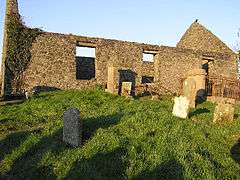 The Old Church, Derrykeighan, in 2006 | |
| County | |
| Country | Northern Ireland |
| Sovereign state | United Kingdom |
| Postcode district | BT53 |
| Dialling code | 028 |
| EU Parliament | Northern Ireland |
| UK Parliament | |
| NI Assembly | |
Derrykeighan (from Irish: Doire Chaocháin, meaning "Caochán’s oak-wood")[1] is a hamlet, civil parish and townland (of 161 acres) in County Antrim, Northern Ireland, 4 miles (7.5km) north of Ballymoney. It is situated in the historic barony of Dunluce Lower.[2]
History
The site of the medieval parish church, and also of an early church, is marked by the ruins of a later church in Derrykeighan.[1]
Civil parish of Derrykeighan
The civil parish covers includes the village of Dervock.[2]
Townlands
The civil parish contains the following townlands:[2]
- Aghancrossy
- Ballydivity
- Ballyhibistock Lower
- Ballyhibistock Upper
- Ballynafeigh
- Ballynarry Upper
- Ballyratahan
- Ballyratahan
- Beerhill
- Bellisle
- Carnaff
- Carncoggy
- Carncullagh Lower
- Carncullagh Middle
- Carncullagh Upper
- Carnfeogue
- Carracloghy
- Chathamhall
- Coole
- Deepstown
- Derrykeighan
- Dervock
- Drumcrottagh
- Glebe
- Gracehill
- Islandahoe
- Knockanboy
- Knockavallan
- Lisconnan
- Lisnabraugh
- Livery Lower
- Livery Upper
- Mostragee
- Mullaghduff
- Stroan Lower
- Stroan Upper
- Tullybane
See also
References
- 1 2 "Derrykeighan". Place Names NI. Retrieved 9 May 2015.
- 1 2 3 "Derrykeighan". IreAtlas Townlands Database. Retrieved 9 May 2015.
| Wikimedia Commons has media related to Derrykeighan. |

This article is issued from
Wikipedia.
The text is licensed under Creative Commons - Attribution - Sharealike.
Additional terms may apply for the media files.