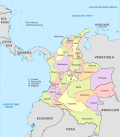
Departments of Colombia
| Capital district and departments of Colombia Distrito Capital y los Departamentos de Colombia (Spanish) | |
|---|---|
  | |
| Category | Unitary state |
| Location | Republic of Colombia |
| Number |
32 Departments 1 Capital District |
| Populations | (Departments only):33,152 (Vaupés) – 5,750,478 (Antioquia) |
| Areas | (Departments only):50 km2 (19.3 sq mi) (San Andrés) – 109,665.0 km2 (42,341.89 sq mi) (Amazonas) |
| Government | Department government, National government |
| Subdivisions | Municipality |
 |
|---|
| This article is part of a series on the politics and government of Colombia |
|
Constitution |
|
Legislature |
|
Executive |
|
Related topics |
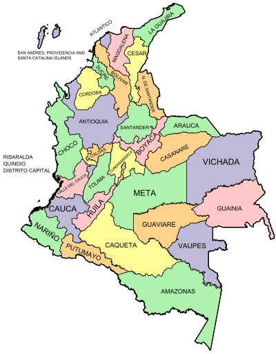
Colombia is a unitary republic made up of thirty-two departments (Spanish: departamentos, sing. departamento) and a Capital District (Distrito Capital).[1] Each department has a Governor (gobernador) and a Department Assembly (Asamblea Departamental), elected by popular vote for a four-year period. The governor cannot be re-elected in consecutive periods. Departments are country subdivisions and are granted a certain degree of autonomy.
Departments are formed by a grouping of municipalities (municipios, sing. municipio). Municipal government is headed by mayor (alcalde) and administered by a Municipal Council (concejo municipal), both of which are elected for four-year periods.
Chart of departments
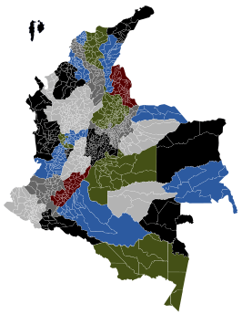
Each one of the departments of Colombia in the map below links to a corresponding article. Current governors serving four-year terms from 2015 to 2019 are also shown, along with their respective political party or coalition.
| ID | Department | Governor | Party | Capital | Area (km²) | Population | Established |
|---|---|---|---|---|---|---|---|
| 00 | Capital District | Enrique Peñalosa | CR | Bogotá | 1,587 | 8,254,722 | 1538 |
| 01 | Amazonas | Manuel Antonio Carebilla Cuéllar | CR | Leticia | 109,665 | 80,360 | 1991 |
| 02 | Antioquia | Luis Pérez | Liberal | Medellín | 63,612 | 5,750,478 | 1826 |
| 03 | Arauca | Ricardo Alvarado Bestene | La U | Arauca | 23,818 | 282,302 | 1991 |
| 04 | Atlántico | Eduardo I. Verano de la Rosa | Liberal | Barranquilla | 3,388 | 2,365,663 | 1910 |
| 05 | Bolívar | Dumek José Turbay Paz | Liberal | Cartagena | 25,978 | 2,229,967 | 1857 |
| 06 | Boyacá | Carlos Andrés Amaya Rodríguez | Green | Tunja | 23,189 | 1,411,239 | 1539 |
| 07 | Caldas | Guido Echeverri Piedrahíta | La U | Manizales | 7,888 | 1,170,187 | 1905 |
| 08 | Caquetá | Álvaro Pacheco Álvarez | Liberal | Florencia | 88,965 | 463,333 | 1982 |
| 09 | Casanare | Josue Alirio Barrera Rodríguez | CD | Yopal | 44,640 | 325,713 | 1991 |
| 10 | Cauca | Óscar Rodrigo Campo Hurtado | Liberal | Popayán | 29,308 | 1,363,054 | 1857 |
| 11 | Cesar | Francisco Fernando Ovalle Angarita | La U | Valledupar | 22,905 | 1,050,303 | 1967 |
| 12 | Chocó | Jhoany Carlos Alberto Palacios Mosquera | Liberal | Quibdó | 46,530 | 413,173 | 1947 |
| 13 | Córdoba | Edwin José Besaile Fayad | La U | Montería | 25,020 | 1,392,905 | 1952 |
| 14 | Cundinamarca | Jorge Emilio Rey Ángel | CR | Bogotá | 24,210 | 2,680,041 | 1857 |
| 15 | Guainía | Javier Eliecer Zapata Parrado | Liberal | Inirida | 72,238 | 43,314 | 1963 |
| 16 | Guaviare | Nebio De Jesús Echeverry Cadavid | AICO | San José del Guaviare | 53,460 | 133,236 | 1991 |
| 17 | Huila | Carlos Julio González Villa | CR | Neiva | 19,890 | 994,218 | 1905 |
| 18 | La Guajira | Oneida Rayeth Pinto Pérez | CR | Riohacha | 20,848 | 524,619 | 1965 |
| 19 | Magdalena | Rosa Cotes De Zuñiga | CR | Santa Marta | 23,188 | 1,403,318 | 1824 |
| 20 | Meta | Marcela Amaya | Liberal | Villavicencio | 85,635 | 771,089 | 1960 |
| 21 | Nariño | Camilo Romero | Green | Pasto | 33,268 | 1,775,139 | 1904 |
| 22 | Norte de Santander | William Villamizar Laguado | La U | Cúcuta | 21,658 | 1,493,932 | 1910 |
| 23 | Putumayo | Sorrel Parisa Aroca Rodríguez | Green | Mocoa | 24,885 | 378,483 | 1991 |
| 24 | Quindío | Carlos Eduardo Osorio Buritica | N/A | Armenia | 1,845 | 613,375 | 1966 |
| 25 | Risaralda | Sigifredo Salazar Osorio | Conservative | Pereira | 4,140 | 1,024,362 | 1966 |
| 26 | San Andrés y Providencia | Ronald Housni Jaller | Liberal | San Andrés | 52 | 83,491 | 1991 |
| 27 | Santander | Didier Alberto Tavera Amado | Liberal | Bucaramanga | 30,537 | 2,085,084 | 1857 |
| 28 | Sucre | Edgar Enrique Martínez Romero | CR | Sincelejo | 10,917 | 868,648 | 1966 |
| 29 | Tolima | Óscar Barreto Quiroga | Conservative | Ibagué | 23,562 | 1,312,972 | 1886 |
| 30 | Valle del Cauca | Dilian Francisca Toro Torres | La U | Cali | 22,140 | 4,524,678 | 1910 |
| 31 | Vaupés | Jesús María Vásquez Caicedo | CR | Mitú | 54,135 | 33,152 | 1991 |
| 32 | Vichada | Luis Carlos Álvarez Morales | La U | Puerto Carreño | 100,242 | 97,276 | 1991 |
- Estimate for Cundinamarca includes the country's capital, Bogotá.
Territorios indígenas
The indigenous territories are at the third level of administrative division in Colombia, as are the municipalities. Indigenous territories are created by agreement between the government and indigenous communities. In cases where indigenous territories covering more than one department or municipality, local governments jointly administer them with the indigenous councils, as set out in Articles 329 and 330 of the Colombian Constitution of 1991. Also indigenous territories may achieve local autonomy if they meet the requirements of the law.
Article 329 of the 1991 constitution recognizes the collective indigenous ownership of indigenous territories and repeats that are inalienable. Law 160 of 1994 created the National System of Agrarian Reform and Rural Development Campesino, and replaced Law 135 of 1961 on Agrarian Social Reform; it establishes and sets out the functions of INCORA, one of the most important being to declare which territories will acquire the status of indigenous protection and what extension of existing ones will be allowed. Decree 2164 of 1995 interprets Law 160 of 1994, providing, among other things, a legal definition of indigenous territories.[2]
Indigenous territories in Colombia are mostly in the departments of Amazonas, Cauca, La Guajira, Guaviare and Vaupés.[1]
History
República de la Gran Colombia
When it was first established in 1819, República de la Gran Colombia had three departments. Venezuela, Cundinamarca (now Colombia) and Quito (now Ecuador).[3] In 1824 the Distrito del Centro (which became Colombia) was divided into five departments, and further divided into seventeen provinces. One department, Istmo Department, consisting of two provinces later became Panama.[4]
República de la Nueva Granada
With the dissolution of Gran Colombia in 1826 by the Revolution of the Morrocoyes (La Cosiata), New Granada kept its 17 provinces. In 1832 the provinces of Vélez and Barbacoas were created, and in 1835 those of Buenaventura and Pasto were added. In 1843 those of Cauca, Mompós and Túquerres were created. At this time the cantons (cantones) and parish districts were created, which provided the basis for the present-day municipalities.[4][5]
By 1853 the number of provinces had increased to thirty-six, namely:Antioquia, Azuero, Barbacoas, Bogotá, Buenaventura, Cartagena, Casanare, Cauca, Chiriquí, Chocó, Córdova, Cundinamarca, García Rovira, Mariquita, Medellín, Mompós, Neiva, Ocaña, Pamplona, Panamá, Pasto, Popayán, Riohacha, Sabanilla, Santa Marta, Santander, Socorro, Soto, Tequendama, Tunja, Tundama, Túquerres, Valle de Upar, Veraguas, Vélez and Zipaquirá.[5] However, the new constitution of 1853 introduced federalism, which lead to the consolidation of provinces into states. By 1858 this process was complete, with a resulting eight federal states: Panamá was formed in 1855, Antioquia in 1856, Santander in May 1857, and Bolívar, Boyacá, Cauca, Cundinamarca and Magdalena were formed in June 1858. 1861 saw the creation of the final federal state of Tolima.[6]
República de Colombia
The Colombian Constitution of 1886 converted the states of Colombia into departments, with the state presidents renamed as governors. The states formed the following original departments:
Maps gallery
 Departments of Colombia with municipalities
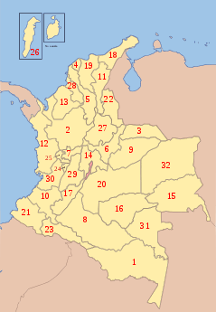 Map with numbered departments
.svg.png) Departments of Colombia with names
Departments of Colombia with names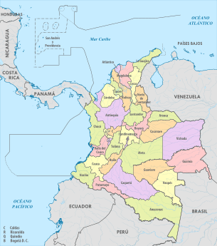 Political map of Colombia
 Topography of Colombia, highly variable per department
See also
References
- 1 2 "Division Política de Colombia" (in Spanish). Portal ColombiaYA.com. Archived from the original on 10 March 2009.
- ↑ Decree 2164 of 1995 provides "Reserva Indígena. Es un globo de terreno baldío ocupado por una o varias comunidades indígenas que fué delimitado y legalmente asignado por el INCORA a aquellas para que ejerzan en él los derechos de uso y usufructo con exclusión de terceros. Las reservas indígenas constituyen tierras comunales de grupos étnicos, para los fines previstos en el artículo 63 de la Constitución Política y la ley 21 de 1991. […] Territorios Indígenas. Son las áreas poseidas en forma regular y permanente por una comunidad, parcialidad o grupo indígena y aquellas que, aunque no se encuentren poseidas en esa forma, constituyen el ámbito tradicional de sus actividades sociales, económicas y culturales. " Art. 21: "Los resguardos son una institución legal y sociopolítica de carácter especial, conformada por una o más comunidades indígenas, que con un título de propiedad colectiva que goza de las garantías de la propiedad privada, poseen su territorio y se rigen para el manejo de éste y su vida interna por una organización autónoma amparada por el fuero indígena y su sistema normativo propio."
- ↑ Guhl Nannetti, Ernesto (1991). "Capítulo XII: División Política de la Gran Colombia". Las fronteras políticas y los límites naturales: escritos geograficos [Political Boundaries and Their Natural Limits: Geographic writings] (in Spanish). Bogotá: Fondo FEN. ISBN 978-958-9129-22-7.
- 1 2 Aguilera Peña, Mario (January 2002). "División política administrativa de Colombia". Credential Historia (in Spanish). Bogotá: Banco de la República. Archived from the original on 16 February 2011.
- 1 2 Oficina Nacional de Estadística (Office of National Statistics) (1876). "Estadística de Colombia" [Colombian Statistics] (PDF) (in Spanish). Bogotá: Oficina Nacional de Estadística. Retrieved 23 November 2016.
- ↑ Domínguez, Camilo; Chaparro, Jeffer; Gómez, Carla (2006). "Construcción y deconstrucción territorial del Caribe Colombiano durante el siglo XIX". Scripta Nova (Revista Electrónica de Geografía y Ciencias Sociales). 10 (218 (75)).
External links
- (in French) List of Colombian departments governors
- "Departments of Colombia". Statoids.
| |||||||