Delaware Route 299
| ||||
|---|---|---|---|---|
 | ||||
| Route information | ||||
| Maintained by DelDOT | ||||
| Length | 9.77 mi[1] (15.72 km) | |||
| Existed | 1957[2][3] – present | |||
| Tourist routes |
| |||
| Major junctions | ||||
| West end |
| |||
| East end |
| |||
| Location | ||||
| Counties | New Castle | |||
| Highway system | ||||
| ||||

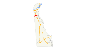
Delaware Route 299 (DE 299) is a 9.77-mile-long (15.72 km) state highway in New Castle County, Delaware. It travels from Maryland Route 282 (MD 282) at the Maryland state line east of Warwick, Maryland to DE 9 in Mathews Corners, traveling through Middletown and Odessa. It is concurrent with U.S. Route 301 (US 301) from just east of the Maryland state line to the west end of Middletown. It is also concurrent with DE 15 along the eastern part of the US 301 concurrency. The highway travels through a mix of suburban development.
DE 299 was originally designated as DE 4 in 1938, traveling as far east as US 13 in Odessa. By 1957, DE 4 became DE 299 to match MD 299 (now MD 282) and was extended east to DE 9 in 1959. Over the years, several different highways had followed the DE 299 alignment including DE 71 west of Middletown between 1959 and 1987 and US 301N between Middletown and Odessa from 1959 to 1971. In 2008, a widening of DE 299 in the western part of Middletown began; it was completed in November 2010.
Route description
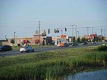
DE 299 heads east from the Maryland border on two-lane undivided Warwick Road, passing through farmland.[4][5] At the state line, the road continues west into Maryland as MD 282.[5] Shortly after the state line, the route curves north, with US 301 parallel to the east. The road turns southeast and comes to an intersection with US 301 and DE 15. At this point, DE 15 and DE 299 become concurrent with US 301 and head northeast on Middletown Warwick Road, a four-lane divided highway. From here, the roadway enters the commercial western part of the town of Middletown. At the point DE 15 makes a left onto Bunker Hill Road, US 301 continues straight and DE 299 makes a right onto Main Street, narrowing to a two-lane undivided road and heading east across the Delmarva Central Railroad's Delmarva Subdivision rail line into the downtown area of Middletown. In the center of town, DE 299 intersects DE 71 (Broad Street).[4][5]
After running through the downtown area, the route heads east through suburban commercial development in the eastern part of Middletown, passing to the north of Middletown High School, and becomes Middletown Odessa Road. The roadway heads south of the Christiana Care Middletown Free-standing Emergency Department before it becomes a divided highway, passing south of a park and ride lot and intersecting the DE 1 toll road at a diamond interchange. Following this interchange, DE 299 becomes undivided again and heads east through a mix of farms and homes into the town of Odessa, where it is called Main Street. In Odessa, the route is lined with homes and intersects US 13, which is split onto 5th Street northbound and 6th Street southbound. Following this intersection, the road runs through the Odessa Historic District.[4][5] Past Odessa, DE 299 crosses the Appoquinimink River and heads to the southeast on Old State Road into housing developments.[5] The route curves south before makes a turn southeast onto Taylors Bridge Road and ends a short distance later at DE 9 in Mathews Corners.[4][5]
Portions of DE 299 are designated as part of the Delaware Byways system. The section between Silver Lake Road in Middletown and DE 9 is part of the Harriet Tubman Underground Railroad Byway while the section between US 13 in Odessa and DE 9 is a spur of the Delaware's Bayshore Byway.[6][7] DE 299 has an annual average daily traffic count ranging from a high of 18,470 vehicles along Main Street in Middletown to a low of 727 vehicles at the eastern terminus at DE 9.[1] The portion of DE 299 concurrent with US 301 is part of the National Highway System.[8]
History
| |
|---|---|
| Location | Near Warwick, Maryland–Odessa |
| Length | 8.08 mi[1] (13.00 km) |
| Existed | 1938[9]–1957[2][3] |
By 1920, what is now DE 299 existed as an unimproved county road.[10] This county road was paved by 1924.[11] The present-day alignment of DE 299 became a state highway by 1935.[12][13] The current DE 299 was originally designated as DE 4 in 1938, running between the Maryland border and US 13 in Odessa.[9] By 1957, DE 4 was renumbered to DE 299 to match MD 299 (now MD 282) across the border and DE 71 was designated concurrent with most of the route west of Middletown.[2][3] US 301 was designated along the DE 71/DE 299 concurrency in 1959 while US 301N was designated between DE 71 and US 13. Also at this time, DE 299 was extended east to DE 9.[14] The US 301N designation was removed between Middletown and Odessa in 1971.[15][16] DE 71 was rerouted off US 301/DE 299 by 1987.[17] By 1994, DE 15 was designated to follow a portion of US 301/DE 299 west of Middletown.[18] In July 2008, a widening project began on US 301/DE 299 between United Drive and the east end of the concurrency.[19] This widening to four lanes was completed in November 2010.[20] On July 15, 2017, DE 299 was realigned near the Maryland border as a result of construction of the US 301 freeway.[21]
Major intersections
The entire route is in New Castle County.
| Location | mi[1] | km | Destinations | Notes | |
|---|---|---|---|---|---|
| | 0.00 | 0.00 | Maryland state line; western terminus | ||
| Middletown | 3.13 | 5.04 | West end of US 301/DE 15 overlap | ||
| 4.35 | 7.00 | East end of US 301/DE 15 overlap | |||
| 4.68 | 7.53 | ||||
| Odessa | DE 1 exit 136 | ||||
| 7.99 | 12.86 | ||||
| 8.08 | 13.00 | ||||
| Mathews Corners | 9.77 | 15.72 | Eastern terminus | ||
1.000 mi = 1.609 km; 1.000 km = 0.621 mi
| |||||
See also


References
- 1 2 3 4 Staff (2016). "Traffic Count and Mileage Report: Interstate, Delaware, and US Routes" (PDF). Delaware Department of Transportation. Retrieved December 29, 2017.
- 1 2 3 Delaware State Highway Department (1954). Official Highway Map of Delaware (PDF) (Map) (1954–1955 ed.). Dover: Delaware State Highway Department. Retrieved November 24, 2015.
- 1 2 3 Delaware State Highway Department (1957). Official Highway Map of Delaware (PDF) (Map) (1957–1958 ed.). Dover: Delaware State Highway Department. Retrieved November 24, 2015.
- 1 2 3 4 Delaware Department of Transportation (2017). Official Travel & Transportation Map (Map). Dover: Delaware Department of Transportation.
- 1 2 3 4 5 6 Google (2010-04-29). "overview of Delaware Route 299" (Map). Google Maps. Google. Retrieved 2010-04-29.
- ↑ "Harriet Tubman Underground Railroad Byway". Delaware Department of Transportation. Retrieved December 30, 2017.
- ↑ "Delaware's Bayshore Byway". Delaware Department of Transportation. Retrieved December 30, 2017.
- ↑ National Highway System: Delaware (PDF) (Map). Federal Highway Administration. 2010. Retrieved February 10, 2012.
- 1 2 Delaware State Highway Department; The National Survey Co. (1938). Official Road Map of the State of Delaware (PDF) (Map). Dover: Delaware State Highway Department. Retrieved November 24, 2015.
- ↑ Delaware State Highway Department (1920). Official Road Map (PDF) (Map). Dover: Delaware State Highway Department. Retrieved November 24, 2015.
- ↑ Delaware State Highway Department (1924). Official Road Map (PDF) (Map). Dover: Delaware State Highway Department. Retrieved March 9, 2016.
- ↑ "Delaware State Highway Department Annual Report" (PDF) (1958 ed.). Dover, Delaware: Delaware State Highway Department. 1958: 4–13. Retrieved November 13, 2014.
- ↑ Delaware State Highway Department; The National Survey Co. (1936). Official Road Map of the State of Delaware (PDF) (Map) (1936–1937 ed.). Dover: Delaware State Highway Department. Retrieved March 9, 2016.
- ↑ Delaware State Highway Department (1959). Official Highway Map of Delaware (PDF) (Map) (1959–1960 ed.). Dover: Delaware State Highway Department. Retrieved November 24, 2015.
- ↑ Delaware Department of Highways and Transportation (1971). Delaware Highways Official Map (PDF) (Map). Dover: Delaware Department of Highways and Transportation. Retrieved November 24, 2015.
- ↑ U.S. Route Numbering Subcommittee (December 3, 1971). "U.S. Route Numbering Subcommittee Agenda" (PDF) (Report). Washington, DC: American Association of State Highway Officials. p. 415. Retrieved October 11, 2014 – via Wikimedia Commons.
- ↑ Delaware Department of Transportation (1987). Official State Highway Map (PDF) (Map). Dover: Delaware Department of Transportation. Retrieved November 24, 2015.
- ↑ Delaware Department of Transportation Division of Planning Cartographic Information Section (1994). Delaware Official State Map (PDF) (Map). Dover: Delaware Department of Transportation. Retrieved November 24, 2015.
- ↑ "Existing Route 301 Widening to Begin" (Press release). Delaware Department of Transportation. July 20, 2008. Retrieved 2010-04-29.
- ↑ "Traffic Alert – Sections of Route 301 Closed for Construction" (Press release). Delaware Department of Transportation. September 30, 2009. Retrieved 2010-04-29.
- ↑ "Traffic Alert - Middletown/Warwick Road Reopened July 15, As Part of the U.S. 301 Mainline Project" (Press release). Delaware Department of Transportation. July 10, 2017. Retrieved November 28, 2017.
Route map:
| Wikimedia Commons has media related to Delaware Route 299. |