De Smet Range
| De Smet Range | |
|---|---|
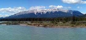 De Smet Range and Athabasca River | |
| Highest point | |
| Peak | Roche de Smet |
| Elevation | 2,539 m (8,330 ft) |
| Coordinates | 53°08′05″N 118°07′00″W / 53.13472°N 118.11667°W |
| Geography | |
| Country | Canada |
| Province | Alberta |
| Range coordinates | 53°10′N 118°13′W / 53.167°N 118.217°WCoordinates: 53°10′N 118°13′W / 53.167°N 118.217°W |
| Parent range | Canadian Rockies |
The De Smet Range is a mountain range of the Canadian Rockies located northwest of Highway 16 and Jasper Lake in Jasper National Park, Canada. The range is named after its highest point Roche de Smet, which in turn was named by Iroquois working in the fur trade industry. The Iroquois named the peak after Pierre-Jean De Smet, a Belgian missionary who had worked with the indigenous native peoples in the 1840s in Western Canada and Northwestern United States.[1]
This range includes the following mountains and peaks:[2]
| Mountain/Peak | metres | feet |
|---|---|---|
| Roche de Smet | 2,539 m | 8,330 ft |
| Mount Cumnock | 2,460 m | 8,070 ft |
| Mount Bistre | 2,346 m | 7,697 ft |
| Mount Greenock | 2,065 m | 6,775 ft |
References
- ↑ "De Smet Range". Bivouac Mountain Encyclopedia. Bivouac.com. Retrieved 2009-01-10.
- ↑ "De Smet Range". PeakFinder. Retrieved 2009-01-10.
This article is issued from
Wikipedia.
The text is licensed under Creative Commons - Attribution - Sharealike.
Additional terms may apply for the media files.