Day, Minnesota
| Day, Minnesota | |
|---|---|
| Unincorporated community | |
 Day  Day | |
| Coordinates: 45°42′33″N 93°22′46″W / 45.70917°N 93.37944°WCoordinates: 45°42′33″N 93°22′46″W / 45.70917°N 93.37944°W | |
| Country | United States |
| State | Minnesota |
| County | Isanti |
| Township | Maple Ridge Township |
| Elevation | 1,033 ft (315 m) |
| Time zone | UTC-6 (Central (CST)) |
| • Summer (DST) | UTC-5 (CDT) |
| ZIP code | 55006 |
| Area code(s) | 320 |
| GNIS feature ID | 642660[1] |
Day is an unincorporated community in Maple Ridge Township, Isanti County, Minnesota, United States.
Isanti County Roads 4 and 22 are two of the main routes in the community. Nearby places include Dalbo, Coin, Braham, Lewis Lake, and Cranberry Wildlife Management Area. State Highway 47 (MN 47) is nearby.
References
- Official State of Minnesota Highway Map – 2013/2014 edition
Municipalities and communities of Isanti County, Minnesota, United States | ||
|---|---|---|
| Cities | 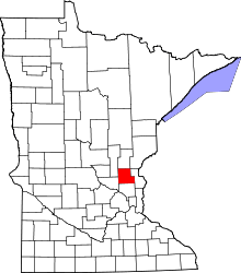 | |
| Townships | ||
| CDP | ||
| Unincorporated communities | ||
| Ghost town | ||
| Footnotes | ‡This populated place also has portions in an adjacent county or counties | |
Day's vibrant socio-economic function began circa 1910 and was concluded by 1970. Once a thriving micro-center of commerce, Day listed a Farmer's Co-op Creamery complete with frozen food lockers for the public's rental, a feed mill (Harry Brightbill), a hardware store (Arthur Wallen), a grocery & dry goods store (John Kranz), an egg produce, a tavern, and a automobile service and repair garage (Ruben Edblad).[1]
- ↑ Darrel Franson, area resident 1944-1980
This article is issued from
Wikipedia.
The text is licensed under Creative Commons - Attribution - Sharealike.
Additional terms may apply for the media files.