Andree, Minnesota
| Andree, Minnesota | |
|---|---|
| Unincorporated community | |
 Andree  Andree | |
| Coordinates: 45°43′42″N 93°13′26″W / 45.72833°N 93.22389°WCoordinates: 45°43′42″N 93°13′26″W / 45.72833°N 93.22389°W | |
| Country | United States |
| State | Minnesota |
| County | Isanti |
| Township | Stanchfield Township |
| Elevation | 958 ft (292 m) |
| Time zone | UTC-6 (Central (CST)) |
| • Summer (DST) | UTC-5 (CDT) |
| ZIP code | 55006 |
| Area code(s) | 320 |
| GNIS feature ID | 654569[1] |
Andree is an unincorporated community in Stanchfield Township, Isanti County, Minnesota, United States.
Isanti County Road 4 and State Highway 65 (MN 65) are two of the main routes in the community.
Nearby places include Braham, Stanchfield, Coin, Brunswick, and Rice Creek Wildlife Management Area.
References
- Rand McNally Road Atlas – 2007 edition – Minnesota entry
Municipalities and communities of Isanti County, Minnesota, United States | ||
|---|---|---|
| Cities | 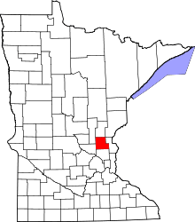 | |
| Townships | ||
| CDP | ||
| Unincorporated communities | ||
| Ghost town | ||
| Footnotes | ‡This populated place also has portions in an adjacent county or counties | |
This article is issued from
Wikipedia.
The text is licensed under Creative Commons - Attribution - Sharealike.
Additional terms may apply for the media files.