Crown, Minnesota
| Crown, Minnesota | |
|---|---|
| Unincorporated community | |
 Crown  Crown | |
| Coordinates: 45°26′41″N 93°27′37″W / 45.44472°N 93.46028°WCoordinates: 45°26′41″N 93°27′37″W / 45.44472°N 93.46028°W | |
| Country | United States |
| State | Minnesota |
| County | Isanti |
| Township | Stanford Township |
| Elevation | 961 ft (293 m) |
| Time zone | UTC-6 (Central (CST)) |
| • Summer (DST) | UTC-5 (CDT) |
| Area code(s) | 763 |
| GNIS feature ID | 642513[1] |
Crown is an unincorporated community in Stanford Township, Isanti County, Minnesota, United States. The community is located north of St. Francis.
Isanti County Roads 7 and 8 are two of the main routes in the community. State Highway 47 (MN 47) and U.S. Highway 169 are nearby.
History
Crown was founded in the late 19th century by primarily German immigrants. It had a creamery, three stores with bars, a blacksmith shop, a garage repair shop, and a German Lutheran Church and a Lutheran School.
The Lemke family owned the remaining community store from 1905 to 2005, when it was sold and renamed "Crown Gas and Goodies".
In 2008, a fire destroyed the County Line Bar and Grill, formerly Herlinger's general store, and the Farmers Cooperative Mercantile Company of West Stanford it reopened January 2013 at the same location. Crown largely consists of the store, County Line Bar, and Zion Lutheran Church and School one mile north of Crown.
References
- Rand McNally Road Atlas – 2007 edition – Minnesota entry
- Official State of Minnesota Highway Map – 2013/2014 edition
Municipalities and communities of Isanti County, Minnesota, United States | ||
|---|---|---|
| Cities | 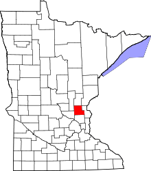 | |
| Townships | ||
| CDP | ||
| Unincorporated communities | ||
| Ghost town | ||
| Footnotes | ‡This populated place also has portions in an adjacent county or counties | |