Carmody, Minnesota
| Carmody, Minnesota | |
|---|---|
| Unincorporated community | |
 Carmody  Carmody | |
| Coordinates: 45°39′06″N 93°28′17″W / 45.65167°N 93.47139°WCoordinates: 45°39′06″N 93°28′17″W / 45.65167°N 93.47139°W | |
| Country | United States |
| State | Minnesota |
| County | Isanti |
| Township | Dalbo Township |
| Elevation | 984 ft (300 m) |
| Time zone | UTC-6 (Central (CST)) |
| • Summer (DST) | UTC-5 (CDT) |
| ZIP code | 55017 and 55371 |
| Area code(s) | 763 |
| GNIS feature ID | 654630[1] |
Carmody is an unincorporated community in Dalbo Township, Isanti County, Minnesota, United States.
Isanti County Roads 13, 15, and 62 are three of the main routes in the community. Nearby places include Dalbo, Wyanett, and Princeton.
References
- Official State of Minnesota Highway Map – 2013/2014 edition
Municipalities and communities of Isanti County, Minnesota, United States | ||
|---|---|---|
| Cities | 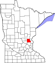 | |
| Townships | ||
| CDP | ||
| Unincorporated communities | ||
| Ghost town | ||
| Footnotes | ‡This populated place also has portions in an adjacent county or counties | |
This article is issued from
Wikipedia.
The text is licensed under Creative Commons - Attribution - Sharealike.
Additional terms may apply for the media files.