State road D.400 (Turkey)
| |
|---|---|
 | |
| Route information | |
|
Part of | |
| Length | 2,057 km (1,278 mi) |
| Major junctions | |
| West end | Datça |
| East end |
|
| Highway system | |
|
Turkish State Highway System (Devlet Yolu) List | |

State road D400 near Şanlıurfa

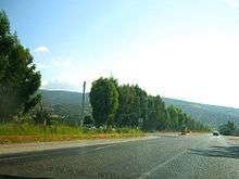
Between Kumluca and Kemer (Antalya Province)

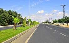
In Antalya as Dumlupınar Bulvarı
Between Yeşilovacık and Silifke (Mersin Province)
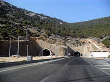
Boğsak Tunnel (Mersin Province)
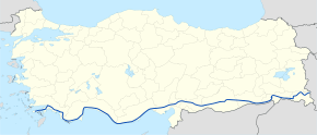
D-400 is an east–west state road in southern Turkey. The 2,057-kilometre (1,278 mi) road starts at Datça in the southwest corner of the Anatolian peninsula. The road ends at the Iranian border at Esendere.
D-400 runs through the cities of Marmaris, Fethiye, Antalya, Alanya, Mersin, Adana, Gaziantep, Şanlıurfa, and Hakkâri and links to Road 16 ![]()
![]()
Itinerary
In the table below the locations between Datça and Esendere are shown.[1]
| Province | City | Distance from previous location |
Distance from Datça |
Distance from Esendere |
|---|---|---|---|---|
| Muğla | Datça | 0 | 0 | 2,057 |
| Bozburun | 51 | 51 | 2,006 | |
| Marmaris | 18 | 69 | 1,988 | |
| Muğla | 27 | 96 | 1,961 | |
| Köyceğiz | 33 | 129 | 1,928 | |
| Ortaca | 18 | 147 | 1,910 | |
| Dalaman | 5 | 152 | 1,905 | |
| Fethiye | 43 | 195 | 1,862 | |
| Eşen | 44 | 239 | 1,818 | |
| Antalya | Kalkan | 36 | 275 | 1,782 |
| Kaş | 26 | 301 | 1,756 | |
| Demre | 47 | 348 | 1,609 | |
| Finike | 28 | 376 | 1,681 | |
| Kumluca | 18 | 394 | 1,663 | |
| Kemer | 52 | 446 | 1,611 | |
| Antalya | 42 | 488 | 1,569 | |
| Serik | 42 | 530 | 1,527 | |
| Manavgat | 36 | 566 | 1,491 | |
| Alanya | 60 | 626 | 1,431 | |
| Gazipaşa | 44 | 670 | 1,387 | |
| Mersin | Kaledran | 39 | 709 | 1,348 |
| Anamur | 45 | 754 | 1,303 | |
| Bozyazı | 14 | 768 | 1,289 | |
| Aydıncık | 39 | 807 | 1,150 | |
| Yeşilovacık | 44 | 851 | 1,206 | |
| Silifke | 42 | 893 | 1,164 | |
| Erdemli | 46 | 939 | 1,118 | |
| Mersin | 38 | 977 | 1,080 | |
| Tarsus | 28 | 1,005 | 1,053 | |
| Adana | ||||
| Adana | 42 | 1,047 | 1,010 | |
| Misis | 21 | 1,068 | 989 | |
| Ceyhan | 24 | 1,092 | 965 | |
| Osmaniye | ||||
| Osmaniye | 51 | 1,143 | 914 | |
| Bahçe | 30 | 1,173 | 884 | |
| Gaziantep | ||||
| Nurdağı | 21 | 1,194 | 853 | |
| Gaziantep | 62 | 1,256 | 801 | |
| Nizip | 45 | 1,301 | 756 | |
| Şanlıurfa | ||||
| Birecik | 16 | 1,317 | 740 | |
| Şanlıurfa | 80 | 1,397 | 660 | |
| Viranşehir | 91 | 1,488 | 569 | |
| Mardin | ||||
| Kızıltepe | 73 | 1,561 | 496 | |
| Nusaybin | 56 | 1,617 | 440 | |
| Şırnak | ||||
| Cizre | 100 | 1,717 | 340 | |
| Şırnak | 46 | 1,763 | 294 | |
| Hakkari | ||||
| Hakkâri | 183 | 1,946 | 111 | |
| Yüksekova | 70 | 2,016 | 41 | |
| Esendere (Iranian border) |
41 | 2,057 | 0 | |
| 1.000 mi = 1.609 km; 1.000 km = 0.621 mi | ||||
Intersections


- 27-26 at Nizip


References
- ↑ Vatan Türkiye Turizm Atlası, Boyut Yayıları ,İstanbul, 2009 ISBN 978-975-23-0634--9, pp 90-97
| East–west highways | |
|---|---|
| North–south highways |
|
Main highways highlighted | |
This article is issued from
Wikipedia.
The text is licensed under Creative Commons - Attribution - Sharealike.
Additional terms may apply for the media files.