Darkesville, West Virginia
|
Darkesville Historic District | |
 | |
  | |
| Location | US 11 at Middle Creek, Darkesville, West Virginia |
|---|---|
| Coordinates | 39°22′27″N 78°1′25″W / 39.37417°N 78.02361°WCoordinates: 39°22′27″N 78°1′25″W / 39.37417°N 78.02361°W |
| Architect | Multiple |
| Architectural style | Greek Revival, Gothic, Federal |
| MPS | Berkeley County MRA |
| NRHP reference # | 80004410[1] |
| Added to NRHP | December 10, 1980 |
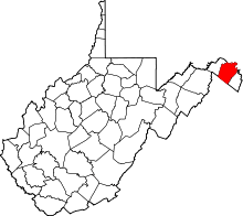
Darkesville is an unincorporated community in Berkeley County, West Virginia, United States. Established in 1791,[2] Darkesville has been nationally recognized as a historic district.[3]:7
A post office and school (now closed) once operated in Darkesville.[4][5]
Geography
Darkesville lies between Inwood and Martinsburg along U.S. Route 11.[6] The community's elevation is 531 feet (162 m), and it is located at about 39°22′25″N 78°1′30″W / 39.37361°N 78.02500°W (39.3738500, -78.0248602).[2]
Middle Creek flows through the center of Darkesville.[6]
Name
Established by an act of the Virginia General Assembly on December 7, 1791 on the property of James Buckells,[7] Darkesville is named for William Darke, a Virginia military officer who had his headquarters in the community.[3]:7 Historically, Darkesville has been known by various names and a wide variety of spellings. An 1895 atlas showed the community as "Buckletown", and later variants included "Buckellstown", "Buckels Town", "Buckelstown", "Buckle Town" and "Bucklestown", all referring to the entrepreneurial James Buckles (1732-1796) who contributed land and laid out the town in 1790.[8] "James Town" and "Locke" have also been applied to the community. Its current name has also been spelled "Darkes" and "Darkville".[2]
Historic district
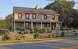
In 1980, the community was listed on the National Register of Historic Places as a historic district.[1] Darkesville was recognized for its historic architecture, which includes approximately twenty-five buildings constructed as log cabins in 1810 or earlier.[3]:2, 12, 13
References
- 1 2 National Park Service (2009-03-13). "National Register Information System". National Register of Historic Places. National Park Service.
- 1 2 3 U.S. Geological Survey Geographic Names Information System: Darkesville, West Virginia
- 1 2 3 Wood, Don C. National Register of Historic Places Inventory/Nomination: Darkesville Historic District. National Park Service, c. 1980.
- ↑ U.S. Geological Survey Geographic Names Information System: Darkesville Post Office
- ↑ U.S. Geological Survey Geographic Names Information System: Darkesville School
- 1 2 DeLorme. West Virginia Atlas & Gazetteer. 4th ed. Yarmouth: DeLorme, 2007, 30. ISBN 0-89933-327-3.
- ↑ "An act to establish several Towns, and for other purposes. Hening's Statutes at Large, Vol. XIII, Chapter LIV". vagenweb.org. Retrieved 2017-03-05.
- ↑ Don C. Wood, Berkeley Journal 34:15, Berkeley County Historical Society, Martinsburg, WV, 1980
| Topics |  | |
|---|---|---|
| Lists by county |
| |
| Other lists | ||
| ||