| [3] |
Name on the Register |
Image |
Date listed[4] |
Location |
City or town |
Description |
|---|
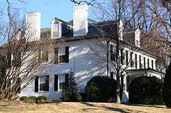
| 1 |
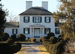
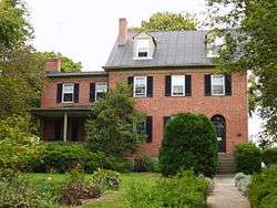
Christian Allemong House |
|
May 2, 2003
(#03000346) |
35 Hardestry Rd.
39°14′14″N 77°58′43″W / 39.237222°N 77.978611°W / 39.237222; -77.978611 (Christian Allemong House) |
Summit Point |
|
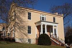
| 2 |
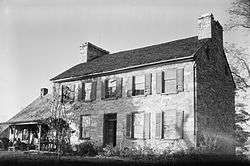
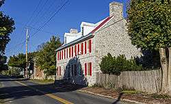
Allstadt House and Ordinary |
|
April 9, 1985
(#85000767) |
Junction of U.S. Route 340 and County Road 27
39°18′59″N 77°45′20″W / 39.31626°N 77.75568°W / 39.31626; -77.75568 (Allstadt House and Ordinary) |
Harpers Ferry |
|
| 3 |
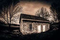
Altona |
|
November 24, 1995
(#95001322) |
WV 51 west of Charles Town
39°17′24″N 77°52′57″W / 39.29°N 77.8825°W / 39.29; -77.8825 (Altona) |
Charles Town |
|
| 4 |
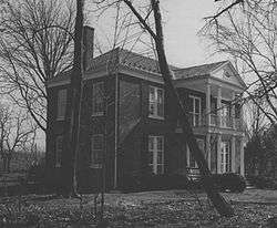
Aspen Hill |
|
March 13, 1980
(#80004024) |
North of Charles Town on WV 9
39°19′18″N 77°51′44″W / 39.321667°N 77.862222°W / 39.321667; -77.862222 (Aspen Hill) |
Charles Town |
|
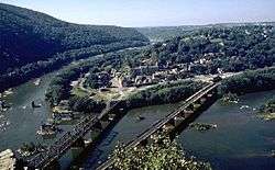
| 5 |
B & O Railroad Potomac River Crossing |
|
February 14, 1978
(#78001484) |
At the confluence of the Shenandoah and Potomac Rivers
39°19′27″N 77°43′43″W / 39.324167°N 77.728611°W / 39.324167; -77.728611 (B & O Railroad Potomac River Crossing) |
Harpers Ferry |
|
| 6 |
Barleywood |
|
May 24, 2007
(#07000241) |
Ambler Rd., approximately 1 mi (1.6 km) north of WV 51
39°18′54″N 77°54′42″W / 39.314883°N 77.911792°W / 39.314883; -77.911792 (Barleywood) |
Charles Town |
|
| 7 |
Beall-Air |
|
August 17, 1973
(#73001914) |
West of Halltown off U.S. Route 340
39°18′55″N 77°48′44″W / 39.315278°N 77.812222°W / 39.315278; -77.812222 (Beall-Air) |
Halltown |
|
| 8 |
Belvedere |
|
January 12, 1984
(#84003588) |
76 Belvedere Farm Dr.
39°17′05″N 77°50′43″W / 39.284722°N 77.845278°W / 39.284722; -77.845278 (Belvedere) |
Charles Town |
|
| 9 |
Beverley |
|
March 20, 1987
(#87000486) |
U.S. Route 340; also 1 Burns Farm Rd.
39°15′03″N 77°53′34″W / 39.250833°N 77.892778°W / 39.250833; -77.892778 (Beverley) |
Charles Town |
Burns Farm represents a boundary increase of April 12, 2010 |
| 10 |
Blakeley |
|
April 15, 1982
(#82004319) |
Huyett Road
39°15′36″N 77°54′22″W / 39.26°N 77.906111°W / 39.26; -77.906111 (Blakeley) |
Charles Town |
|
| 11 |
Boidstones Place |
|
November 22, 1999
(#99001397) |
Shepherd Grade
39°28′11″N 77°48′06″W / 39.469722°N 77.801667°W / 39.469722; -77.801667 (Boidstones Place) |
Shepherdstown |
|
| 12 |
The Bower |
|
April 15, 1982
(#82004321) |
County Road 1/1
39°21′54″N 77°57′27″W / 39.365°N 77.9575°W / 39.365; -77.9575 (The Bower) |
Leetown |
|
| 13 |
Peter Burr House |
|
April 9, 1982
(#82004322) |
Warm Springs Rd.
39°21′34″N 77°51′25″W / 39.359444°N 77.856944°W / 39.359444; -77.856944 (Peter Burr House) |
Shenandoah Junction |
|
| 14 |
Cedar Lawn |
|
December 4, 1974
(#74002004) |
3.5 mi (5.6 km) west of Charles Town off Virginia State Route 51 and south on County Road 51/1
39°17′06″N 77°55′22″W / 39.285°N 77.922778°W / 39.285; -77.922778 (Cedar Lawn) |
Charles Town |
|
| 15 |
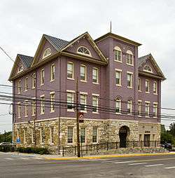
Charles Town Mining, Manufacturing, and Improvement Company Building |
|
August 2, 2001
(#01000779) |
312 S. Mildred St.
39°17′40″N 77°51′38″W / 39.294444°N 77.860556°W / 39.294444; -77.860556 (Charles Town Mining, Manufacturing, and Improvement Company Building) |
Ranson |
|
| 16 |
Claymont Court |
|
July 25, 1973
(#73001908) |
Southwest of Charles Town off U.S. Route 340
39°16′07″N 77°54′21″W / 39.268611°N 77.905833°W / 39.268611; -77.905833 (Claymont Court) |
Charles Town |
|
| 17 |
Cold Spring |
|
August 14, 1973
(#73001917) |
South of Shepherdstown on County Road 17
39°23′48″N 77°49′05″W / 39.396667°N 77.818056°W / 39.396667; -77.818056 (Cold Spring) |
Shepherdstown |
|
| 18 |
Cool Spring Farm |
|
March 27, 2007
(#07000239) |
1735 Lloyd Rd.
39°14′44″N 77°55′55″W / 39.24556°N 77.93194°W / 39.24556; -77.93194 (Cool Spring Farm) |
Charles Town |
|
| 19 |
Downtown Charles Town Historic District |
|
March 21, 1997
(#97000263) |
Roughly Washington, Liberty, and Congress Sts. from the eastern town limits to Water St.
39°17′21″N 77°51′33″W / 39.289167°N 77.859167°W / 39.289167; -77.859167 (Downtown Charles Town Historic District) |
Charles Town |
|
| 20 |
Duffields Depot |
|
August 3, 2007
(#07000780) |
45 Melvin Rd.
39°21′46″N 77°49′32″W / 39.36282°N 77.82568°W / 39.36282; -77.82568 (Duffields Depot) |
Shenandoah Junction |
|
| 21 |
Elmwood |
|
August 17, 1973
(#73001918) |
South of Shepherdstown off County Road 17
39°23′50″N 77°48′50″W / 39.397222°N 77.813889°W / 39.397222; -77.813889 (Elmwood) |
Shepherdstown |
|
| 22 |
Elmwood-on-the-Opequon |
|
March 22, 2006
(#06000165) |
3898 Sulphur Springs Rd.
39°21′13″N 77°57′43″W / 39.353611°N 77.961944°W / 39.353611; -77.961944 (Elmwood-on-the-Opequon) |
Kearneysville |
|
| 23 |
Falling Spring-Morgan's Grove |
|
February 15, 1989
(#88002670) |
WV 480
39°25′15″N 77°48′55″W / 39.420833°N 77.815278°W / 39.420833; -77.815278 (Falling Spring-Morgan's Grove) |
Shepherdstown |
|
| 24 |
Feagans' Mill Complex |
|
January 23, 2017
(#100000572) |
28 Feagans' Mill Ln.
39°14′31″N 77°55′19″W / 39.241893°N 77.921822°W / 39.241893; -77.921822 (Feagans' Mill Complex) |
Charles Town |
|
| 25 |
Fruit Hill |
|
September 26, 1988
(#88001588) |
Shepherd Grade
39°26′53″N 77°49′28″W / 39.448056°N 77.824444°W / 39.448056; -77.824444 (Fruit Hill) |
Shepherdstown |
|
| 26 |
Gap View Farm |
|
January 9, 1997
(#96001574) |
WV 9, between Charles Town and Shenandoah Junction
39°20′32″N 77°50′58″W / 39.342222°N 77.849444°W / 39.342222; -77.849444 (Gap View Farm) |
Charles Town |
|
| 27 |
Gibson-Todd House |
|
September 1, 1983
(#83003238) |
515 S. Samuel St.
39°17′07″N 77°51′21″W / 39.28534°N 77.85592°W / 39.28534; -77.85592 (Gibson-Todd House) |
Charles Town |
|
| 28 |
Glenburnie |
|
November 29, 1988
(#88002668) |
County Road 16/Ridge Rd.
39°23′27″N 77°50′42″W / 39.390833°N 77.845°W / 39.390833; -77.845 (Glenburnie) |
Shenandoah Junction |
|
| 29 |
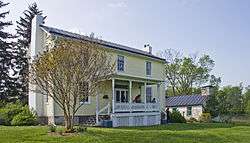
William Grubb Farm |
|
November 21, 1991
(#91001735) |
County Road 340/2, west of its junction with U.S. Route 340
39°14′25″N 77°54′12″W / 39.240278°N 77.903333°W / 39.240278; -77.903333 (William Grubb Farm) |
Charles Town |
|
| 30 |
Halltown Colored Free School |
|
August 25, 2004
(#04000912) |
Halltown Rd., 0.5 mi (0.80 km) northeast of U.S. Route 340
39°18′44″N 77°48′06″W / 39.312222°N 77.801667°W / 39.312222; -77.801667 (Halltown Colored Free School) |
Halltown |
|
| 31 |
Halltown Union Colored Sunday School |
|
January 12, 1984
(#84003591) |
Off U.S. Route 340
39°18′34″N 77°48′11″W / 39.309444°N 77.803056°W / 39.309444; -77.803056 (Halltown Union Colored Sunday School) |
Halltown |
|
| 32 |
Harewood |
|
March 14, 1973
(#73001909) |
West of Charles Town off WV 51
39°18′09″N 77°55′11″W / 39.3025°N 77.919722°W / 39.3025; -77.919722 (Harewood) |
Charles Town |
|
| 33 |
Harpers Ferry Historic District |
|
October 15, 1979
(#79002584) |
Off U.S. Route 340
39°19′35″N 77°44′29″W / 39.326389°N 77.741389°W / 39.326389; -77.741389 (Harpers Ferry Historic District) |
Harpers Ferry |
|
| 34 |
Harpers Ferry National Historical Park |
|
October 15, 1966
(#66000041) |
At confluence of the Shenandoah and Potomac rivers
39°18′59″N 77°43′09″W / 39.316389°N 77.719167°W / 39.316389; -77.719167 (Harpers Ferry National Historical Park) |
Harpers Ferry |
Boundary increase listed May 10, 2016 |
| 35 |
Hazelfield |
|
December 12, 1976
(#76001938) |
Off County Road 48/2
39°22′25″N 77°51′36″W / 39.373611°N 77.86°W / 39.373611; -77.86 (Hazelfield) |
Shenandoah Junction |
|
| 36 |
The Hermitage |
|
December 23, 1993
(#93001444) |
Kabletown Rd. (County Road 25) north of its junction with Mt. Hammond Rd.
39°14′53″N 77°50′30″W / 39.248056°N 77.841667°W / 39.248056; -77.841667 (The Hermitage) |
Charles Town |
|
| 37 |
Hillside |
|
December 12, 1985
(#85003521) |
Old Cave Rd.
39°15′47″N 77°52′05″W / 39.263056°N 77.868056°W / 39.263056; -77.868056 (Hillside) |
Charles Town |
|
| 38 |
Hopewell |
|
March 25, 1994
(#94000214) |
Bloomery Rd. (County Road 27) northeast of Bloomery
39°16′04″N 77°47′36″W / 39.267778°N 77.793333°W / 39.267778; -77.793333 (Hopewell) |
Charles Town |
|
| 39 |
Jacks-Manning Farm |
|
January 12, 1984
(#84003594) |
U.S. Route 340
39°16′08″N 77°51′38″W / 39.268889°N 77.860556°W / 39.268889; -77.860556 (Jacks-Manning Farm) |
Charles Town |
|
| 40 |
Jefferson County Alms House |
|
April 14, 1995
(#95000418) |
West Virginia Secondary Route 15 southeast of Leetown
39°20′07″N 77°54′30″W / 39.335278°N 77.908333°W / 39.335278; -77.908333 (Jefferson County Alms House) |
Leetown |
|
| 41 |
Jefferson County Courthouse |
|
July 10, 1973
(#73001910) |
N. George and E. Washington Sts.
39°17′21″N 77°51′37″W / 39.289167°N 77.860278°W / 39.289167; -77.860278 (Jefferson County Courthouse) |
Charles Town |
|
| 42 |
Lee-Longsworth House |
|
September 23, 1985
(#85002471) |
1141 Washington St.
39°19′32″N 77°44′49″W / 39.325556°N 77.746944°W / 39.325556; -77.746944 (Lee-Longsworth House) |
Harpers Ferry |
|
| 43 |
Captain William Lucas and Robert Lucas House |
|
September 2, 1982
(#82004323) |
Engle Molers Road
39°24′06″N 77°46′27″W / 39.401667°N 77.774167°W / 39.401667; -77.774167 (Captain William Lucas and Robert Lucas House) |
Shepherdstown |
|
| 44 |
James Marshall House |
|
September 27, 1988
(#88001596) |
Shepherd Grade
39°27′15″N 77°49′31″W / 39.454167°N 77.825278°W / 39.454167; -77.825278 (James Marshall House) |
Shepherdstown |
|
| 45 |
Media Farm |
|
November 10, 1994
(#93000616) |
Flowing Springs Rd. (County Road 17), 2 mi (3.2 km) north of Charles Town
39°19′46″N 77°50′32″W / 39.329444°N 77.842222°W / 39.329444; -77.842222 (Media Farm) |
Charles Town |
|
| 46 |
Middleway Historic District |
|
March 13, 1980
(#80004025) |
Leetown Road
39°18′13″N 77°58′58″W / 39.303611°N 77.982778°W / 39.303611; -77.982778 (Middleway Historic District) |
Middleway |
|
| 47 |
Morgan's Grove |
|
March 19, 1999
(#99000286) |
Roughly bounded by West Virginia Routes 230 and 480, and Morgan's Grove Rd.
39°25′04″N 77°48′45″W / 39.417778°N 77.8125°W / 39.417778; -77.8125 (Morgan's Grove) |
Shepherdstown |
|
| 48 |
Morgan-Bedinger-Dandridge House |
|
May 13, 1983
(#83003239) |
Southwest of Shepherdstown on WV 480
39°25′37″N 77°48′43″W / 39.426944°N 77.811944°W / 39.426944; -77.811944 (Morgan-Bedinger-Dandridge House) |
Shepherdstown |
|
| 49 |
New Opera House |
|
November 24, 1978
(#78002798) |
200-204 N. George St.
39°17′23″N 77°51′39″W / 39.289722°N 77.860833°W / 39.289722; -77.860833 (New Opera House) |
Charles Town |
|
| 50 |
Old Charles Town Historic District |
|
November 2, 2000
(#00001308) |
Norfolk & Western railroad line, Charles Town line, Hessey Pl., North St., U.S. Route 340, S. Charles St., Water St., and W. Washington St
39°17′14″N 77°51′43″W / 39.287222°N 77.861944°W / 39.287222; -77.861944 (Old Charles Town Historic District) |
Charles Town |
|
| 51 |
Potomac Mills |
|
February 5, 2014
(#13001166) |
River & Trough Rds.
39°25′42″N 77°46′48″W / 39.428221°N 77.779986°W / 39.428221; -77.779986 (Potomac Mills) |
Shepherdstown |
|
| 52 |
Prato Rio |
|
April 11, 1973
(#73001916) |
WV 480
39°20′49″N 77°56′12″W / 39.346944°N 77.936667°W / 39.346944; -77.936667 (Prato Rio) |
Leetown |
|
| 53 |
Rellim Farm |
|
December 4, 1998
(#98001467) |
Leetown Rd., south of WV 9
39°22′51″N 77°53′15″W / 39.380833°N 77.8875°W / 39.380833; -77.8875 (Rellim Farm) |
Kearneysville |
|
| 54 |
Richwood Hall |
|
June 19, 1973
(#73001911) |
About 4 mi (6.4 km) west of Charles Town off WV 51
39°17′32″N 77°55′51″W / 39.292222°N 77.930833°W / 39.292222; -77.930833 (Richwood Hall) |
Charles Town |
|
| 55 |
Rion Hall |
|
September 20, 1982
(#82004320) |
East of Charles Town off U.S. Route 340
39°18′05″N 77°48′19″W / 39.30147°N 77.80536°W / 39.30147; -77.80536 (Rion Hall) |
Charles Town |
|
| 56 |
Ripon Lodge |
|
August 31, 1998
(#98001074) |
Junction of U.S. Route 340 and Withers-Carve Rd.
39°13′21″N 77°54′30″W / 39.2225°N 77.908333°W / 39.2225; -77.908333 (Ripon Lodge) |
Rippon |
|
| 57 |
Rock Spring |
|
January 17, 2008
(#07001416) |
2000 Ridge Rd.
39°23′02″N 77°50′38″W / 39.383958°N 77.843767°W / 39.383958; -77.843767 (Rock Spring) |
Shepherdstown |
|
| 58 |
Rockland |
|
February 5, 1990
(#89002316) |
WV 480
39°24′30″N 77°51′29″W / 39.408333°N 77.858056°W / 39.408333; -77.858056 (Rockland) |
Shepherdstown |
|
| 59 |
Rose Hill Farm |
|
May 18, 1990
(#90000716) |
Off WV 480 southeast of its junction with Warm Springs Rd.
39°23′48″N 77°51′45″W / 39.396667°N 77.8625°W / 39.396667; -77.8625 (Rose Hill Farm) |
Shepherdstown |
|
| 60 |
Rumsey Hall |
|
March 30, 1973
(#73001919) |
German and Princess Sts.
39°25′57″N 77°48′13″W / 39.4325°N 77.803611°W / 39.4325; -77.803611 (Rumsey Hall) |
Shepherdstown |
|
| 61 |
St. Peter's Roman Catholic Church |
|
March 30, 1973
(#73001915) |
Church St. and Jefferson Rock Trail
39°19′28″N 77°43′53″W / 39.324444°N 77.731389°W / 39.324444; -77.731389 (St. Peter's Roman Catholic Church) |
Harpers Ferry |
|
| 62 |
Shannondale Springs |
|
March 31, 1998
(#98000289) |
Off Mission Rd., south of WV 115
39°13′13″N 77°48′58″W / 39.220278°N 77.816111°W / 39.220278; -77.816111 (Shannondale Springs) |
Shannondale |
|
| 63 |
Shepherd's Mill |
|
May 6, 1971
(#71000882) |
High St.
39°26′00″N 77°48′05″W / 39.433333°N 77.801389°W / 39.433333; -77.801389 (Shepherd's Mill) |
Shepherdstown |
|
| 64 |
Shepherdstown Historic District |
|
August 17, 1973
(#73001920) |
Bounded roughly by Mill, Rocky, Duke, and Washington Sts.
39°25′58″N 77°48′24″W / 39.432778°N 77.806667°W / 39.432778; -77.806667 (Shepherdstown Historic District) |
Shepherdstown |
|
| 65 |
South Charles Town Historic District |
|
September 16, 2009
(#09000733) |
S. George, S. Mildred, S. Samuel, & S. Church Sts.
39°16′41″N 77°51′09″W / 39.278014°N 77.852486°W / 39.278014; -77.852486 (South Charles Town Historic District) |
Charles Town |
|
| 66 |
Strider Farm |
|
February 1, 1988
(#87002524) |
Bakerton Road
39°20′03″N 77°45′55″W / 39.334167°N 77.765278°W / 39.334167; -77.765278 (Strider Farm) |
Harpers Ferry |
|
| 67 |
Sunnyside Farm |
|
March 18, 1999
(#99000285) |
Leetown Rd.
39°19′53″N 77°57′31″W / 39.3314°N 77.958683°W / 39.3314; -77.958683 (Sunnyside Farm) |
Kearneysville |
|
| 68 |
Tackley Farm |
|
November 4, 1994
(#94001286) |
WV 9 2 mi (3.2 km) east of its junction with WV 480
39°21′50″N 77°52′21″W / 39.36395°N 77.87252°W / 39.36395; -77.87252 (Tackley Farm) |
Shenandoah Junction |
|
| 69 |
Traveller's Rest |
|
November 15, 1972
(#72001288) |
3.3 mi (5.3 km) northwest of Leetown on WV 480
39°23′17″N 77°54′04″W / 39.38814°N 77.90120°W / 39.38814; -77.90120 (Traveller's Rest) |
Kearneysville |
|
| 70 |
Van Swearingen-Shepherd House |
|
August 18, 1983
(#83003241) |
North of Shepherdstown
39°26′28″N 77°48′14″W / 39.441111°N 77.803889°W / 39.441111; -77.803889 (Van Swearingen-Shepherd House) |
Shepherdstown |
|
| 71 |
Charles Washington House |
|
July 2, 1973
(#73001912) |
Blakely Pl.
39°16′56″N 77°51′35″W / 39.282222°N 77.859722°W / 39.282222; -77.859722 (Charles Washington House) |
Charles Town |
|
| 72 |
White House Farm |
|
August 29, 1979
(#79002583) |
Summit Point Road
39°15′05″N 77°56′45″W / 39.251389°N 77.945833°W / 39.251389; -77.945833 (White House Farm) |
Summit Point |
|
| 73 |
Wild Goose Farm |
|
April 20, 2018
(#100001902) |
2935 Shepherd Grade Rd.
39°28′26″N 77°48′59″W / 39.4738°N 77.8165°W / 39.4738; -77.8165 (Wild Goose Farm) |
Sheperdstown vicinity |
|
| 74 |
Woodbury |
|
October 9, 1974
(#74002005) |
On County Road 1/4
39°21′28″N 77°54′29″W / 39.357778°N 77.908056°W / 39.357778; -77.908056 (Woodbury) |
Leetown |
|
| 75 |
Woodlawn |
|
March 24, 2000
(#00000254) |
30 Wiltshire Rd.
39°20′21″N 77°53′07″W / 39.339167°N 77.885278°W / 39.339167; -77.885278 (Woodlawn) |
Kearneysville |
|
| 76 |
Robert Worthington House |
|
July 2, 1973
(#73001913) |
2 mi (3.2 km) west of Charles Town off WV 51
39°17′46″N 77°53′23″W / 39.296111°N 77.889722°W / 39.296111; -77.889722 (Robert Worthington House) |
Charles Town |
|
| 77 |
York Hill |
|
July 26, 2006
(#06000654) |
1583 Ridge Rd.
39°22′36″N 77°50′47″W / 39.37667°N 77.84639°W / 39.37667; -77.84639 (York Hill) |
Shenandoah Junction |
|