Marlowe, West Virginia
| Marlowe | |
|---|---|
| Unincorporated community | |
 Marlowe Location within the state of West Virginia  Marlowe Marlowe (the US) | |
| Coordinates: 39°35′18″N 77°51′34″W / 39.58833°N 77.85944°WCoordinates: 39°35′18″N 77°51′34″W / 39.58833°N 77.85944°W | |
| Country | United States |
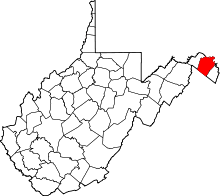
| State | West Virginia |
| County | Berkeley |
| Elevation | 515 ft (157 m) |
| Time zone | UTC-5 (Eastern (EST)) |
| • Summer (DST) | UTC-4 (EDT) |
| GNIS feature ID | 1542770[1] |
Marlowe is an unincorporated community on U.S. Route 11 in Berkeley County, West Virginia, United States.[1]
Sites on the National Register of Historic Places located near Marlowe are: the Charles Downs II House, Harmony Cemetery, Marlowe Consolidated School, and Power Plant and Dam No. 5.[2]
References
- 1 2 "Marlowe". Geographic Names Information System. United States Geological Survey.
- ↑ National Park Service (2009-03-13). "National Register Information System". National Register of Historic Places. National Park Service.
This article is issued from
Wikipedia.
The text is licensed under Creative Commons - Attribution - Sharealike.
Additional terms may apply for the media files.