Cumbum, Andhra Pradesh
| Cumbum | |
|---|---|
| Census Town | |
 Cumbum Lake | |
 Cumbum Location in Andhra Pradesh, India | |
| Coordinates: 15°34′00″N 79°07′00″E / 15.5667°N 79.1167°ECoordinates: 15°34′00″N 79°07′00″E / 15.5667°N 79.1167°E | |
| Country | India |
| State | Andhra Pradesh AP |
| District | Prakasam |
| Mandal | Cumbum |
| Area[1] | |
| • Total | 8.81 km2 (3.40 sq mi) |
| Population (2011)[2] | |
| • Total | 15,169 |
| • Density | 1,700/km2 (4,500/sq mi) |
| Languages | |
| • Official | Telugu |
| Time zone | UTC+5:30 (IST) |
| PIN | 523333 |
| Telephone code | +91–8406 |
| Vehicle registration | AP |
Cumbum is a census town in the Prakasam district of the Indian state of Andhra Pradesh. It is the headquarters of the Cumbum Mandal in the Markapur revenue division.[3] It was a taluk in the Kurnool district before it merged with the other taluks from the Kurnool, Guntur, and Nellore districts to form the Prakasam district. Originally, however, the town was part of Rayalaseema.
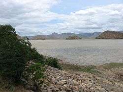
Cumbum Lake
Cumbum Lake, also known as Gundlakamma Lake, was built on the Gundlakamma rivulet upon Nallamalai hills. It is one of the oldest man-made lakes in Asia. The anicut was built by the Vijayanagar Princess Varadharajamma (also known as Ruchidevi), wife of Sri Krishna Devaraya. She was also the daughter of Gajapatis of Orissa. The lake is about 7 km long and about 3.5 km wide. According to the Imperial Gazette of India, at the turn of the 20th century, the dam was 57 feet (17 m) tall, and the drainage area was 430 square miles (1,100 km2). The directly irrigated land was about 10,300 acres (42 km2) in all. It is the second largest irrigation tank in Asia.[4] Cumbum Lake is accessible both by the Guntur-Nandyal railway line and from Ongole by road.
History
There are inscriptions at Cumbum and Bestawaripeta, one from 1706, and another from 1729. The first refers to the death of the sheriff Khaja Muhammad, who was the Qiladar of Cumbum fort during the reign of Aurangazeb. The second refers to Muhammad Sahib, son of Muhammad Khayum of Tab and governor of Cumbum during the reign of Muhammad Shah. It also states that Muhammad Sahib had a mosque constructed at Cumbum during his governorship. These inscriptions prove that this district, like other districts in the Qutub Shahi Kingdom, was once under the Mughal rule. It was formed as part of the Golkonda province, one of the six provinces into which the Deccan Suba was sub-divided int.[5]
During the British Raj period, Cumbum tehsil was a municipality of Kurnool district; as such, it had a regimental garrison and a collectorate.[6]
Geography
Cumbum is located at 15°34′01″N 79°07′00″E / 15.5669°N 79.1167°E.[7]. It has an average elevation of 184 metres (606 ft).
.
Transport
Cumbum railway station provides rail connectivity and is a D-category railway station in the Guntur railway division of the South Central Railway zone.[8] State highways, roads, and the Vijayawada–Guntakal railway line pass through the town.
Politics
The town was an assembly constituency in Andhra Pradesh until 2009.[9] Muthamulu Ashok Reddy won the 2014 assembly elections when the Cumbum constituency was reorganized and merged with the Giddalur constituency.
Education
The primary and secondary school education is provided by the government's School Education Department.[10][11] The languages of instruction followed by different schools are English and Telugu.
References
- ↑ "District Census Handbook - Prakasam" (PDF). Census of India. p. 16,17,48. Retrieved 18 January 2015.
- ↑ "Census 2011". The Registrar General & Census Commissioner, India. Retrieved 26 July 2014.
- ↑ "Prakasam District Mandals" (PDF). Census of India. pp. 135, 174. Retrieved 19 June 2015.
- ↑ "Cumbum tank a big draw in Prakasam". The Hindu. Retrieved 2017-04-10.
- ↑ "District Census Handbook - Prakasam" (PDF). Census of India. p. 14. Retrieved 18 January 2015.
- ↑ "Full text of "The Imperial Gazetteer Of India Provincial Series Madras Vol.-i"". archive.org. Retrieved 2017-04-10.
- ↑ "Maps, Weather, and Airports for Cumbum, India". fallingrain.com.
- ↑ "Evolution of Guntur Division" (PDF). South Central Railway. p. 11. Retrieved 3 May 2016.
- ↑ APAssembly results 1978–2004 Archived 2007-09-30 at the Wayback Machine.. Election Commission of India.
- ↑ "School Education Department" (PDF). School Education Department, Government of Andhra Pradesh. Archived from the original (PDF) on 27 December 2015. Retrieved 7 November 2016.
- ↑ "The Department of School Education - Official AP State Government Portal | AP State Portal". www.ap.gov.in. Archived from the original on 7 November 2016. Retrieved 7 November 2016.