Culross, Manitoba
| Culross | |
|---|---|
 Culross Location of Culross in Manitoba | |
| Coordinates: 49°42′51″N 97°54′40″W / 49.71417°N 97.91111°WCoordinates: 49°42′51″N 97°54′40″W / 49.71417°N 97.91111°W | |
| Country |
|
| Province |
|
| Region | Pembina Valley |
| Census Division | No. 9 |
| Government | |
| • Governing Body | Rural Municipality of Grey Council |
| • MP | Candice Bergen |
| • MLA | Blaine Pedersen |
| Time zone | UTC−6 (CST) |
| • Summer (DST) | UTC−5 (CDT) |
| Area code(s) | 204 |
| NTS Map | 062H12 |
| GNBC Code | GAFYV |
Culross is an unincorporated community in south central Manitoba, Canada. It is located approximately 58 kilometers (36 miles) west of Winnipeg[1] on Manitoba Highway 2 in the Rural Municipality of Grey.
References
- ↑ "Geographical Names of Canada - Querying Distances". nrcan.gc.ca. 2011-10-24. Archived from the original on 2014-04-16. Retrieved 2012-10-09.
- ↑ Geographic Board of Canada (1933). Place-names of Manitoba. Ottawa: J. O. Patenaude, acting King's printer. p. 26. Retrieved 11 October 2017.
| Cities | 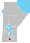 | ||
|---|---|---|---|
| Villages |
| ||
| Rural municipalities | |||
| First Nations | |||
| Indian reserves | |||
| Unincorporated communities | |||
This article is issued from
Wikipedia.
The text is licensed under Creative Commons - Attribution - Sharealike.
Additional terms may apply for the media files.